Related Research Articles

Lake of the Woods County is a county in the northwestern part of the U.S. state of Minnesota. As of the 2020 United States Census, the population was 3,763, making it the second-least populous county in Minnesota. Its county seat is Baudette.

Ault Township is a township in Saint Louis County, Minnesota, United States. The population was 109 at the 2010 census.
Fairbanks Township is a township in Saint Louis County, Minnesota, United States. The population was 63 at the 2010 census.
Upper Red Lake is an unorganized territory in Beltrami County, Minnesota, U.S. It is a part of the Red Lake Indian Reservation. The population was 25 at the 2000 census.
Angleworm Lake is an unorganized territory in Saint Louis County, Minnesota, United States. As of the 2000 census, the unorganized territory had a total population of 0.
Crab Lake is an unorganized territory in Saint Louis County, Minnesota, United States, located north of Eagles Nest Township, and west of Morse Township. The population was 11 at the 2000 census.
Gheen is an unorganized territory in Saint Louis County, Minnesota, United States. The population was 25 at the 2000 census.
Hay Lake is an unorganized territory in Saint Louis County, Minnesota, United States. The population was 98 at the 2000 census.
Heikkala Lake is an unorganized territory in Saint Louis County, Minnesota, United States. The population was 322 at the 2000 census.
Jeanette Lake is an unorganized territory in Saint Louis County, Minnesota, United States. The population was 249 at the 2000 census.
Kabetogama Township is a township in Saint Louis County, Minnesota, United States. The population was 135 at the 2010 census. A portion of the township is located within the Kabetogama State Forest.
Mud Hen Lake is an unorganized territory in Saint Louis County, Minnesota, United States. The population was 320 at the 2000 census.
Northwest St. Louis is an unorganized territory in Saint Louis County, Minnesota, United States. The population was 306 at the 2000 census.
Pfeiffer Lake is an unorganized territory in Saint Louis County, Minnesota, United States. The 2000 census population was three.
Potshot Lake is an unorganized territory in Saint Louis County, Minnesota, United States, located near Floodwood. The population was 73 at the 2000 census.
Tikander Lake is an unorganized territory in Saint Louis County, Minnesota, United States. The population was 783 at the 2000 census.
Whiteface Reservoir is an unorganized territory in Saint Louis County, Minnesota, United States. The population was 292 at the 2000 census.
Nett Lake is an unorganized territory in Saint Louis County, Minnesota, United States. The population was 272 at the 2000 census.
Bois Forte Indian Reservation is an Indian reservation formed for the Bois Forte Band of Chippewa.
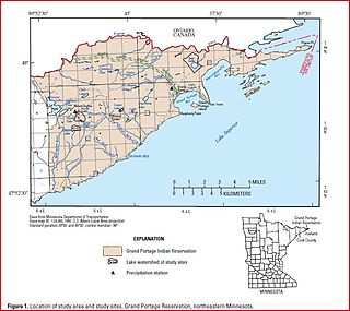
The Grand Portage Indian Reservation is located in Cook County near the tip of Minnesota's Arrowhead Region in the extreme northeast part of the state. The community was considered part of the Lake Superior Band of Chippewa, but is not a party to the treaties that group signed. The reservation was established as part of an 1854 treaty, and the land area is 74.396 sq mi (192.686 km²).
References
- ↑ Minnesota 2000: Census of Population and Housing, p. 30 (U.S. Dept. of Commerce, 2000).
- ↑ Chippewa and Superior National Forests (N.F.), Forest Plan Revision: Environmental Impact Statement, p. 65 (U.S. Dept. of Agriculture, 2003).
- 1 2 3 "Picket Lake". USDA Forest Service, Superior National Forest. Retrieved 2013-09-29.
