Geomorphology is the scientific study of the origin and evolution of topographic and bathymetric features generated by physical, chemical or biological processes operating at or near Earth's surface. Geomorphologists seek to understand why landscapes look the way they do, to understand landform and terrain history and dynamics and to predict changes through a combination of field observations, physical experiments and numerical modeling. Geomorphologists work within disciplines such as physical geography, geology, geodesy, engineering geology, archaeology, climatology, and geotechnical engineering. This broad base of interests contributes to many research styles and interests within the field.

In geomorphology and geology, a peneplain is a low-relief plain formed by protracted erosion. This is the definition in the broadest of terms, albeit with frequency the usage of peneplain is meant to imply the representation of a near-final stage of fluvial erosion during times of extended tectonic stability. Peneplains are sometimes associated with the cycle of erosion theory of William Morris Davis, but Davis and other workers have also used the term in a purely descriptive manner without any theory or particular genesis attached.

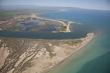
Bohuslän (Swedish pronunciation:[ˈbûːhʉːsˌlɛːn] is a Swedish province in Götaland, on the northernmost part of the country's west coast. It is bordered by Dalsland to the northeast, Västergötland to the southeast, the Skagerrak arm of the North Sea to the west, and the county of Østfold, in Norway, to the north. In English it literally means Bohus County, although it shared counties with the city of Gothenburg prior to the 1998 county merger and thus was not an administrative unit in its own right.

The Baltic Shield is a segment of the Earth's crust belonging to the East European Craton, representing a large part of Fennoscandia, northwestern Russia and the northern Baltic Sea. It is composed mostly of Archean and Proterozoic gneisses and greenstone which have undergone numerous deformations through tectonic activity. It contains the oldest rocks of the European continent with a thickness of 250–300 km.

A shield is a large area of exposed Precambrian crystalline igneous and high-grade metamorphic rocks that form tectonically stable areas. These rocks are older than 570 million years and sometimes date back to around 2 to 3.5 billion years. They have been little affected by tectonic events following the end of the Precambrian, and are relatively flat regions where mountain building, faulting, and other tectonic processes are minor, compared with the activity at their margins and between tectonic plates. Shields occur on all continents.

Mountain formation refers to the geological processes that underlie the formation of mountains. These processes are associated with large-scale movements of the Earth's crust. Folding, faulting, volcanic activity, igneous intrusion and metamorphism can all be parts of the orogenic process of mountain building. The formation of mountains is not necessarily related to the geological structures found on it.
The geographic cycle, or cycle of erosion, is an idealized model that explains the development of relief in landscapes. The model starts with the erosion that follows uplift of land above a base level and ends, if conditions allow, in the formation of a peneplain. Landscapes that show evidence of more than one cycle of erosion are termed "polycyclical". The cycle of erosion and some of its associated concepts have, despite their popularity, been a subject of much criticism.
In geology, epeirogenic movement is upheavals or depressions of land exhibiting long wavelengths and little folding apart from broad undulations. The broad central parts of continents are called cratons, and are subject to epeirogeny. The movement may be one of subsidence toward, or of uplift from, the center of Earth. The movement is caused by a set of forces acting along an Earth radius, such as those contributing to isostasy and faulting in the lithosphere.

Sheet erosion or sheet wash is the even erosion of substrate along a wide area. It occurs in a wide range of settings such as coastal plains, hill slopes, floodplains, beaches, savanna plains and semi-arid plains. Water moving fairly uniformly with a similar thickness over a surface is called sheet flow, and is the cause of sheet erosion. Sheet erosion implies that any flow of water that causes the erosion is not canalized. If a hillslope surface contains many irregularities, sheet erosion may give way to erosion along small channels called rills, which can then converge forming gullies. However, sheet erosion may occur despite some limited unevenness in the sheet flow arising from clods of earth, rock fragments, or vegetation.
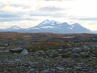
The Scandinavian Mountains or the Scandes is a mountain range that runs through the Scandinavian Peninsula. The western sides of the mountains drop precipitously into the North Sea and Norwegian Sea, forming the fjords of Norway, whereas to the northeast they gradually curve towards Finland. To the north they form the border between Norway and Sweden, reaching 2,000 metres (6,600 ft) high at the Arctic Circle. The mountain range just touches northwesternmost Finland but are scarcely more than hills at their northernmost extension at the North Cape.

The geology of South Africa is highly varied including cratons, greenstone belts, large impact craters as well as orogenic belts. The geology of the country is the base for a large mining sector that extracts gold, diamonds, iron and coal from world-class deposits. The geomorphology of South Africa consists of a high plateau rimmed to west, south and southeast by the Great Escarpment, and the rugged mountains of the Cape Fold Belt. Beyond this there is strip of narrow coastal plain.
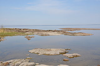
The sub-Cambrian peneplain is an ancient, extremely flat, erosion surface (peneplain) that has been exhumed and exposed by erosion from under Cambrian strata over large swathes of Fennoscandia. Eastward, where this peneplain dips below Cambrian and other Lower Paleozoic cover rocks. The exposed parts of this peneplain are extraordinarily flat with relief of less than 20 m. The overlying cover rocks demonstrate that the peneplain was flooded by shallow seas during the Early Paleozoic. Being the oldest identifiable peneplain in its area the Sub-Cambrian peneplain qualifies as a primary peneplain.

The South Swedish highlands or South Swedish Uplands are a hilly area covering large parts of Götaland in southern Sweden. Except for a lack of deep valleys, the landscape is similar to the Norrland terrain found further north in Sweden. The central-eastern parts of the highlands contain about thirty narrow canyons locally known as skurus.

The South Småland peneplain is a large flattish erosion surface, a peneplain, formed during the Tertiary, covering large swathes of southern Småland and nearby areas in Southern Sweden. To the east the South Småland peneplain bounds with the Sub-Cambrian peneplain uphill across an escarpment. While is almost as flat as the Sub-Cambrian peneplain the South Småland peneplain differs in that it contains far more residual hills and that it has never been covered by sedimentary rocks. To the south and west the peneplain transitions into Mesozoic-aged hilly surfaces.

The paleic surface or palaeic surface is an erosion surface of gentle slopes that exist in South Norway. Parts of it are a continuation of the Sub-Cambrian peneplain and Muddus Plains found further east or equivalent to the strandflat coastal plains of Norway. Hardangervidda, a particularly flat and elevated part of the Paleic surface formed in the Miocene at sea level.
Hügelland is a type of landscape consisting of low rolling hills whose topography or surface structure lies between that of a lowland region and that of a more rugged hill range or low mountain range. The term is German and has no exact equivalent in English, but is often translated as "hill country", "hilly terrain", "upland(s)" or "gently undulating" or "rolling country", or "rolling countryside". It is derived from Hügel, a low hill or hillock and appears frequently as a proper name for this type of terrain.
In geology and geomorphology a paleosurface is a surface made by erosion of considerable antiquity. Paleosurfaces might be flat or uneven in some cases having considerable relief. Flat and large paleosurfaces —that is planation surfaces— have higher potential to be preserved than small and irregular surfaces and are thus the most studied kind of paleosurfaces. Irregular paleosurfaces, albeit usually smaller than flat ones, occur across the globe, one example being the Sudetes etchsurfaces. In the case of peneplains it is argued that they become paleosurfaces once they are detached from the base level they grade to.
The glacial buzzsaw is a hypothesis claiming erosion by warm-based glaciers is key to limit the height of mountains above certain threshold altitude. To this the hypothesis adds that great mountain massifs are leveled towards the equilibrium line altitude (ELA), which would act as a “climatic base level”. Starting from the hypothesis it has been predicted that local climate restricts the maximum height that mountain massifs can attain by effect of uplifting tectonic forces. It follows that as local climate is cooler at higher latitudes the highest mountains are lower there compared to the tropics where glaciation is and has been more limited. The mechanism behind the glacial buzzsaw effect would be the erosion of small glaciers that are mostly unable to erode much below the equilibrium line altitude since they do not reach these altitudes because of increased ablation. Instead, large valley glaciers may easily surpass the equilibrium line altitude and do therefore not contribute to a glacial buzzsaw effect. This is said to be the case of the Patagonian ice fields where lack of buzzsaw effect results in rapid tectonic uplift rates.

The Sub-Mesozoic hilly peneplains or Sub-Mesozoic hilly relief is a landscape in Scandinavia made up of undulating hills and joint valleys and occasional kaolinized bedrock in valley bottoms. The landscape formed in the Mesozoic Era and was eventually drowned by the sea during the Campanian transgression and covered by a thick cover of Cretaceous sedimentary rocks. Later erosion of the cover rocks partly re-exposed this landscape. During the Quaternary epoch the re-exposed Mesozoic hilly relief escaped major glacier erosion being only surficially scoured in parts.
A piedmonttreppen or piedmont benchland is a conceived landform consisting in a succession of benches at different heights and that forms in sequence during the uplift of a geological dome. The concept was first proposed in a posthumous publication by Walther Penck in 1924.