
The Hill of Tara is a hill and ancient ceremonial and burial site near Skryne in County Meath, Ireland. Tradition identifies the hill as the inauguration place and seat of the High Kings of Ireland; it also appears in Irish mythology. Tara consists of numerous monuments and earthworks—dating from the Neolithic to the Iron Age—including a passage tomb, burial mounds, round enclosures, a standing stone, and a ceremonial avenue. There is also a church and graveyard on the hill. Tara forms part of a larger ancient landscape and Tara itself is a protected national monument under the care of the Office of Public Works, an agency of the Irish Government.

A tumulus is a mound of earth and stones raised over a grave or graves. Tumuli are also known as barrows, burial mounds or kurgans, and may be found throughout much of the world. A cairn, which is a mound of stones built for various purposes, may also originally have been a tumulus.

Arbor Low is a well-preserved Neolithic henge in the Derbyshire Peak District, England. It lies on a Carboniferous Limestone plateau known as the White Peak area. The monument consists of a stone circle surrounded by earthworks and a ditch.

The Stanton Drew stone circles are just outside the village of Stanton Drew in the English county of Somerset. The largest stone circle is the Great Circle, 113 metres (371 ft) in diameter and the second largest stone circle in Britain ; it is considered to be one of the largest Neolithic monuments to have been built. The date of construction is not known, but is thought to be between 3000 and 2000 BCE, which places it in the Late Neolithic to Early Bronze Age. It was made a scheduled monument in 1982.

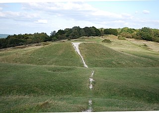
Small Down Knoll, or Small Down Camp, is a Bronze Age hill fort near Evercreech in Somerset, England. The hill is on the southern edge of the Mendip Hills, and rises to 222 m (728 ft).

Dunkery Beacon at the summit of Dunkery Hill is the highest point on Exmoor and in Somerset, England. It is also the highest point in southern England outside of Dartmoor.
Williton is a large village and civil parish in Somerset, England, at the junction of the A39, A358 and B3191 roads, on the coast 2 miles (3.2 km) south of Watchet between Minehead, Bridgwater and Taunton in the now-defunct Somerset West and Taunton district.

The Stoney Littleton Long Barrow is a Neolithic chambered tomb with multiple burial chambers, located near the village of Wellow in the English county of Somerset. It is an example of the Cotswold-Severn Group and was scheduled as an ancient monument in 1882. It was one of the initial monuments included when the Ancient Monuments Protection Act 1882 became law.

The Bull Ring is a Class II henge that was built in the late Neolithic period near Dove Holes in Derbyshire, England.

Priddy Circles are a linear arrangement of four circular earthwork enclosures near the village of Priddy on the Mendip Hills in Somerset, England. The circles have been listed as Scheduled Ancient Monuments, and described as 'probable Neolithic ritual or ceremonial monuments similar to a henge'.

In archaeology, earthworks are artificial changes in land level, typically made from piles of artificially placed or sculpted rocks and soil. Earthworks can themselves be archaeological features, or they can show features beneath the surface.
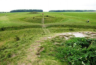
The Cursus Barrows is the name given to a Neolithic and Bronze Age round barrow cemetery lying mostly south of the western end of the Stonehenge Cursus, in Wiltshire, England. The cemetery contains around 18 barrows scattered along an east-to-west ridge, although some of the mounds are no longer visible. The Cursus Barrows can be seen just north of the route between the Stonehenge Visitor Centre and Stonehenge.
Drove Cottage Henge is a scheduled monument in the Priddy parish of Somerset, England. It is located 370 metres (1,210 ft) north of Drove Cottage. The site is a ceremonial Neolithic location. Since this henge is one of only around 80 henges throughout England, it is considered to be nationally important.

Adam's Grave was a Neolithic long barrow near Alton Barnes in Wiltshire, southwest England. Its remains have been scheduled as an ancient monument.
The Devil's Humps are four Bronze Age barrows situated on Bow Hill on the South Downs near Stoughton, West Sussex. They are situated on a downland ridgeway crossed by an ancient trackway, above Kingley Vale. The Devil's Humps are counted among the most impressive round barrows surviving on the South Downs. The Devil's Humps are within the Kingley Vale National Nature Reserve. The two bell barrows together with two pond barrows and a cross dyke are listed as Scheduled Ancient Monument 1008371, while the two bowl barrows are listed as Scheduled Ancient Monument 1008372.
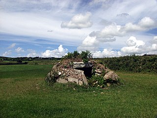
Brane Barrow, or Chapel Euny Barrow, is a Neolithic entrance grave located near the hamlet of Brane, Cornwall, England, UK. It is considered to be one of the smallest and best preserved burial monuments in Britain.

Knowlton Circles are a complex of henges and earthworks in Knowlton, Dorset, England. The henge enclosing Knowlton Church is the best known and best preserved, but there are at least two other henges in the vicinity as well as numerous round barrows.

Priddy Nine Barrows Cemetery and Ashen Hill Barrow Cemetery are a collection of round barrows, dating from the Bronze Age, near Priddy in the English county of Somerset. They are designated as ancient monuments.

Wor Barrow is a Neolithic long barrow on Cranborne Chase, about 1 mile (1.6 km) east of Sixpenny Handley in Dorset, England. It is a scheduled monument.

The Thickthorn Down Long Barrows are two Neolithic long barrows, near the village of Gussage St Michael in Dorset, England. They are near the south-western end of the Dorset Cursus, a Neolithic feature. The long barrows are a scheduled monument.
