Bay Harbor Islands, Florida

Last updated

Bay Harbor Islands, Florida
Town of Bay Harbor Islands
Miami-Dade County Florida Incorporated and Unincorporated areas Bay Harbor Islands Highlighted 1203975.svg
Location in Miami-Dade County, Florida
Bay Harbor Islands.png
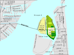
U.S. Census Bureau map showing the Town's boundaries
Coordinates: 25°53′15″N80°8′9″W / 25.88750°N 80.13583°W / 25.88750; -80.13583
Country Flag of the United States.svg  United States of America
State Flag of Florida.svg  Florida
County Flag of Miami-Dade County, Florida.png Miami-Dade
Incorporated April 28, 1947
Government
  Type Council-Manager
   Mayor Joshua D. Fuller
   Vice Mayor Isaac Salver
   Council Members Stephanie Bruder,
Molly Diallo,
Teri D'Amico,
Eric Rappaport, and
Robert H. Yaffe
   Town Manager Maria Lasday
   Town Clerk Yvonne P. Hamilton
Area
[1]
  Total0.42 sq mi (1.09 km2)
  Land0.40 sq mi (1.03 km2)
  Water0.03 sq mi (0.06 km2)
Elevation
7 ft (2 m)
Population
 (2020) [2]
  Total5,922
  Density14,954.55/sq mi (5,768.58/km2)
Time zone UTC-5 (Eastern (EST))
  Summer (DST) UTC-4 (EDT)
ZIP code
33154
Area code(s) 305, 786, 645
FIPS code 12-03975 [3]
GNIS feature ID0278201 [4]
Website www.bayharborislands-fl.gov

Bay Harbor Islands is a town in Miami-Dade County, Florida, United States. The city is part of the Miami metropolitan area of South Florida. It is separated from the mainland by Biscayne Bay. The population was 5,922 at the 2020 US census. [2]

Contents

History

Bay Harbor Islands was founded by Shepard Broad on April 28, 1947.

Geography

Bay Harbor Islands is located at 25°53′15″N80°8′9″W / 25.88750°N 80.13583°W / 25.88750; -80.13583 (25.887522, –80.135739). [5] It sits near the north end of Biscayne Bay and consists of two islands, originally known as Broadview and Bay Harbor, now referred to as, respectively, the West and East Islands. The West Island features single family homes, while the East Island contains the business district, the Ruth K. Broad Bay Harbor K–8 Center, and multi-family housing. To the west, across Biscayne Bay, is the city of North Miami, connected via the Shepard Broad Causeway. To the east, across Indian Creek, lie the village of Bal Harbour and the town of Surfside. To the south across Indian Creek Lake, with no direct road access from Bay Harbor Islands, lies the village of Indian Creek.

Bay Harbor Islands is approximately 15 miles (24 km) (30 minutes driving distance) northeast of Miami International Airport, and 14 miles (23 km) (35 minutes) north of PortMiami.

According to the United States Census Bureau, the town has a total area of 0.4 square miles (1.0 km2), including 0.03 square miles (0.08 km2) (5.94%) of water. [1]

Surrounding areas

East Island architecture

At one time, Bay Harbor Islands East Island featured one of the largest concentrated collections of mid-century Miami Modern architecture. Now, one will find many of these buildings intermixed with contemporary residences and boutique waterfront condominiums.

Demographics

Historical population
CensusPop.Note
1950 296
1960 3,249997.6%
1970 4,61942.2%
1980 4,8695.4%
1990 4,703−3.4%
2000 5,1469.4%
2010 5,6289.4%
2020 5,9225.2%
U.S. Decennial Census [6]

2020 census

Bay Harbor Islands racial composition
(Hispanics excluded from racial categories)
(NH = Non-Hispanic) [7]
RaceNumberPercentage
White (NH)2,74846.40%
Black or African American (NH)1111.87%
Native American or Alaska Native (NH)00.00%
Asian (NH)671.13%
Pacific Islander or Native Hawaiian (NH)00.00%
Some other race (NH)530.89%
Two or more races/Multiracial (NH)2063.48%
Hispanic or Latino 2,73746.22%
Total5,922

As of the 2020 United States census, there were 5,922 people, 2,139 households, and 1,555 families residing in the town. [8]

2010 census

Bay Harbor Islands Demographics
2010 Census Bay Harbor IslandsMiami-Dade CountyFlorida
Total population5,6282,496,43518,801,310
Population, percent change, 2000 to 2010+9.4%+10.8%+17.6%
Population density14,221.7/sq mi1,315.5/sq mi350.6/sq mi
White or Caucasian (including White Hispanic)91.5%73.8%75.0%
(Non-Hispanic White or Caucasian)49.1%15.4%57.9%
Black or African-American 2.5%18.9%16.0%
Hispanic or Latino (of any race) 46.3%65.0%22.5%
Asian 1.2%1.5%2.4%
Native American or Native Alaskan 0.2%0.2%0.4%
Pacific Islander or Native Hawaiian 0.0%0.0%0.1%
Two or more races (Multiracial) 2.3%2.4%2.5%
Some Other Race 2.3%3.2%3.6%

As of the 2010 United States census, there were 5,628 people, 2,494 households, and 1,418 families residing in the town. [9]

2000 census

In 2000, 20.3% had children under the age of 18 living with them, 35.6% were married couples living together, 10.7% had a female householder with no husband present, and 50.4% were non-families. 43.1% of all households were made up of individuals, and 18.6% had someone living alone who was 65 years of age or older. The average household size was 1.97 and the average family size was 2.71.

In 2000, the town's population was spread out, with 18.0% under the age of 18, 5.0% from 18 to 24, 32.1% from 25 to 44, 21.7% from 45 to 64, and 23.3% who were 65 years of age or older. The median age was 42 years. For every 100 females, there were 80.1 males. For every 100 females age 18 and over, there were 75.3 males.

In 2000, the median income for a household in the Town was $38,514, and the median income for a family was $43,939. Males had a median income of $38,750 versus $31,044 for females. The per capita income for the Town was $29,261. About 8.0% of families and 13.1% of the population were below the poverty line, including 20.7% of those under age 18 and 6.8% of those age 65 or over.

As of 2000, speakers of English as a first language constituted 52.05% of the population, while Spanish accounted for 43.90%, Portuguese 1.65%, Hebrew 1.30%, and French 1.10%. [10]

Education

Ruth K. Broad Bay Harbor K–8 Center in Bay Harbor Islands serves as the local elementary and K–8 school. Residents who want to have a conventional middle school may instead choose the zoned middle school, [11] Miami Beach Nautilus Middle School. [12] Miami Beach Senior High School is the senior high school serving this area. [13]

Notable people

In the TV series Dexter the title character Dexter Morgan's apartment is in Miami, but a real condo in Bay Harbor Islands was used for the exterior shooting location. In the second season of Dexter, the discovery of Dexter's victims' remains inspires the press to dub the serial killer the "Bay Harbor Butcher". [20]

Parts of the video for the song "La Tortura" by Colombian recording artist, Shakira, featuring Spanish recording artist Alejandro Sanz, was recorded at the historic Coral Sea Towers building in Bay Harbor Islands.

Related Research Articles

<span class="mw-page-title-main">Aventura, Florida</span> City in Florida

Aventura is a planned suburban city in northeastern Miami-Dade County, Florida, United States, 15 miles (24 km) north of Miami and part of the Miami metropolitan area of South Florida. The city is especially known for Aventura Mall, the third largest mall in the United States by total square feet of retail space and the largest mall in Florida.

<span class="mw-page-title-main">Bal Harbour, Florida</span> Village in Florida

Bal Harbour is a village in Miami-Dade County, Florida. The village is part of the Miami metropolitan area of South Florida. The population was 3,093 at the 2020 US Census.

<span class="mw-page-title-main">Biscayne Park, Florida</span> Village in Florida

Biscayne Park is a village in Miami-Dade County, Florida, United States. It's also part of the Miami metropolitan area of South Florida. As of the 2020 census, the population was at 3,117 residents.

<span class="mw-page-title-main">Cutler Bay, Florida</span> Town in the state of Florida, United States

Cutler Bay is an incorporated town in Miami-Dade County, Florida, United States, established in 2005. With a population of 45,425 as of the 2020 US census, it is part of the Miami metropolitan area of South Florida. Cutler Bay is the 9th most populous of the 34 municipalities that make up Miami's urban core, and the 33rd most populous of the 163 municipalities.

<span class="mw-page-title-main">Fisher Island, Florida</span> Census-designated place in Florida

Fisher Island is a census-designated place in Miami-Dade County, Florida, United States, located on a barrier island of the same name. Since 2015, Fisher Island has the highest per capita income of any place in the United States. It is located in the Miami metropolitan area of South Florida. As of the 2020 census, the population was 561.

<span class="mw-page-title-main">Florida City, Florida</span> City in Florida

Florida City is a city in Miami-Dade County, Florida, United States. It is the southernmost municipality in the South Florida metropolitan area. Florida City is primarily a Miami suburb and a major agricultural area. As of the 2020 census, it had a population of 13,085, up from 11,245 in 2010.

<span class="mw-page-title-main">Golden Beach, Florida</span> Town in Florida

Golden Beach is a town in Miami-Dade County, Florida, United States, between the Intracoastal Waterway and Atlantic Ocean. The town is part of the Miami metropolitan area of South Florida. As of the 2020 US census, the town had a population of 961.

<span class="mw-page-title-main">Homestead, Florida</span> City in Florida

Homestead is a city within Miami-Dade County in the U.S. state of Florida, between Biscayne National Park to the east and Everglades National Park to the west. Homestead is primarily a Miami suburb and a major agricultural area. It is a principal city of the Miami metropolitan area of South Florida, which was home to an estimated 6,012,331 people at the 2015 census. It is located approximately 26 miles (42 km) southwest of Miami, and 25 miles (40 km) northwest of Key Largo. The population was 80,737 as of the 2020 census.

<span class="mw-page-title-main">Indian Creek, Florida</span> Village in Florida

Indian Creek is a village, Gated community, and man-made barrier island in Miami-Dade County, Florida, United States. It has 41 residential home sites and the Indian Creek Country Club. The village is part of the Miami metropolitan area of South Florida. The concentration of highly affluent people on the island has earned it the nickname Billionaire Bunker. The population was 84 at the 2020 census. In 2017 the island was said to be home to 41 waterfront residential home sites and 29 estate homes. All the waterfront homes surround the Indian Creek country club and golf course, which takes up most of the land on the island. Residents of the island are said to have access to the country club which is said to very exclusive, though not all of them are members of the country club. The village has its own government and law enforcement.

<span class="mw-page-title-main">Islandia, Florida</span> Unincorporated community in Florida, United States

Islandia is an unincorporated community and former city in Miami-Dade County, Florida, United States. It is located in the upper Florida Keys on the islands of Elliott Key and other nearby keys, such as Totten Key. It was the only municipality in the Florida Keys not located in neighboring Monroe County. The population was 18 at the 2010 Census. Most residents of the city were National Park Service employees.

<span class="mw-page-title-main">Key Biscayne, Florida</span> Village in Miami-Dade County, Florida

Key Biscayne is an island village in Miami-Dade County, Florida, United States. The village is part of the Miami metropolitan area of South Florida. The population was 14,809 at the 2020 census, up from 12,344 in 2010.

<span class="mw-page-title-main">North Bay Village, Florida</span> City in Florida

North Bay Village is a city located in Miami-Dade County, Florida. The city is part of the Miami metropolitan area of South Florida. As of the 2020 census, the city had a total population of 8,159.

<span class="mw-page-title-main">North Miami, Florida</span> City in Florida

North Miami is a suburban city located in northeast Miami-Dade County, Florida, United States, about 10 miles (16 km) north of Miami. The city lies on Biscayne Bay and hosts the Biscayne Bay Campus of Florida International University.. Originally the "Town of Arch Creek", the area was incorporated as the "Town of Miami Shores", which was renamed the "Town of North Miami" in 1931. It was reincorporated as a city in 1953. The city is part of the Miami metropolitan area of South Florida.

<span class="mw-page-title-main">North Miami Beach, Florida</span> City in Florida

North Miami Beach is a city in Miami-Dade County, Florida, United States. The City of North Miami Beach is part of the Miami metropolitan area of South Florida. Originally named "Fulford-by-the-Sea" in 1926, after Captain William H. Fulford of the U.S. Coast Guard, the city was renamed "North Miami Beach" in 1931. The population was 43,676 at the 2020 US census.

<span class="mw-page-title-main">Sunny Isles Beach, Florida</span> City in Florida

Sunny Isles Beach is a city located on a barrier island in northeast Miami-Dade County, Florida, United States. The city is part of the Miami metropolitan area of South Florida, and is bounded by the Atlantic Ocean on the east and the Intracoastal Waterway on the west. As of the 2020 census, it had a population of 22,342.

<span class="mw-page-title-main">Surfside, Florida</span> Town in the state of Florida, United States

Surfside is a town in Miami-Dade County, Florida, United States. Surfside is a primarily residential beachside community, with several multistory condominium buildings adjacent to Surfside Beach on the Atlantic Ocean. The town is bordered on the south by the North Beach neighborhood of Miami Beach, on the north by Bal Harbour, on the west by Biscayne Bay, and on the east by the Atlantic Ocean. It also serves as part of the Miami metropolitan area of South Florida. The population was 5,689 as of the 2020 census.

<span class="mw-page-title-main">Sweetwater, Miami-Dade County, Florida</span> City in Florida

Sweetwater is a city in Miami-Dade County, Florida, United States. The city is part of the Miami metropolitan area of South Florida. As of the 2020 census, the population was 19,363, up from 13,499 in 2010.

<span class="mw-page-title-main">Miami metropolitan area</span> Metropolis in the U.S. state of Florida

The Miami metropolitan area, also known as South Florida, SoFlo, SoFla, the Gold Coast, the Tri-County Area, or Greater Miami, and officially the Miami–Fort Lauderdale–West Palm Beach Metropolitan Statistical Area, is a coastal metropolitan area in southeastern Florida. It is the ninth-largest metropolitan statistical area (MSA) in the United States, the fifth-largest metropolitan area in the Southern United States, and the largest metropolitan area in Florida. With a population of 6.18 million, its population exceeds 31 of the nation's 50 states as of 2023. It comprises the three most populated counties in the state, Miami-Dade County, Broward County, and Palm Beach County, which rank as the first, second, and third-most populous counties in the state, respectively. Miami-Dade County, with 2,701,767 people in 2020, is the seventh-most populous county in the United States.

<span class="mw-page-title-main">Florida State Road 922</span> Highway in Florida, US

State Road 922 is a 5.548 miles (8.929 km) east–west road built in 1951, passing through the cities of North Miami, Bay Harbor Islands, and Bal Harbour, Florida. Locally, the street is also known as North 125th Street, North Miami Boulevard, Northeast 123rd Street, Broad Causeway, 96th Street, and Kane Concourse. Its western terminus is an intersection with Northwest Seventh Avenue, one block west of Interstate 95, its eastern terminus is an intersection with SR A1A. The street is an important commercial artery in northeastern Miami-Dade County, with stores lining much of the route, including the Bal Harbour Shops mall near its eastern terminus.

<span class="mw-page-title-main">Miami-Dade County, Florida</span> County in Florida, United States

Miami-Dade County is a county located in the southeastern part of the U.S. state of Florida. The county had a population of 2,701,767 as of the 2020 census, making it the most populous county in Florida and the seventh-most populous county in the United States. It is Florida's third largest county in terms of land area with 1,946 square miles (5,040 km2). The county seat is Miami, the core of the nation's ninth-largest and world's 65th-largest metropolitan area with a 2020 population of 6.138 million people, exceeding the population of 31 of the nation's 50 states as of 2022.

References

  1. 1 2 "2022 U.S. Gazetteer Files: Florida". United States Census Bureau. Retrieved December 28, 2022.
  2. 1 2 "P1. Race – Bay Harbor Islands town, Florida: 2020 DEC Redistricting Data (PL 94-171)". U.S. Census Bureau. Retrieved December 28, 2022.
  3. "U.S. Census website". United States Census Bureau . Retrieved January 31, 2008.
  4. "US Board on Geographic Names". United States Geological Survey. October 25, 2007. Retrieved January 31, 2008.
  5. "US Gazetteer files: 2010, 2000, and 1990". United States Census Bureau. February 12, 2011. Retrieved April 23, 2011.
  6. "Census of Population and Housing". Census.gov. Retrieved June 4, 2015.
  7. "Explore Census Data". data.census.gov. Retrieved February 8, 2022.
  8. "S1101 HOUSEHOLDS AND FAMILIES - 2020: Bay Harbor Islands town, Florida". United States Census Bureau .
  9. "S1101 HOUSEHOLDS AND FAMILIES - 2010: Bay Harbor Islands town, Florida". United States Census Bureau .
  10. "MLA's Data Center Results of Bay Harbor Islands, FL". Modern Language Association. Archived from the original on October 12, 2007. Retrieved October 28, 2007.
  11. "Ruth K. Broad/Bay Harbor K-8 Center Boundaries Legal Description". Miami-Dade County Public Schools . Retrieved June 28, 2021.
  12. "Miami Beach Nautilus MS Boundaries Legal Description". Miami-Dade County Public Schools . Retrieved June 28, 2021.
  13. "Miami Beach SHS Boundaries Legal Description". Miami-Dade County Public Schools . Retrieved June 28, 2021.
  14. "Gen, George Kenney, M'arthur Aide, Dies", The New York Times ,August 11, 1977. Accessed August 28, 2022. "Gen. George Churchill Kenney, who served as Gen. Douglas MacArthur's air commander in the Pacific in World War II, died yesterday of an apparent heart attack. He was 88 years old and lived at Bay Harbor Islands, a community near here."
  15. "Louis Slobodkin, Sculptor, Is Dead at 72". The New York Times. May 9, 1975. ISSN   0362-4331 . Retrieved May 12, 2023.
  16. Sebastian Spreng, Artnet. Accessed August 28, 2022. "Moved to Florida in 1987, he lives and works in Bay Harbor Islands, Florida"
  17. "Walter Stone, Honeymooners Writer, 79", The New York Times , October 25, 1999. Accessed August 28, 2022. "Walter Stone, the chief writer for the original Honeymooners television series starring Jackie Gleason, died on Wednesday in Miami Beach. He was 79 and lived on Bay Harbor Islands, Fla."
  18. UMass Journalism Presents Third Annual Symposium, University of Massachusetts Amherst. Accessed June 20, 2022. "Lesley Visser is the most highly acclaimed female sportscaster of all time.... She and her husband, Bob Kanuth, a former captain of Harvard basketball, live in Bay Harbor Islands, Florida."
  19. Garcia-Roberts, Gus. "Garrett Wittels: Keeping the Streak Alive", Miami New Times , November 25, 2010. Accessed June 20, 2022. "The Bay Harbor Islands native, who went to Dr. Michael M. Krop Senior High, was a borderline player as a freshman in 2009, when he batted .246."
  20. "The location: Dexter's Apartment". SEEING STARS. Retrieved February 4, 2022.