Key Biscayne, Florida

Last updated

Key Biscayne, Florida
Village of Key Biscayne
Sealofkeybiscayne.png
Motto: 
Island Paradise
Miami-Dade County Florida Incorporated and Unincorporated areas Key Biscayne Highlighted.svg
Location in Miami-Dade County and the state of Florida
Key Biscayne.gif
U.S. Census Bureau map showing village boundaries
Coordinates: 25°41′25″N80°9′54″W / 25.69028°N 80.16500°W / 25.69028; -80.16500
Country Flag of the United States.svg  United States of America
State Flag of Florida.svg  Florida
County Flag of Miami-Dade County, Florida.png Miami-Dade
Incorporated June 18, 1991
Government
  Type Council-Manager
   Mayor Joe I. Rasco
   Vice Mayor Franklin H. Caplan
   Councilmembers
Edward London,
Allison McCormick,
Brett G. Moss,
Oscar Sardiñas, and
Fernando A. Vasquez
   Village Manager Steven C. Williamson
   Village Clerk Jocelyn Brewster Koch
Area
[1]
  Total1.71 sq mi (4.42 km2)
  Land1.25 sq mi (3.23 km2)
  Water0.46 sq mi (1.19 km2)  8.63%
Elevation
3 ft (1 m)
Population
 (2020) [2]
  Total14,809
  Density11,875.70/sq mi (4,584.30/km2)
Time zone UTC−5 (Eastern (EST))
  Summer (DST) UTC−4 (EDT)
ZIP Code
33149
Area code(s) 305, 786, 645
FIPS code 12-36300 [3]
GNIS feature ID0285075 [4]
Website www.keybiscayne.fl.gov
Map of Key Biscayne Key Biscayne.jpg
Map of Key Biscayne

Key Biscayne is an island village in Miami-Dade County, Florida, United States. The village is part of the Miami metropolitan area of South Florida. The population was 14,809 at the 2020 census, [2] up from 12,344 in 2010. [5]

Contents

Geography

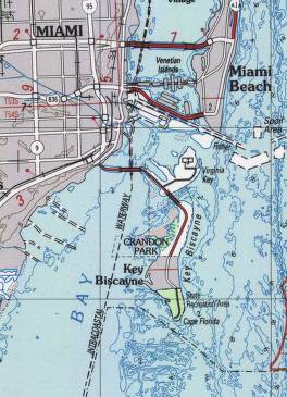
Key Biscayne lies south of Miami Beach and east of Miami. The village is connected to Miami via the Rickenbacker Causeway, originally built in 1947. Because of its low elevation and direct exposure to the Atlantic Ocean, it is usually among the first Miami areas to be evacuated before an oncoming hurricane.

According to the U.S. Census Bureau, the town has an area of 1.7 square miles (4.4 km2), of which 1.2 square miles (3.1 km2) is land and 0.5 square miles (1 km2) (27.0%) is water. [1] The village is bordered on the north by Crandon Park, a Miami-Dade County park; on the south by Bill Baggs Cape Florida State Park; on the east by the Atlantic Ocean; and on the west by Biscayne Bay.

History

Rickenbacker Causeway

U.S. President Richard Nixon at Key Biscayne's Fourth of July parade in 1969; as president, Nixon visited his Key Biscayne compound over 50 times. President Richard Nixon Greeting Children on the Crandon Boulevard Fourth of July Parade Route in Key Biscayne, Florida.jpg
U.S. President Richard Nixon at Key Biscayne's Fourth of July parade in 1969; as president, Nixon visited his Key Biscayne compound over 50 times.

While there had been earlier plans to develop a town on Key Biscayne, the opening of the 4-mile-long (6.4 km) Rickenbacker Causeway from Miami to Virginia Key and on to Key Biscayne in 1947 opened the island up to large-scale residential development. The northern two-thirds of the island had operated as the largest coconut plantation in the continental United States during the first half of the 20th century.

In 1940, the Matheson family donated over 800 acres (3.2 km2) of their land to Dade County for a public park, which became Crandon Park, in exchange for a commitment from the county that it would build a causeway to the island. The remaining Matheson property, stretching across the middle of the island, was sold to developers. Beginning in 1951, the Mackle Construction Company offered new homes on the island for $9,540, with $500 down. A U.S. Post Office branch opened in Key Biscayne, the Community Church started holding services in an old coconut-husking shed, and Key Biscayne Elementary School opened in 1952. [6]

The island's southern third, which included Cape Florida, was owned by James Deering, and, after his death, by his brother Charles, for 35 years. In 1948, José Manuel Áleman, a Cuban politician in exile, bought the Cape Florida property from the Deering estate. After Áleman died in 1951, his widow, Elena Santeiro Garcia, added to the property, purchasing an ocean-to-bay strip that had been part of the Matheson property. This strip included a canal William Matheson dug in the 1920s that extended from the bay across most of the island. The land north of the canal was developed as part of what is now the Village of Key Biscayne. In 1966, Garcia sold the Cape Florida property to the state of Florida, and the property became Bill Baggs Cape Florida State Park, which opened January 1, 1967. [7]

Richard Nixon compound

In 1969, U.S. President Richard Nixon purchased the first of his three waterfront homes, forming a compound known as the Florida White House, to be near his close friend and confidant Bebe Rebozo, owner of Key Biscayne Bank, and industrialist Robert Abplanalp, inventor of the modern spray can valve. Rebozo was indicted for laundering a $100,000 donation from Howard Hughes to Nixon's election campaign. Presidents Kennedy and Nixon met for the first time after Nixon's 1960 presidential campaign defeat in an oceanfront villa at the old Key Biscayne Hotel.

Plans for the break-in at the Democratic National Committee headquarters in the Watergate complex were discussed at Nixon's Key Biscayne compound and, as the Watergate scandal unfolded, Nixon retreated into seclusion there with greater regularity. Between 1969 and 1973, he visited Key Biscayne over 50 times. The U.S. Department of Defense spent $400,000 constructing a helicopter landing pad in Biscayne Bay adjacent to his compound; when Nixon later sold the property, including the helicopter pad, there were public accusations that he had enriched himself at taxpayer expense.[ citation needed ]

Incorporation

The area was incorporated as a new municipality in 1991, making it the first new city in Miami-Dade County in over 50 years. Rafael Conte was elected the first mayor, along with the members of the founding village council: Clifford Brody, Mortimer Fried, Michael Hill, Bautista Tedin, Lucas Keller, Luis Lauredo, Joe Rasco, and Raymond Sullivan. The municipality's first manager was C. Samuel Kissinger and the first clerk was Guido Inguanzo. The village's incorporation, overseen by Alfred Brewer, provided local control over taxes and future development.[ citation needed ]

Key Biscayne is a small, intimate community. Most families that live there have known each other for generations. Children who grew up on the island are sometimes referred to as "Key Rats". [8]

Hurricane Andrew

In 1992, Hurricane Andrew flooded some homes and businesses on Key Biscayne, impacting insurance. [9] The eye wall passed over uninhabited Bill Baggs Cape Florida State Park, which received the brunt of the storm. The damage was a blessing for the park because it destroyed all the non-native vegetation the state had been trying to eradicate. Federal and state funding allowed the replanting with native vegetation, making the park a showplace natural area. The town is in Evacuation Zone A. [10]

In 2017, a study found that the town could be partly flooded at high tides by 2045 after sea-level rise. [11] Property values fell.

In November 2020, the town voted to approve a $100 million bond to protect itself. [12]

The village has its own fire, police and public elementary and middle school. The millage tax rate remains one of the lowest of any municipality in Miami-Dade County. In 2004, the village completed the construction of a civic center, including fire, police and administration buildings and a recreation and community center with indoor multi-use courts, an outdoor swimming pool, and a musical theater program.[ citation needed ]

Climate

Key Biscayne has a tropical monsoon climate (Am). Key Biscayne experiences hot, humid summers and warm, dry winters. The island is in USDA plant zone 11a. Due to its island location, Key Biscayne is subject to cooler highs than Miami year-round. Hurricanes threaten the island occasionally, though landfalls are rare. Precipitation is lower than that of Miami, as the Atlantic Ocean inhibits summer thunderstorm convection.

Climate data for Cape Florida (19912020 normals, extremes 1999present)
MonthJanFebMarAprMayJunJulAugSepOctNovDecYear
Record high °F (°C)87
(31)
87
(31)
90
(32)
96
(36)
93
(34)
96
(36)
96
(36)
96
(36)
95
(35)
93
(34)
90
(32)
88
(31)
96
(36)
Mean maximum °F (°C)83.3
(28.5)
83.3
(28.5)
85.9
(29.9)
88.7
(31.5)
88.9
(31.6)
92.0
(33.3)
92.6
(33.7)
92.4
(33.6)
92.1
(33.4)
90.5
(32.5)
86.5
(30.3)
84.3
(29.1)
93.9
(34.4)
Mean daily maximum °F (°C)77.5
(25.3)
78.9
(26.1)
80.9
(27.2)
83.8
(28.8)
86.5
(30.3)
89.6
(32.0)
90.8
(32.7)
91.4
(33.0)
90.3
(32.4)
87.2
(30.7)
82.7
(28.2)
79.7
(26.5)
84.9
(29.4)
Daily mean °F (°C)70.1
(21.2)
71.8
(22.1)
74.0
(23.3)
77.6
(25.3)
80.7
(27.1)
83.8
(28.8)
84.9
(29.4)
85.4
(29.7)
84.5
(29.2)
81.6
(27.6)
76.7
(24.8)
72.9
(22.7)
78.7
(25.9)
Mean daily minimum °F (°C)62.8
(17.1)
64.8
(18.2)
67.1
(19.5)
71.5
(21.9)
74.9
(23.8)
78.0
(25.6)
79.0
(26.1)
79.4
(26.3)
78.7
(25.9)
76.1
(24.5)
70.7
(21.5)
66.0
(18.9)
72.4
(22.4)
Mean minimum °F (°C)44.5
(6.9)
48.1
(8.9)
52.6
(11.4)
60.2
(15.7)
67.0
(19.4)
71.9
(22.2)
73.9
(23.3)
74.4
(23.6)
74.0
(23.3)
65.2
(18.4)
56.3
(13.5)
50.7
(10.4)
41.7
(5.4)
Record low °F (°C)35
(2)
38
(3)
44
(7)
49
(9)
61
(16)
64
(18)
71
(22)
71
(22)
66
(19)
54
(12)
45
(7)
37
(3)
35
(2)
Average precipitation inches (mm)2.44
(62)
2.00
(51)
2.37
(60)
3.17
(81)
5.67
(144)
7.37
(187)
5.64
(143)
7.05
(179)
7.54
(192)
6.33
(161)
3.51
(89)
2.24
(57)
55.33
(1,406)
Average precipitation days (≥ 0.01 in)7.96.56.36.19.914.814.915.815.312.89.08.0127.3
Source: NOAA (mean maxima/minima 20062020) [13] [14]

Demographics

The beach at Crandon Park in Key Biscayne in February 2008 Crandon Park beach, FL.jpg
The beach at Crandon Park in Key Biscayne in February 2008
Historical population
CensusPop.Note
2000 10,507
2010 12,34417.5%
2020 14,80920.0%
U.S. Decennial Census [15]

2020 census

Key Biscayne racial composition
(Hispanics excluded from racial categories)
(NH = Non-Hispanic) [16]
RaceNumberPercentage
White (NH)3,97926.87%
Black or African American (NH)270.18%
Native American or Alaska Native (NH)30.02%
Asian (NH)1060.72%
Pacific Islander or Native Hawaiian (NH)00.00%
Some other race (NH)870.59%
Two or more races/Multiracial (NH)7194.86%
Hispanic or Latino (any race)9,88866.77%
Total14,809

As of the 2020 U.S. census, there were 14,809 people, 4,058 households, and 3,174 families residing in the village. [17]

2010 census

Key Biscayne Demographics
2010 census Key BiscayneMiami-Dade CountyFlorida
Total population12,3442,496,43518,801,310
Population, percent change, 2000 to 2010+17.5%+10.8%+17.6%
Population density10,070.7/sq mi1,315.5/sq mi350.6/sq mi
White or Caucasian (including White Hispanic)96.2%73.8%75.0%
(Non-Hispanic White or Caucasian)36.5%15.4%57.9%
Black or African-American 0.4%18.9%16.0%
Hispanic or Latino (of any race) 61.6%65.0%22.5%
Asian 1.1%1.5%2.4%
Native American or Native Alaskan 0.1%0.2%0.4%
Pacific Islander or Native Hawaiian 0.0%0.0%0.1%
Two or more races (Multiracial) 1.2%2.4%2.5%
Some Other Race 1.0%3.2%3.6%

As of the 2010 U.S. census, there were 12,344 people, 4,256 households, and 2,976 families residing in the village. [18]

2000 census

In 2000, 32.3% had children under the age of 18 living with them, 58.0% were married couples living together, 7.7% had a female householder with no husband present, and 31.9% were non-families. 27.9% of all households were made up of individuals, and 9.5% had someone living alone who was 65 years of age or older. The average household size was 2.47 and the average family size was 2.99.

In 2000, 24.2% under the age of 18, 4.6% from 18 to 24, 29.6% from 25 to 44, 26.0% from 45 to 64, and 15.6% who were 65 years of age or older. The median age was 40 years. For every 100 females, there were 88.4 males. For every 100 females age 18 and over, there were 84.8 males.

In 2000, the median income for a household in the village was $86,599, and the median income for a family was $107,610. Males had a median income of $86,322 versus $46,765 for females. The per capita income for the village was $54,213.

As of 2000, 59.73% of residents spoke Spanish at home, while 30.84% spoke only English. Speakers of Portuguese were 2.83%, French 2.67%, Italian 1.67%, and German 1.47% of the population. [19]

Media

The Islander News is a weekly community newspaper serving Key Biscayne. The estimated circulation in 2020 was 3,600. [20] [21]

Key Biscayne Magazine is a lifestyle magazine published in Miami by TAG Media, publishers of Brickell Magazine . The circulation of the magazine was about 10,000 in 2020. [22] [23]

Education

Key Biscayne Community School KeyBiscayneCommunitySchool.JPG
Key Biscayne Community School

Miami-Dade County Public Schools serves Key Biscayne. The Key Biscayne K–8 Center serves Key Biscayne. [24] [25] Middle school students may attend Ponce de Leon Middle School in Coral Gables instead of the Key Biscayne School. [26] High school students are zoned to Coral Gables Senior High School. [27] [28]

MAST Academy, a magnet school on Virginia Key, has since 2012 given eligible Key Biscayne residents priority in filling 1,100 seats in the school's Cambridge program. [28] [29]

The Miami-Dade Public Library System operates the 6,000-square-foot (560 m2) Key Biscayne Branch Library. It opened in January 1985. [30]

St. Agnes Academy is a Catholic private school at 122 Harbor Drive, of the Roman Catholic Archdiocese of Miami. It serves pre-K–8th grade.

Notable people

Hotels and condominiums controversy

As noted above, the construction of several condominium complexes in Key Biscayne caused the population to soar. In 2007, voters approved an amendment to the village charter requiring that future land use changes be approved by voters. In 2008, the village council, saying that requiring community voting on zoning changes infringed on its responsibility, submitted another proposal to revise the charter. But on November 4, 2008, voters overwhelmingly rejected the council's proposed change, defeating the amendment by a more than two-to-one margin. [40] [41]

Other information

Key Biscayne hosts the Tennis Center at Crandon Park, former home to the Miami Open Tennis Tournament, and a golf course, along with many amenities for water sports and fishing.

Key Biscayne has a visitors center, open 24/7, 365 days a year, in the Village Hall, 88 West McIntyre Street #100, next to the police station. Staffed M–F from 9am to 5pm

Related Research Articles

<span class="mw-page-title-main">Bay Harbor Islands, Florida</span> Town in Florida

Bay Harbor Islands is a town in Miami-Dade County, Florida, United States. The city is part of the Miami metropolitan area of South Florida. It is separated from the mainland by Biscayne Bay. The population was 5,922 at the 2020 US census.

<span class="mw-page-title-main">Fisher Island, Florida</span> Census-designated place in Florida

Fisher Island is a census-designated place in Miami-Dade County, Florida, United States, located on a barrier island of the same name. Since 2015, Fisher Island has the highest per capita income of any place in the United States. It is located in the Miami metropolitan area of South Florida. As of the 2020 census, the population was 561.

<span class="mw-page-title-main">Indian Creek, Florida</span> Village in Florida

Indian Creek is a village, gated community, and man-made barrier island in Miami-Dade County, Florida, United States. It has 41 residential home sites and the Indian Creek Country Club. The village is part of the Miami metropolitan area of South Florida. The concentration of highly affluent people on the island has earned it the nickname "Billionaire Bunker". The population was 84 at the 2020 census. All the waterfront homes surround the Indian Creek country club and golf course, which takes up most of the land on the island. Residents of the island are said to have access to the country club which is said to very exclusive, though not all of them are members of the country club. The village has its own government and law enforcement.

<span class="mw-page-title-main">Islandia, Florida</span> Unincorporated community in Florida, United States

Islandia is an unincorporated community and former city in Miami-Dade County, Florida, United States. It is located in the upper Florida Keys on the islands of Elliott Key and other nearby keys, such as Totten Key. It was the only municipality in the Florida Keys not located in neighboring Monroe County. The population was 18 at the 2010 Census. Most residents of the city were National Park Service employees.

<span class="mw-page-title-main">Miami Shores, Florida</span> Village in Florida

Miami Shores or Miami Shores Village is a village in Miami-Dade County, Florida. The village is part of the Miami metropolitan area of South Florida. As of the 2020 census, the population was 11,567, up from 10,493 in 2010.

<span class="mw-page-title-main">North Bay Village, Florida</span> City in Florida

North Bay Village is a city located in Miami-Dade County, Florida. The city is part of the Miami metropolitan area of South Florida. As of the 2020 census, the city had a total population of 8,159.

<span class="mw-page-title-main">North Miami, Florida</span> City in Florida

North Miami is a suburban city located in northeast Miami-Dade County, Florida, United States, about 10 miles (16 km) north of Miami. The city lies on Biscayne Bay and hosts the Biscayne Bay Campus of Florida International University.. Originally the "Town of Arch Creek", the area was incorporated as the "Town of Miami Shores", which was renamed the "Town of North Miami" in 1931. It was reincorporated as a city in 1953. The city is part of the Miami metropolitan area of South Florida.

<span class="mw-page-title-main">Coconut Grove</span> Neighborhood of Miami, Florida, United States

Coconut Grove, also known colloquially as “The Grove,” is an affluent and the oldest continuously inhabited neighborhood of Miami in Miami-Dade County, Florida. The neighborhood is roughly bounded by North Prospect Drive to the south, LeJeune Road to the west, South Dixie Highway and Rickenbacker Causeway to the north, and Biscayne Bay to the east. It is south of the neighborhoods of Brickell and The Roads and east of Coral Gables. The neighborhood's name has been sometimes spelled "Cocoanut Grove" but the definitive spelling "Coconut Grove" was established when the city was incorporated in 1919.

<span class="mw-page-title-main">Biscayne Bay</span> Florida lagoon

Biscayne Bay is a lagoon with characteristics of an estuary located on the Atlantic coast of South Florida. The northern end of the lagoon is surrounded by the densely developed heart of the Miami metropolitan area while the southern end is largely undeveloped with a large portion of the lagoon included in Biscayne National Park.

<span class="mw-page-title-main">Key Biscayne</span> Island in Florida, United States

Key Biscayne is an island located in Miami-Dade County, Florida, located between the Atlantic Ocean and Biscayne Bay. It is the southernmost of the barrier islands along the Atlantic coast of Florida, and lies south of Miami Beach and southeast of Miami. The key is connected to Miami via the Rickenbacker Causeway, originally built in 1947.

<span class="mw-page-title-main">Miami metropolitan area</span> Metropolis in the U.S. state of Florida

The Miami metropolitan area, also known as South Florida, SoFlo, SoFla, the Gold Coast, the Tri-County Area, or Greater Miami, and officially the Miami–Fort Lauderdale–West Palm Beach Metropolitan Statistical Area, is a coastal metropolitan area in southeastern Florida. It is the ninth-largest metropolitan statistical area (MSA) in the United States, the fifth-largest metropolitan area in the Southern United States, and the largest metropolitan area in Florida. With a population of 6.18 million, its population exceeds 31 of the nation's 50 states as of 2023. It comprises the three most populated counties in the state, Miami-Dade County, Broward County, and Palm Beach County, which rank as the first, second, and third-most populous counties in the state, respectively. Miami-Dade County, with 2,701,767 people in 2020, is the seventh-most populous county in the United States.

<span class="mw-page-title-main">Virginia Key</span> Neighborhood of Miami in Miami-Dade County, Florida, United States

Virginia Key is an 863-acre (3.49 km2) barrier island in Miami, Florida. It is located in Biscayne Bay south of Brickell and north of Key Biscayne and is accessible from the mainland via the Rickenbacker Causeway.

<span class="mw-page-title-main">Florida State Road 913</span> State highway in Florida, United States

State Road 913 is an access road between the village of Key Biscayne on the island of Key Biscayne and I-95 in Miami on the western end of Biscayne Bay.

<span class="mw-page-title-main">Rickenbacker Causeway</span> Bridge in Florida, United States of America

The Rickenbacker Causeway is a causeway that connects Miami, Florida to the barrier islands of Virginia Key and Key Biscayne across Biscayne Bay.

<span class="mw-page-title-main">Brickell</span> Neighborhood of Miami in Miami-Dade County, Florida, United States

Brickell is a neighborhood in Miami, Florida, historically referenced at times as Southside, located directly east of Interstate 95, south of the Miami River and north of Coconut Grove. Brickell is known as the financial district of Miami, as well as South Florida.

<span class="mw-page-title-main">Greater Downtown Miami</span> Neighborhood in Miami-Dade County, Florida, United States

Downtown Miami is the urban city center of Miami, Florida, United States. The city's greater downtown region consists of the Central Business District, Brickell, the Historic District, Government Center, the Arts & Entertainment District, and Park West. It is divided by the Miami River and is bordered by Midtown Miami's Edgewater, and Wynwood sections to its north, Biscayne Bay to its east, the Health District and Overtown to its west, and Coconut Grove to its south.

William John Matheson (1856–1930) was an American industrialist. Born in Wisconsin, he was educated in Scotland where he learned about recent breakthroughs in the development of aniline dyes. Matheson became an early importer and distributor of such dyes from Germany.

<span class="mw-page-title-main">Crandon Park</span> Public park in Florida, US

Crandon Park is an 808-acre (3.27 km2) urban park in metropolitan Miami, occupying the northern part of Key Biscayne. It is connected to mainland Miami via the Rickenbacker Causeway.

<span class="mw-page-title-main">Haulover Park</span> Public park in Florida, US

Haulover Park is a 177-acre (72 ha) urban park owned and operated by Miami-Dade County Parks, Recreation & Open Spaces Department, located in metropolitan Miami, just north of Bal Harbour, Florida. The park is located on a shoal between the Atlantic Ocean and Biscayne Bay, just north of the Broad Causeway and Collins Avenue.

<span class="mw-page-title-main">Miami-Dade County, Florida</span> County in Florida, United States

Miami-Dade County is a county located in the southeastern part of the U.S. state of Florida. The county had a population of 2,701,767 as of the 2020 census, making it the most populous county in Florida and the seventh-most populous county in the United States. It is Florida's third largest county in terms of land area with 1,946 square miles (5,040 km2). The county seat is Miami, the core of the nation's ninth-largest and world's 65th-largest metropolitan area with a 2020 population of 6.138 million people, exceeding the population of 31 of the nation's 50 states as of 2022.

References

  1. 1 2 "2022 U.S. Gazetteer Files: Florida". United States Census Bureau. Retrieved January 3, 2023.
  2. 1 2 "P1. Race – Key Biscayne village, Florida: 2020 DEC Redistricting Data (PL 94-171)". U.S. Census Bureau. Retrieved January 3, 2023.
  3. "U.S. Census website". United States Census Bureau . Retrieved January 31, 2008.
  4. "US Board on Geographic Names". United States Geological Survey. October 25, 2007. Retrieved January 31, 2008.
  5. "P1. Race – Biscayne village, Florida: 2010 DEC Redistricting Data (PL 94-171)". U.S. Census Bureau. Retrieved January 3, 2023.
  6. Blank. pp. 159-162.
  7. Blank. pp.166-171.
  8. "Tale of a Key Rat: The Michael Capponi story". The Miami Herald .
  9. Adrian Sainz (August 24, 2002). "Ten years after Hurricane Andrew, effects are still felt". South Florida Sun-Sentinel . Miami, Florida. Associated Press. Archived from the original on October 14, 2012. Retrieved May 8, 2012.
  10. "Flood Information and Protection". keybiscayne.fl.gov. Archived from the original on November 4, 2020.
  11. "Village of Key Biscayne final vulnerability assessment" (PDF). 2017. Archived from the original (PDF) on November 4, 2020. by 2045, if no adaptation steps are taken, most roads within the village will experience tidal flooding during king tides, as will many low-lying residential and commercial properties.
  12. Harris, Alex (November 3, 2020). "Key Biscayne votes to spend $100 million to protect itself from sea-level rise". Miami Herald . Archived from the original on November 4, 2020.
  13. "NOWData – NOAA Online Weather Data". National Oceanic and Atmospheric Administration . Retrieved February 20, 2023.
  14. "Summary of Monthly Normals 1991-2020". National Oceanic and Atmospheric Administration . Retrieved February 20, 2023.
  15. "Census of Population and Housing". Census.gov. Retrieved June 4, 2015.
  16. "Explore Census Data". data.census.gov. Retrieved February 9, 2022.
  17. "S1101 HOUSEHOLDS AND FAMILIES - 2020: Key Biscayne city, Florida". United States Census Bureau .
  18. "S1101 HOUSEHOLDS AND FAMILIES - 2010: Key Biscayne city, Florida". United States Census Bureau .
  19. "MLA Data Center Results of Key Biscayne, FL". Modern Language Association . Retrieved November 1, 2007.
  20. "Key Biscayne Islander News". Mondotimes. 2021. Retrieved August 7, 2021.
  21. "About Us". Islander Media Group. 2021. Retrieved August 7, 2021.
  22. "About Us". Magazine Key Biscayne. Retrieved August 7, 2021.
  23. "Key Biscayne Advertising – Magazine Advertising Costs". Resources for Entrepreneurs. 2021.
  24. "Key Biscayne K-8 Center". keybiscayne.dadeschools.net. Retrieved June 13, 2018.
  25. "KEY BISCAYNE K-8 CENTER School Legal Boundaries Description." Miami-Dade County Public Schools. Retrieved on April 25, 2013.
  26. "PONCE DE LEON MS School Legal Boundaries Description." Miami-Dade County Public Schools. Retrieved on April 25, 2013.
  27. "Coral Gables SHS School Legal Boundaries Description." Miami-Dade County Public Schools. Retrieved on April 25, 2013.
  28. 1 2 "MAST Academy about to be expanded for Key Biscayne students." Miami Herald . June 13, 2013. Retrieved on April 26, 2013.
  29. Josephson, Kelly (May 12, 2017). "School district adds 22 6th-grade seats at MAST Academy". The Islander News. Retrieved February 26, 2019.
  30. "Key Biscayne Branch." Miami-Dade Public Library System. Retrieved on April 27, 2013.
  31. "THE CHER HOUSE". Key Biscayne Magazine. July 13, 2018. Retrieved December 13, 2019.
  32. Cubilla, Rachel (November 29, 2018). "Fittipaldi Family". Key Biscayne Magazine. Retrieved December 13, 2019.
  33. Wadler, Joyce (April 27, 2006). "The Soul of Havana on Biscayne Bay". The New York Times. ISSN   0362-4331 . Retrieved December 13, 2019.
  34. Coffee, Rod. "Key Biscayne music man headlines Coconut Grove's festival this weekend". IslanderNews.com. Retrieved December 13, 2019.
  35. "Village of Key Biscayne, FL". keybiscayne.fl.gov. Retrieved May 15, 2022.
  36. "Council of American Ambassadors". Council of American Ambassadors. Retrieved May 15, 2022.
  37. Pogrebin, Robin (December 6, 2015). "In a Red-Hot Art Market, the Collector Martin Margulies Stays Cool". The New York Times. ISSN   0362-4331 . Retrieved December 13, 2019.
  38. "Nixon presidential retreat in Key Biscayne torn down". Sarasota Herald-Tribune. Associated Press. Retrieved December 13, 2019.
  39. Pearson, Richard (May 10, 1998). "Charles 'Bebe' Rebozo, 85, Dies". The Washington Post. Archived from the original on August 19, 2000. Retrieved December 13, 2019.
  40. Key Biscayne Ordinance setting referendum Archived July 21, 2011, at the Wayback Machine Retrieved November 1, 2008
  41. The Miami Herald, November 5, 2008

Further reading