Beckfoot railway station

Last updated

Beckfoot Halt
Station on heritage railway
Beckfoot Station - geograph.org.uk - 1338391.jpg
Beckfoot railway station sign
General information
Location Eskdale, Cumbria
England
Coordinates 54°23′35″N3°16′59″W / 54.393°N 3.283°W / 54.393; -3.283
Grid reference NY 168 004
Owned by R&ER
Operated by R&ER
Managed by R&ER
Platforms1
Key dates
1876Opened (3 ft gauge)
1913Station closed
1916Reopened (15 in gauge
Ravenglass &
Eskdale Railway
BSicon CONTg.svg
BSicon udENDEa.svg
BSicon dSTR.svg
Headshunt
0 mi 0 ch
0 km
BSicon lDRH.svg
BSicon uSTR~L.svg
BSicon uKSTRa.svg
BSicon STR.svg
BSicon uSTR~R.svg
Turntable
BSicon udSTR.svg
BSicon ulv-DST@F.svg
BSicon uv-SHI2gr.G.svg
BSicon dSTR.svg
Workshop
BSicon HUB2.svg
BSicon uINTACC.svg
BSicon HUBc3.svg
BSicon STR.svg
Ravenglass BSicon PARKING.svg
0 mi 3 ch
0.06 km
BSicon HUBc1.svg
BSicon uSTR.svg
BSicon HUB4.svg
BSicon INTACC.svg
Ravenglass National Rail logo.svg
BSicon uSTR.svg
BSicon CONT2+g.svg
BSicon uSKRZ-G2o.svg
Ravenglass Main Street
BSicon uv-SHI2g+r.F.svg
BSicon ulvDST@G-.svg
BSicon ulv-DST@F.svg
BSicon uvSHI2gl.G-.svg
Engine & carriage sheds
BSicon uSTR.svg
BSicon LOCK3u.svg
(1 in 48)
BSicon uSKRZ-GDu.svg
Black Bridge
BSicon uKMW.svg
1 mi 0 ch
1.61 km
BSicon uSKRZ-G2u.svg
BSicon uHST.svg
Muncaster Mill BSicon PARKING.svg
1 mi 6 ch
1.73 km
BSicon uhbKRZWae.svg
Mill Race
BSicon uSTR.svg
BSicon LOCK3d.svg
Mill Wood Bank (1 in 43)
BSicon uHST.svg
Miteside Halt
1 mi 49 ch
2.6 km
BSicon uPSL.svg
Miteside Loop
1 mi 67 ch
2.96 km
BSicon uKMW.svg
2 mi 0 ch
3.22 km
BSicon uSTRo.svg
Katie Caddy Bridge
BSicon uCSTRae.svg
Wet Cutting
BSicon uPSLra.svg
Murthwaite Siding
2 mi 43 ch
4.08 km
BSicon uSTR.svg
BSicon LOCK3d.svg
Murthwaite Oak Tree (1 in 43)
BSicon uexKBSTaq.svg
BSicon ueABZg+r.svg
Murthwaite Quarry
BSicon uHST.svg
Murthwaite Halt
2 mi 55 ch
4.33 km
BSicon uKMW.svg
3 mi 0 ch
4.83 km
BSicon uSTR.svg
BSicon LOCK3d.svg
(1 in 40)
BSicon uGIPl.svg
Walk Mill Summit
BSicon uSTR.svg
BSicon LOCK3u.svg
(1 in 51)
BSicon uSBRUCKE.svg
Black Bridge (derelict)
BSicon uKMW.svg
4 mi 0 ch
6.44 km
BSicon uACC.svg
Irton Road BSicon PARKING.svg
4 mi 8 ch
6.6 km
BSicon uhbKRZWae.svg
Mere Beck
BSicon uACC.svg
The Green BSicon PARKING.svg
4 mi 59 ch
7.62 km
BSicon uSKRZ-G1u.svg
Eskdale Valley Road
BSicon uSTR.svg
BSicon LOCK3d.svg
Hollin How Bank (1 in 43)
BSicon uKMW.svg
5 mi 0 ch
8.05 km
BSicon uSKRZ-GDu.svg
Hollin How Bridge
BSicon uGIPl.svg
Hollin How Summit
BSicon ueABZgl.svg
BSicon uexKBSTeq.svg
Fisherground Incline
BSicon uSTR.svg
BSicon LOCK3d.svg
(1 in 55)
BSicon uPSL.svg
Fisherground Loop
5 mi 28 ch
8.61 km
BSicon uHST.svg
Fisherground
5 mi 35 ch
8.75 km
BSicon ueABZgl.svg
BSicon uexKBSTeq.svg
Ban Garth Incline
BSicon uSTR.svg
BSicon LOCK3d.svg
Spout House Curve (1 in 52)
BSicon uSKRZ-GDu.svg
Spout House Bridge
BSicon uCSTRae.svg
Gilbert's Cutting
BSicon uKMW.svg
6 mi 0 ch
9.66 km
BSicon ueABZgl.svg
BSicon uexKBSTeq.svg
Beckfoot Quarry
BSicon uSTR.svg
BSicon LOCK3d.svg
(1 in 67)
BSicon uHST.svg
Beckfoot BSicon PARKING.svg
6 mi 30 ch
10.26 km
BSicon uSTR.svg
BSicon LOCK3d.svg
Beckfoot Bank (1 in 53)
BSicon ueABZg2.svg
BSicon uexSTRc3.svg
Ghyll Force Junction
BSicon ueSTR+c1.svg
BSicon uexKHST4.svg
Boot
BSicon uGIPl.svg
Beckfoot Summit
BSicon ueHST.svg
Dalegarth Cottages
BSicon uhbKRZWae.svg
BSicon uACC.svg
Dalegarth BSicon PARKING.svg
6 mi 68 ch
11.02 km
BSicon lDRH.svg
BSicon uKSTRxe.svg
Turntable
BSicon uexKBSTe.svg

Beckfoot railway station is a railway station on the 15" gauge Ravenglass & Eskdale Railway in the English county of Cumbria. It is situated in the civil parish of Eskdale and the Lake District National Park, and is within a 12 mile (0.80 km) walk of the eastern terminus of the line, at Dalegarth station. [1]

Contents

The station opened to passengers in 1876. In the days of the 3 ft gauge railway, this was the last place where the railway met the main valley road, and as such had a greater number of facilities than other stations, including a goods yard and shed, and a chocolate vending machine in the waiting shelter.

Between 1918 and 1922, Beckfoot was the upper terminus of the railway prior to the extension of the line to the present terminus at Dalegarth. The original station building survived for some time into the 15 inch gauge era, but had been demolished by the time the preservationists took over in 1960.

The station is unstaffed at all times, and is only 20 metres (66 ft) long. It can be accessed either by steps or from, the road which crosses the line, east of the station. It differs from the other stations in that passengers will only be picked up here on down journeys (Dalegarth-Ravenglass) and will only be set down here on up journeys (Ravenglass-Dalegarth). This is because the station is close to Dalegarth, and to save stopping for passengers completing very short journeys. There is a level crossing at the eastern end of the platform, marking the beginning of the private road from Beckfoot to Dalegarth cottages which runs for half a mile eastwards. This road is known as Beckfoot Lonnin and walkers can continue behind the Cottages at the end of the Lonnin up to the original 3' gauge railway station at Boot village.[ citation needed ]

The station is 6.5 miles (10.5 km) from Ravenglass and 12 mile (0.80 km) from Dalegarth.

Accessibility

Due to the length of the platform, the railway are unable to accommodate wheelchair passengers, for health & safety reasons.[ citation needed ]

Related Research Articles

<span class="mw-page-title-main">Ravenglass and Eskdale Railway</span> Heritage railway in Cumbria, England

The Ravenglass and Eskdale Railway is a 15 in minimum gauge heritage railway in Cumbria, England. The 7-mile (11.3 km) line runs from Ravenglass to Dalegarth Station near Boot in the valley of Eskdale, in the Lake District. At Ravenglass the line ends at Ravenglass railway station on the Cumbrian Coast Line.

Originally called the Commercial Railway, the London and Blackwall Railway (L&BR) in east London, England, ran from Minories to Blackwall via Stepney, with a branch line to the Isle of Dogs, connecting central London to many of London's docks. It was operational from 1840 until 1926 and 1968, closing after the decline of inner London's docks. Much of its infrastructure was reused as part of the Docklands Light Railway. The L&BR was leased by the Great Eastern Railway in 1866, but remained independent until absorbed into the London and North Eastern Railway at the 1923 Grouping. Another branch was opened in 1871, the Millwall Extension Railway.

<span class="mw-page-title-main">Campbeltown and Machrihanish Light Railway</span> Former railway line in Scotland

The Campbeltown and Machrihanish Light Railway was a 2 ft 3 in narrow gauge railway in Kintyre, Scotland, between Campbeltown and the coalmining village of Machrihanish. Only three other passenger-carrying lines in the UK operated on the same gauge, all of them in Wales - the Corris Railway, the short-lived Plynlimon and Hafan Tramway and the Talyllyn Railway.

<span class="mw-page-title-main">Ravenglass railway station</span> Railway station in Cumbria, England

Ravenglass is a railway station on the Cumbrian Coast Line, which runs between Carlisle and Barrow-in-Furness. The station, situated 29+14 miles (47 km) north-west of Barrow-in-Furness, serves the village of Ravenglass in Cumbria. It is owned by Network Rail and managed by Northern Trains.

<span class="mw-page-title-main">Duffield Bank Railway</span> Narrow-gauge railway in Derbyshire, England

The Duffield Bank Railway was built by Sir Arthur Percival Heywood in the grounds of his house on a hillside overlooking Duffield, Derbyshire in 1874. Although the Ordnance Survey map circa 1880 does not show the railway itself, it does show two tunnels and two signal posts. However, the online map archive of the National Library of Scotland includes a map of 1914 from the 25 inches to the foot series that shows the full extent of the railway.

<span class="mw-page-title-main">Boot, Cumbria</span> Village in the English county of Cumbria

Boot is a small village in Eskdale on the western side of the English Lake District. It lies within the civil parish of Eskdale, the unitary authority of Cumberland, and the ceremonial county of Cumbria. The main part of the village lies beside the Whillan Beck, whilst its church, St Catherine's, lies 0.6 miles (0.97 km) to the south on the bank of the River Esk. The Whillan Beck flows into the Esk just downstream of the village.

<span class="mw-page-title-main">Jersey Railway</span> Former railway line in Jersey

The Jersey Railway was opened in 1870 and was originally a standard gauge railway, 3+34 miles (6.0 km) long, in Jersey in the Channel Islands. Converted to narrow gauge in 1884 and extended giving a length of 7+34 miles (12.5 km), the line closed in 1936.

<span class="mw-page-title-main">Irton Road railway station</span>

Irton Road railway station is a railway station on the 15 in gauge Ravenglass & Eskdale Railway in the Lake District National Park and the English county of Cumbria. The station is situated on the western edge of the village of Eskdale Green. It is some 4 miles (6.4 km) from Ravenglass and 3 miles (4.8 km) from Dalegarth for Boot, and trains take 20 minutes to reach their destinations in either direction from this station.

<span class="mw-page-title-main">The Green railway station</span> Station on the Ravenglass & Eskdale Railway, Cumbria, England

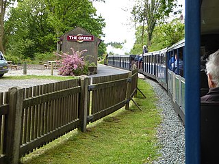
The Green is a railway station on the 15-inch gauge Ravenglass & Eskdale Railway in the Lake District National Park and the English county of Cumbria. The station is situated on the southern edge of the village of Eskdale Green, overlooking the Eskdale valley and Muncaster Fell. It was originally known as King of Prussia after the nearby public house, and later as Eskdale Green. The Eskdale Green name has continued in popular use, and was still in official use in 2017 in the railway's "full" timetable of intermediate stopping places.

<span class="mw-page-title-main">Murthwaite Halt railway station</span>

Murthwaite Halt railway station is a small intermediate railway station on the 15" gauge Ravenglass & Eskdale Railway in Cumbria, England. It is named after the farm that stood in the field opposite the railway.

<span class="mw-page-title-main">Muncaster Mill railway station</span>

Muncaster Mill railway station is a railway station on the 15 in gauge Ravenglass & Eskdale Railway in Cumbria, England. The station is located 1 mile (1.6 km) from Ravenglass and 6 miles (9.7 km) from Dalegarth, at the point where the A595 coast road crosses the line. It is situated on the bank of the River Mite and adjacent to Muncaster Mill, formerly a watermill but now a private house, from which it takes its name.

<span class="mw-page-title-main">Ravenglass (R&ER) railway station</span>

Ravenglass Heritage Railway Station is the Western terminus of the Ravenglass and Eskdale Railway. It is situated to the east of Ravenglass main line railway station, which is on the Cumbrian Coast Line. The facilities at the railway station include toilets, under-cover platforms, booking office and café. The railway station complex incorporates 2 locomotive sheds, a carriage shed, a signal box, managerial offices and 2 camping coaches; along with the railway station itself.

<span class="mw-page-title-main">Fisherground railway station</span>

Fisherground railway station, also known as Fisherground Halt, is on the 15-inch (380 mm) gauge Ravenglass & Eskdale Railway in Cumbria, England. Its main purpose is to serve the adjoining camp site. A passing loop is situated 100 metres (330 ft) to the west of the halt, whilst a no longer used water tank is situated at the halt itself.

<span class="mw-page-title-main">Dalegarth railway station</span>

Dalegarth railway station is the easterly terminus of the 15-inch gauge Ravenglass and Eskdale Railway in the English county of Cumbria. It has a café and shop for passengers, along with a run-round loop, turntable and siding for trains.

The Sand Hutton Miniature Railway was a miniature gauge estate railway serving the estate of Sir Robert Walker, the Fourth Baronet of Sand Hutton, Yorkshire, England.

<span class="mw-page-title-main">Douglas Ferreira (locomotive)</span> Narrow-gauge loco built in 2005

The Douglas Ferreira is a 15-inch gauge diesel-hydraulic locomotive that was built in 2005 by TMA Engineering for on the Ravenglass and Eskdale Railway in Cumbria, England. Its wheel configuration is B-B and was named after the Douglas Ferreira, the former General Manager of the railway from 1961 until 1994.

<span class="mw-page-title-main">Ravenglass and Eskdale Railway locomotives</span> List of the locomotives of the Ravenglass and Eskdale Railway

This article gives details of the locomotives used on the Ravenglass and Eskdale Railway, a 15 in narrow gauge preserved railway line running for 7 miles (11 km) from Ravenglass on the Cumbrian coast to Dalegarth near the village of Boot, in Eskdale.

<span class="mw-page-title-main">Blakesley railway station</span> Former railway station in Northamptonshire, England

Blakesley was a railway station on the Stratford-upon-Avon and Midland Junction Railway (SMJ) which served the Northamptonshire village of Blakesley between 1873 and 1962. It was linked to nearby Blakesley Hall by a miniature railway which ran from a terminal adjacent to the station.

<span class="mw-page-title-main">Avonmouth railway station (Bristol Port Railway and Pier)</span> Disused railway station in Avonmouth, Bristol

Avonmouth railway station was the terminus of the Bristol Port Railway and Pier, a self-contained railway which ran along the River Avon in Bristol, England. The station, which opened in 1865, was adjacent to a pier on the River Severn at Avonmouth. It had two platforms and an adjacent hotel, as well as an engine shed and water tank. The station was closed in 1902 as the land was required for the expansion of Avonmouth Docks, although it remained in use for workers' trains until 1903. The hotel continued in operation until 1926, when it too was demolished to make way for the docks. The station site is now in the middle of Avonmouth Docks.

<span class="mw-page-title-main">Whillan Beck</span> River in Cumbria, England

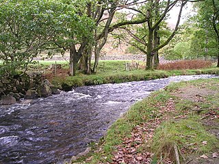
The Whillan Beck is a river in the west of the Lake District National Park in the English county of Cumbria. Administratively, the whole of the course of the Whillan Beck lies in the civil parish of Eskdale and the unitary authority of Cumberland.

References

  1. "The Railway". The Ravenglass & Eskdale Railway Preservation Society. Archived from the original on 30 June 2016. Retrieved 30 June 2016.


Preceding station HR icon.svg   Heritage railways Following station
Fisherground   Ravenglass and Eskdale Railway   Dalegarth for Boot