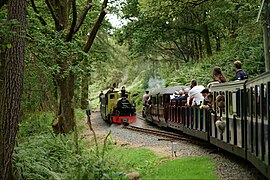
The Ravenglass and Eskdale Railway is a 15 in minimum gauge heritage railway in Cumbria, England. The 7-mile (11.3 km) line runs from Ravenglass to Dalegarth Station near Boot in the valley of Eskdale, in the Lake District. At Ravenglass the line ends at Ravenglass railway station on the Cumbrian Coast Line.

The Talyllyn Railway is a narrow gauge preserved railway in Wales running for 7+1⁄4 miles (12 km) from Tywyn on the Mid-Wales coast to Nant Gwernol near the village of Abergynolwyn. The line was opened in 1865 to carry slate from the quarries at Bryn Eglwys to Tywyn, and was the first narrow gauge railway in Britain authorised by Act of Parliament to carry passengers using steam haulage. Despite severe under-investment, the line remained open, and in 1951 it became the first railway in the world to be preserved as a heritage railway by volunteers.

The Ashover Light Railway was a 1 ft 11+1⁄2 in narrow gauge railway in Derbyshire, England that connected Clay Cross and Ashover. It was built by the Clay Cross Company to transport minerals such as limestone, fluorite, barytes and gritstone to its works at Clay Cross and for transport around the country by the LMS.

Pewsey railway station serves the village of Pewsey in the county of Wiltshire, England. The station is on the Berks and Hants line, 75 miles 26 chains measured from the zero point at London Paddington, and served by intercity trains operated by Great Western Railway between London and the West Country. The average journey time to Paddington from Pewsey is just over an hour. Services between Pewsey and Bedwyn, the next station up the line, are infrequent, most eastbound services next calling at Hungerford, Newbury or Reading instead. This is because Bedwyn was the most westerly point of the Network SouthEast on this line, while Pewsey was an InterCity station.

Ravenglass is a railway station on the Cumbrian Coast Line, which runs between Carlisle and Barrow-in-Furness. The station, situated 29+1⁄4 miles (47 km) north-west of Barrow-in-Furness, serves the village of Ravenglass in Cumbria. It is owned by Network Rail and managed by Northern Trains.

The Duffield Bank Railway was built by Sir Arthur Percival Heywood in the grounds of his house on a hillside overlooking Duffield, Derbyshire in 1874. Although the Ordnance Survey map circa 1880 does not show the railway itself, it does show two tunnels and two signal posts.

The Eaton Hall Railway was an early 15 in gauge minimum gauge estate railway built in 1896 at Eaton Hall in Cheshire. The line, which connected the Grosvenor estate with sidings at Balderton on the GWR Shrewsbury to Chester Line about 3 miles (4.8 km) away, opened in 1896. It was built for the Duke of Westminster by Sir Arthur Percival Heywood, who had pioneered the use of 15 in gauge with his Duffield Bank Railway at his house at Duffield, Derbyshire in 1874.

The South Devon and Tavistock Railway linked Plymouth with Tavistock in Devon; it opened in 1859. It was extended by the Launceston and South Devon Railway to Launceston, in Cornwall in 1865. It was a broad gauge line but from 1876 also carried the standard gauge trains of the London and South Western Railway between Lydford and Plymouth: a third rail was provided, making a mixed gauge. In 1892 the whole line was converted to standard gauge only.

Irton Road railway station is a railway station on the 15 in gauge Ravenglass & Eskdale Railway in the Lake District National Park and the English county of Cumbria. The station is situated on the western edge of the village of Eskdale Green. It is some 4 miles (6.4 km) from Ravenglass and 3 miles (4.8 km) from Dalegarth for Boot, and trains take 20 minutes to reach their destinations in either direction from this station.
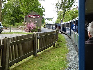
The Green is a railway station on the 15 in gauge Ravenglass & Eskdale Railway in the Lake District National Park and the English county of Cumbria. The station is situated on the southern edge of the village of Eskdale Green, overlooking the Eskdale valley and Muncaster Fell. It was originally known as King of Prussia after the nearby public house, and later as Eskdale Green. The Eskdale Green name has continued in popular use, and was still in official use in 2017 in the railway's "full" timetable of intermediate stopping places.

Murthwaite Halt railway station is a small intermediate railway station on the 15" gauge Ravenglass & Eskdale Railway in Cumbria, England. It is named after the farm that stood in the field opposite the railway. The railway serviced the Murthwaite stone crushing plant, built in the 1920s to crush granite from the quarries further up the railway's valley. This was in operation from the 1920s until 1953, and between 1929 and 1953 there was a standard gauge branch from Ravenglass to the crushing plant, the rails being gauntletted either side of the 15" gauge ones.

Miteside Halt railway station is a railway station on the 15" gauge Ravenglass & Eskdale Railway in Cumbria, England. It is located where public footpath and the railway cross, a short way west of the passing loop. It was first opened in the days of the 3ft gauge railway, to serve the residents of the nearby Miteside House. To provide protection from the elements, a upturned boat hull was provided as a shelter. This tradition of using a boat hull as a shelter continues to this day, the current boat is the third one in the halt's history.

Muncaster Mill railway station is a railway station on the 15 in gauge Ravenglass & Eskdale Railway in Cumbria, England. The station is located 1 mile (1.6 km) from Ravenglass and 6 miles (9.7 km) from Dalegarth, at the point where the A595 coast road crosses the line. It is situated on the bank of the River Mite and adjacent to Muncaster Mill, formerly a watermill but now a private house, from which it takes its name.

Ravenglass Heritage Railway Station is the Western terminus of the Ravenglass and Eskdale Railway. It is situated to the east of Ravenglass main line railway station, which is on the Cumbrian Coast Line. The facilities at the railway station include toilets, under-cover platforms, booking office and café. The railway station complex incorporates 2 locomotive sheds, a carriage shed, a signal box, managerial offices and 2 camping coaches; along with the railway station itself.

Beckfoot railway station is a railway station on the 15" gauge Ravenglass & Eskdale Railway in Cumbria. It is situated within a 1⁄2 mile (0.80 km) walk of the eastern terminus of the line, at Dalegarth station.

Dalegarth railway station is the easterly terminus of the 15" gauge Ravenglass & Eskdale Railway in Cumbria, England. It has a café and shop for passengers, along with a run-round loop, turntable and siding for trains. It is located next to the Whillan Beck, a tributary of the River Esk flowing from the isolated Burnmoor Tarn.

This article gives details of the locomotives used on the Ravenglass and Eskdale Railway, a 15 in narrow gauge preserved railway line running for 7 miles (11 km) from Ravenglass on the Cumbrian coast to Dalegarth near the village of Boot, in Eskdale.

The Helston Railway is a heritage railway in Cornwall which aims to rebuild and preserve as much as possible of the former GWR Helston Railway between Nancegollen and Water-Ma-Trout on the outskirts of Helston. It is operated by the Helston Railway Preservation Company using members of the Helston Railway Preservation Society.
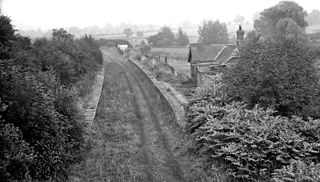
Blakesley was a railway station on the Stratford-upon-Avon and Midland Junction Railway (SMJ) which served the Northamptonshire village of Blakesley between 1873 and 1962. It was linked to nearby Blakesley Hall by a miniature railway which ran from a terminal adjacent to the station.