
Darlington, Western Australia, is a locality in the Shire of Mundaring on the Darling Scarp, bisected by Nyaania Creek and north of the Helena River.

Bellevue is an eastern suburb of Perth, Western Australia in the local government areas of the City of Swan and the Shire of Mundaring. It is at the foot of the slopes of Greenmount, a landmark on the Darling Scarp that is noted in the earliest of travel journals of the early Swan River Colony.

Greenmount is a locality and a geographical feature in the Shire of Mundaring, Western Australia, on the edge of the Darling Scarp. It is a vital point in the transport routes from the Swan Coastal Plain into the hinterland of Western Australia.

The Helena River is a tributary of the Swan River in Western Australia. The river rises in country east of Mount Dale and flows north-west to Mundaring Weir, where it is dammed. It then flows west until it reaches the Darling Scarp.

The Division of Pearce is an Australian electoral division in the state of Western Australia. It was created at the 1989 redistribution and named after George Pearce, the longest serving member of the Australian Senate, serving from 1901 to 1938. For most of its existence, Pearce was a hybrid urban-rural seat that covered Perth's outer northern suburbs before fanning inland from the Indian Ocean to take in portions of the Wheatbelt southeast, east and northeast of the capital. However, as of the 2021 redistribution, Pearce is largely coterminous with the City of Wanneroo in Perth's northern suburbs. It has had four members: Fred Chaney, Judi Moylan, Christian Porter, and Tracey Roberts. The first three were members of the Liberal Party, whereas Roberts, a former mayor of Wanneroo, is a member of the Labor Party.

Glen Forrest is a suburb within the Shire of Mundaring, south of John Forrest National Park, west of Mahogany Creek, east of Darlington, and north of the Helena River. Its northern boundary is determined by the Great Eastern Highway.

Chidlow is a small community in the Shire of Mundaring approximately 45 kilometres east of Perth, Western Australia.
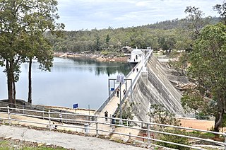
Mundaring Weir is a concrete gravity dam located 39 kilometres (24 mi) from Perth, Western Australia in the Darling Scarp. The dam and reservoir form the boundary between the suburbs of Reservoir and Sawyers Valley. The dam impounds the Helena River.

Swan View is an eastern suburb of Perth, Western Australia. Its local government areas are the City of Swan and the Shire of Mundaring. It is 25 kilometres (16 mi) from Perth in the Perth Hills on the edge of the Darling Scarp, just to the west of the John Forrest National Park, east of Roe Highway and north of the Great Eastern Highway.

Boya is a locality on the Darling Scarp, in the Shire of Mundaring, Western Australia; it is on the south side of Greenmount Hill, and just west of Darlington.
Wooroloo is a town on the outer fringe of the Perth metropolitan region, located off Great Eastern Highway in the eastern part of the Shire of Mundaring. At the 2021 census, Wooroloo had a population of 2,613.

Mahogany Creek is a suburb of Perth, the state capital of Western Australia. It is part of the Shire of Mundaring local government area.
Bailup is a Western Australian locality and rural residential estate located 62 kilometres (39 mi) northeast of the state capital, Perth, along Toodyay Road. The population recorded at the 2021 census was 54. The area is split between the Shire of Toodyay and Shire of Mundaring, the latter of which contains most of the Bailup area.
Stoneville is a suburb east of Perth in the Shire of Mundaring, Western Australia. It is named after Edward Albert Stone, who was Chief Justice of Western Australia when the place was named in 1905. The name was chosen by the local residents, who were developing the district for fruit growing. The town's population is 2,050, with a median age of 36 years and 7.1% of residents aged over 65.

Sawyers Valley is sited on the Great Eastern Highway about 40 kilometres from Perth, Western Australia in the Shire of Mundaring. The community began as a sawmill and railway siding to process timber from the forest surrounding the Helena River to the south. Local employment included forest and Goldfields Water Supply Scheme maintenance, small orchards, and the Midland Railway Workshops. The suburb's name comes from the occupation of many of the first European settlers to the area in the 1860s, who were sawyers working at the local saw-pits. The Sawyers Valley Tavern, which sits on the Highway opposite the Railway Reserve Heritage Trail, was first established in 1882 and the Sawyers Valley railway station was built in 1884.
The Lakes is an outer northeastern locality of Perth, the capital city of Western Australia, located within the Shire of Mundaring. It is located 51 kilometres (32 mi) east of the Perth CBD, at the junction of the Great Eastern Highway and the Great Southern Highway, and is the easternmost suburb within the Metropolitan Region Scheme. At the 2021 census, The Lakes had a population of 20.

Hovea is a suburb in the Shire of Mundaring in Perth, Western Australia.

The Shire of Northam is a local government area in the Wheatbelt region of Western Australia, beyond the northeastern fringe of the Perth metropolitan area centred on the town of Northam itself. The Shire covers an area of 1,431 square kilometres (553 sq mi). In 2007, it merged with the Town of Northam, almost tripling its population in the process from a previous size of 3,794.

The Shire of Mundaring is a local government area in eastern metropolitan Perth, the capital of Western Australia. The Shire covers an area of 645 square kilometres (249 sq mi) and had a population of approximately 38,000 as at the 2016 Census.
The Kep Track is a bicycle, walking and horse track in the Darling Range and further east in Western Australia.
