Darlington, Western Australia

Last updated

Darlington
Perth,  Western Australia
Darlington former railway station patform.jpg
Darlington railway platform
Darlington, Western Australia
Coordinates 31°54′04″S116°04′52″E / 31.901°S 116.081°E / -31.901; 116.081 Coordinates: 31°54′04″S116°04′52″E / 31.901°S 116.081°E / -31.901; 116.081
Population3,656 (2016 census) [1]
 • Density307.2/km2 (796/sq mi)
Postcode(s) 6070
Area11.9 km2 (4.6 sq mi)
Location20 km (12 mi) from Perth
LGA(s) Shire of Mundaring
State electorate(s) Kalamunda
Federal division(s) Hasluck
Suburbs around Darlington:
Greenmount John Forrest National Park Hovea
Boya Darlington Glen Forrest
Helena Valley

Darlington, Western Australia, is a locality in the Shire of Mundaring on the Darling Scarp, bisected by Nyaania Creek and north of the Helena River.

Contents

Location

About one kilometre to the west of Darlington and lower on the Darling Scarp lies the locality of Boya. Between Darlington and Boya there are two abandoned quarries: C. Y. O'Connor's "Fremantle Harbour Works Quarry", [2] now known as "Hudman Road Amphitheatre", and the Mountain Quarry which is also called Boya quarry. [3] They are situated on the southern slope of Greenmount Hill which is defined by the Great Eastern Highway to the north, and the Helena River to the south. The boundary with Glen Forrest to the east has shifted a few times.

Geology

Darlington is located upon the escarpment of the Darling Fault which trends north-south across the south-west of Western Australia, defining what is known as the Perth Hills.

History

Darlington developed as a locality from the establishment of the Darlington Winery in the late nineteenth century. [4] [5] Unlike Glen Forrest and Greenmount, Darlington was unplanned. Darlington Hall was originally built for the winery.

From 1890 to 1954, Darlington was served by the Mundaring Loop on the Eastern Railway, which bisected the town. [6] [7] Darlington was included in "picnic" and "excursion" train itineraries in the 1930s and 1940s. [8] In 1966, the line was officially closed by act of parliament and the tracks removed. The Railway Reserves Heritage Trail, or "bridle trail" as it is known by locals, now occupies the former railway route, and has become a popular walking and bike trail.

Darlington had extensive orchards during the early 20th century. D. H. Lawrence stayed in a local guest house for a short time during his visit to Australia. Guest houses were also used as convalescent homes during the Second World War. By the mid-20th century, many artists had lived in or been associated with the small community. By the late 20th century, the break-up of farms and orchards, with the resulting subdivision of land, had contributed to an increase in the local population.

Parks and reserves

Population

In the 2016 census, there were 3,656 people in Darlington. 65.4% of people were born in Australia. The next most common country of birth was England at 14.0%. 90.3% of people spoke only English at home. The most common responses for religion were No Religion 40.9%, Anglican 19.3% and Catholic 13.9%. [1]

Identity

Very early on, because of its altitude and separation from the Swan Coastal Plain, Darlington became established as a popular picnic area, country drive destination, and a place for holiday homes.

Writers, artists and others seeking to be separate from Perth's extensive suburban sand plain had sought the location for its natural surroundings. The artists gained the most publicity for their residence, while the writers and others tended to keep their privacy.

Some of the community groups are over 40 years old. For example, the Darlington Residents and Ratepayers Association evolved from the earlier Darlington Progress Association, [9] the Darlington Arts Festival as well. The tennis, cricket [10] and other sports clubs have similar heritage.

A newer arrival, the Darlington Club, is less than two years old and as a social club, is involved in sustaining community involvement and use of the Darlington Hall. [11]

It is one of the few hills communities to be served by several primary schoolsthe Darlington Primary School (state school), [12] Tree-Tops Montessori School, and Helena College. [13]

The Darlington Arts Festival, an annual event, has been going for more than 40 years. It includes art exhibitions and other events on the Darlington oval.

The 2006 "Trek the Trail" event was organised on the Railway Reserve Heritage Trail and went from Mundaring to Darlington, and included events on the oval.

The Darlington Review is a monthly publication of some 50 years standing, featuring stories, news, advertisements and other material of local interest. It is one of the few of its kind to serve any hills community for such a long time and is delivered to each address in the locality.

Notable former residents

See also

Bibliography

Related Research Articles

Greenmount National Park Protected area in Western Australia

Greenmount National Park is a national park in the locality of Greenmount, Western Australia, 22 km east of Perth.

John Forrest National Park Protected area in Western Australia

John Forrest National Park is a national park in the Darling Scarp, 24 km (15 mi) east of Perth, Western Australia. Proclaimed as a national park in November 1900, it was the first national park in Western Australia and the second in Australia after Royal National Park.

Darling Scarp Scarp east of Perth, Western Australia

The Darling Scarp, also referred to as the Darling Range or Darling Ranges, is a low escarpment running north–south to the east of the Swan Coastal Plain and Perth, Western Australia. The escarpment extends generally north of Bindoon, to the south of Pemberton. The adjacent Darling Plateau goes easterly to include Mount Bakewell near York and Mount Saddleback near Boddington. It was named after the Governor of New South Wales, Lieutenant-General Ralph Darling.

Mundaring, Western Australia Suburb of Perth, Western Australia

Mundaring is a suburb located 34 km east of Perth, Western Australia on the Great Eastern Highway. The suburb is located within the Shire of Mundaring.

Mount Helena is an urban suburb on the outskirts of Perth, in Western Australia, 35 km from the city, in the Shire of Mundaring. Its population in 2016 was 3,185 people.

Eastern Railway (Western Australia) Railway line in Western Australia

The Eastern Railway is the main railway route between Fremantle and Northam in Western Australia. It opened in stages between 1881 and 1893. The line continues east to Kalgoorlie as the Eastern Goldfields Railway.

Bellevue, Western Australia Suburb of Perth, Western Australia

Bellevue is an eastern suburb of Perth, Western Australia in the local government areas of the City of Swan and the Shire of Mundaring. It is at the foot of the slopes of Greenmount, a landmark on the Darling Scarp that is noted in the earliest of travel journals of the early Swan River Colony.

Greenmount, Western Australia Suburb of Perth, Western Australia

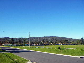
Greenmount is a locality and a geographical feature in the Shire of Mundaring, Western Australia, on the edge of the Darling Scarp. It is a vital point in the transport routes from the Swan Coastal Plain into the hinterland of Western Australia.

Helena River River in Western Australia

The Helena River is a tributary of the Swan River in Western Australia. The river rises in country east of Mount Dale and flows north-west to Mundaring Weir, where it is dammed. It then flows west until it reaches the Darling Scarp.

Railway Reserves Heritage Trail Trail in Shire of Mundaring, Western Australia

The Railway Reserves Heritage Trail – also on some maps as Rail Reserve Heritage Trail or Rail Reserves Historical Trail, and frequently referred to locally as the Bridle Trail or Bridle Track – is within the Shire of Mundaring in Western Australia.

Glen Forrest, Western Australia Suburb of Perth, Western Australia

Glen Forrest is a suburb within the Shire of Mundaring, south of John Forrest National Park, west of Mahogany Creek, east of Darlington, and north of the Helena River. Its northern boundary is determined by the Great Eastern Highway.

The Mundaring Branch Railway is a historical section of the original Eastern Railway main line across the Darling Scarp in the Western Australian Government Railways (WAGR) system.

Mundaring Weir Body of water

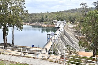
Mundaring Weir is a dam located 39 kilometres (24 mi) from Perth, Western Australia in the Darling Scarp. The dam and reservoir form the boundary between the suburbs of Reservoir and Sawyers Valley. The dam impounds the Helena River.

Swan View, Western Australia Suburb of Perth, Western Australia

Swan View is an eastern suburb of Perth, Western Australia. Its local government areas are the City of Swan and the Shire of Mundaring. It is 25 kilometres (16 mi) from Perth in the Perth Hills on the edge of the Darling Scarp, just to the west of the John Forrest National Park, east of Roe Highway and north of the Great Eastern Highway.

Boya, Western Australia Suburb of Perth, Western Australia

Boya is a locality on the Darling Scarp, in the Shire of Mundaring, Western Australia; it is on the south side of Greenmount Hill, and just west of Darlington.

Darlington Hall Hall in Darlington, Western Australia

Darlington Hall is a heritage listed building in Darlington, Western Australia.

Sawyers Valley, Western Australia Suburb of Perth, Western Australia

Sawyers Valley is sited on the Great Eastern Highway about 40 kilometres from Perth, Western Australia in the Shire of Mundaring. The community began as a sawmill and railway siding to process timber from the forest surrounding the Helena River to the south. Local employment included forest and Goldfields Water Supply Scheme maintenance, small orchards, and the Midland Railway Workshops. The suburb's name comes from the occupation of many of the first European settlers to the area in the 1860s, who were sawyers working at the local saw-pits. The Sawyers Valley Tavern, which sits on the Highway opposite the Railway Reserve Heritage Trail, was first established in 1882 and the Sawyers Valley railway station was built in 1884.

Helena Valley, Western Australia Suburb of Perth, Western Australia

Helena Valley is the name of a river valley and a locality in the foothills of the Darling Scarp in Perth, Western Australia.

Nyaania Creek Seasonal creek in Western Australia

Nyaania Creek is a creek in Western Australia. It is a seasonal tributary that flows into the Helena River with a catchment that moves through a number of hills suburbs just east of the Darling Scarp. Its source is in Mahogany Creek, and it flows through Glen Forrest, Darlington, and Boya before meeting the Helena River at Helena Valley.

References

  1. 1 2 Australian Bureau of Statistics (27 June 2017). "Darlington (State Suburb)". 2016 Census QuickStats. Retrieved 28 December 2018. OOjs UI icon edit-ltr-progressive.svg CC-BY icon.svg Material was copied from this source, which is available under a Creative Commons Attribution 4.0 International License.
  2. "FREMANTLE HARBOUR WORKS". Western Mail . Vol. XVIII, no. 885. Western Australia. 13 December 1902. p. 49. Retrieved 7 November 2016 via National Library of Australia.
  3. "BOYA COMPLAINT AT BLASTING". The West Australian . Vol. 50, no. 15, 004. Western Australia. 24 July 1934. p. 19. Retrieved 7 November 2016 via National Library of Australia.
  4. Darlington Village History from website archived
  5. "THE VINEYARDS OF WESTERN AUSTRALIA". The West Australian . Vol. XXVIII, no. 8, 295. Western Australia. 2 November 1912. p. 12. Retrieved 7 November 2016 via National Library of Australia.
  6. "Mundaring Meeting Protests Against Closure of Loop Railway Line". The Swan Express . Vol. LV, no. 1. Western Australia. 14 January 1954. p. 1. Retrieved 7 November 2016 via National Library of Australia.
  7. "MUNDARING TRANSPORT ENDS SOON". The West Australian . Vol. 70, no. 21, 059. Western Australia. 19 January 1954. p. 7. Retrieved 7 November 2016 via National Library of Australia.
  8. "COUNTRY TOWNS and DISTRICTS THE DARLING RANGES". Western Mail . Vol. XLVII, no. 2, 434. Western Australia. 6 October 1932. p. 8. Retrieved 7 November 2016 via National Library of Australia.
  9. "Darlington". The Swan Express . Vol. XXXI, no. 2. Western Australia. 8 November 1929. p. 6. Retrieved 7 November 2016 via National Library of Australia.
  10. Burns, Cliff; Darlington Social Cricket Club (issuing body.) (2014), Darlington and surrounds : social cricket in Darlington : essentially a history of the Darlington Social Cricket Club (Third ed.), Darlington, WA Darlington Social Cricket Club, ISBN   978-0-9806454-3-9
  11. Not to be confused with the earlier name for the Darlington Golf Club - "DARLINGTON CLUB". The West Australian . Vol. XLIII, no. 7, 749. Western Australia. 2 April 1927. p. 15. Retrieved 7 November 2016 via National Library of Australia.
  12. Wiltshire, Trea; Darlington Primary School (W.A.) (1982), 1912-1982, Darlington Primary School : a short history, Darlington Primary School, ISBN   978-0-9592759-0-2
  13. Helena College (1990), Reflections, Helena College, retrieved 7 November 2016