Belleville, Pennsylvania

Last updated

Belleville
CDP
Belleville PA Community Center.jpg
Community Center
USA Pennsylvania location map.svg
Red pog.svg
Belleville
Location within the U.S. state of Pennsylvania
Coordinates: 40°36′12″N77°43′29″W / 40.60333°N 77.72472°W / 40.60333; -77.72472
Country United States
State Pennsylvania
County Mifflin
Area
[1]
  Total2.00 sq mi (5.17 km2)
  Land2.00 sq mi (5.17 km2)
  Water0.00 sq mi (0.00 km2)
Population
 (2020) [2]
  Total1,947
  Density975.45/sq mi (376.67/km2)
Time zone UTC-5 (Eastern (EST))
  Summer (DST) UTC-4 (EDT)
ZIP codes
17004
Area code 717
GNIS feature ID42-05304

Belleville is a census-designated place (CDP) in the Kishacoquillas Valley of Mifflin County, Pennsylvania, United States. The population was 1,827 at the 2010 census. Much of the population is Amish or Mennonite. [3]

Contents

History

Amish settled in the area by 1791. Mennonites arrived soon after and the two groups dominate the area's population. Though some Amish churches in the area allow members to drive motorized vehicles, most local Amish drive horse-powered buggies. The color of the buggy tops, yellow, white, or black, indicate the owner's church membership. [3]

The auction in Belleville is a popular destination every Wednesday. Locally grown produce, homemade baked goods, and farm-raised animals are available. A flea market is held at the same time. [3]

Children attend schools in the Mifflin County School District.

Belleville is the place where World champion Horseshoe pitcher Darle Esh was born. He was classed in the top 3% in the world.

Geography

1939 aerial view 1939 Belleville, PA (14788334102).jpg
1939 aerial view
Yellow topped buggy of the Byler Amish in Belleville Yellow top buggy Belleville PA.jpg
Yellow topped buggy of the Byler Amish in Belleville
White topped buggy of the Nebraska Amish with a model horse on Main Street Buggy model horse Belleville PA.jpg
White topped buggy of the Nebraska Amish with a model horse on Main Street

Belleville is located at 40°36′12″N77°43′29″W / 40.60333°N 77.72472°W / 40.60333; -77.72472 (40.603376, -77.724822). [4] Pennsylvania Route 655 is known as Main Street within the village, with residences and a few businesses spread out within about two blocks of Main Street.

According to the United States Census Bureau, the CDP has a total area of 2.1 square miles (5.4 km2), all land.

Demographics

Historical population
CensusPop.Note
2020 1,947
U.S. Decennial Census [5] [2]

As of the census [6] of 2000, there were 1,386 people, 572 households, and 407 families residing in the CDP. The population density was 667.4 inhabitants per square mile (257.7/km2). There were 589 housing units at an average density of 283.6 per square mile (109.5/km2). The racial makeup of the CDP was 99.64% White, 0.07% African American, 0.07% Native American, 0.14% Asian, and 0.07% from two or more races. Hispanic or Latino of any race were 0.36% of the population.

There were 572 households, out of which 27.1% had children under the age of 18 living with them, 62.2% were married couples living together, 6.3% had a female householder with no husband present, and 28.7% were non-families. 26.9% of all households were made up of individuals, and 14.0% had someone living alone who was 65 years of age or older. The average household size was 2.42 and the average family size was 2.93.

In the CDP, the population was spread out, with 24.3% under the age of 18, 5.6% from 18 to 24, 24.9% from 25 to 44, 25.0% from 45 to 64, and 20.2% who were 65 years of age or older. The median age was 42 years. For every 100 females, there were 90.1 males. For every 100 females age 18 and over, there were 86.3 males.

The median income for a household in the CDP was $34,352, and the median income for a family was $40,096. Males had a median income of $32,933 versus $21,490 for females. The per capita income for the CDP was $15,202. About 2.0% of families and 6.1% of the population were below the poverty line, including 5.2% of those under age 18 and 9.1% of those age 65 or over.

See also

Related Research Articles

<span class="mw-page-title-main">Paradise, Pennsylvania</span> Census-designated place in Pennsylvania, United States

Paradise is an unincorporated community and census-designated place (CDP) in Lancaster County, Pennsylvania, United States, with a ZIP code of 17562. The population was 1,129 at the 2010 census.

<span class="mw-page-title-main">Mifflin County, Pennsylvania</span> County in Pennsylvania, United States

Mifflin County is a county in the Commonwealth of Pennsylvania. As of the 2020 census, the population was 46,143. Its county seat is Lewistown. The county was created on September 19, 1789, from parts of Cumberland County and Northumberland County. It was named for Thomas Mifflin, the first Governor of Pennsylvania. Mifflin County comprises the Lewistown, PA Micropolitan Statistical Area.

<span class="mw-page-title-main">Holmes County, Ohio</span> County in Ohio, United States

Holmes County is a county in the U.S. state of Ohio. As of the 2020 census, the population was 44,223. Its county seat is Millersburg. The county was formed in 1824 from portions of Coshocton, Tuscarawas and Wayne counties and organized the following year. It was named after Andrew Holmes, an officer killed in the War of 1812.

<span class="mw-page-title-main">Caneyville, Kentucky</span> City in Kentucky, United States

Caneyville is a home rule-class city in Grayson County, Kentucky, in the United States. The population was 608 at the 2010 census. Named for its location on Caney Creek, Caneyville had a post office by 1837 and a town charter by 1840 and was incorporated by the state legislature in 1880.

<span class="mw-page-title-main">Fleetwood, Pennsylvania</span> Borough in Pennsylvania, United States

Fleetwood, also called Schlegelschteddel in Pennsylvania Dutch, is a borough in Berks County, Pennsylvania, United States. The population was 4,085 at the 2010 census. It was home to the Fleetwood Metal Body company, an automobile coachbuilder purchased by Fisher Body and integrated into General Motors in 1931. The name lived on in the Cadillac Fleetwood automobile.

<span class="mw-page-title-main">Homeacre-Lyndora, Pennsylvania</span> Census-designated place in Pennsylvania, United States

Homeacre-Lyndora is a census-designated place (CDP) in Butler County, Pennsylvania, United States. The population was 6,906 at the 2010 census.

<span class="mw-page-title-main">Julian, Pennsylvania</span> Census-designated place in Pennsylvania, United States

Julian is an unincorporated community and census-designated place (CDP) that is located in Centre County, Pennsylvania, United States. It is part of the State College, Pennsylvania Metropolitan Statistical Area. The population was 152 at the 2010 census. Most locals pronounce the name "Joo-lee-ānn".

<span class="mw-page-title-main">Rebersburg, Pennsylvania</span> Census-designated place in Pennsylvania, United States

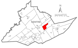
Rebersburg is an unincorporated community and census-designated place (CDP) in Centre County, Pennsylvania, United States. Rebersburg is part of the State College, Pennsylvania Metropolitan Statistical Area. The official town Mayor is Mr. Matthew S. Dunlap(Republican). The mayor was instrumental in securing funds for the purchase of Engine-Rescue 19 as well as funding for the purchase of a new road maintenance truck. Mayor Dunlap also chaired the rural water board which assisted in the township being granted funding for a water filter system at the water reservoir. The population was 494 at the 2010 census and includes many Amish in the area.

<span class="mw-page-title-main">Zion, Pennsylvania</span> Census-designated place in Pennsylvania, United States

Zion is an unincorporated community and census-designated place (CDP) in Centre County, Pennsylvania, United States.

<span class="mw-page-title-main">Brady Township, Clearfield County, Pennsylvania</span> Township in Pennsylvania, United States

Brady Township is a township in Clearfield County, Pennsylvania, United States. The population was 1,942 at the 2020 census.

<span class="mw-page-title-main">Smicksburg, Pennsylvania</span> Borough in Pennsylvania, United States

Smicksburg is a borough in Indiana County, Pennsylvania, United States. The population was 57 at the 2020 census, and it is one of the smallest incorporated boroughs in Pennsylvania. It was founded by the Reverend J. George Schmick.

<span class="mw-page-title-main">Mifflintown, Pennsylvania</span> Borough in Pennsylvania, United States

Mifflintown is a borough in and the county seat of Juniata County, Pennsylvania, United States. The population was 842 at the 2020 census.

<span class="mw-page-title-main">Leacock Township, Lancaster County, Pennsylvania</span> Township in Pennsylvania, United States

Leacock Township is an American township that is located in east central Lancaster County, Pennsylvania. As of the 2020 census, the population of the township was 5,652, an increase over the figure of 5,220 tabulated in 2010.

Leacock-Leola-Bareville is a census-designated place (CDP) in Lancaster County, Pennsylvania, in the United States. As of the 2000 census, the CDP population was 6,625. The area is heavily populated by the Amish and Mennonites. Bareville is often named in lists of "delightfully-named towns" in Pennsylvania Dutchland, along with Intercourse, Blue Ball, Lititz, Mount Joy, Bird-in-Hand and Paradise.

Highland Park is a census-designated place (CDP) in Mifflin County, Pennsylvania, United States. The population was 1,446 at the time of the 2000 census.

<span class="mw-page-title-main">Menno Township, Mifflin County, Pennsylvania</span> Township in Pennsylvania, United States

Menno Township is a township in Mifflin County, Pennsylvania, United States. The population was 1,978 at the time of the 2020 census.

Milroy is a census-designated place (CDP) that is located in the Kishacoquillas Valley of Mifflin County, Pennsylvania, United States. The population was 1,386 at the time of the 2000 census.

<span class="mw-page-title-main">Reedsville, Pennsylvania</span> Census-designated place in Pennsylvania, United States

Reedsville is a census-designated place (CDP) in the Kishacoquillas Valley of Mifflin County, Pennsylvania, United States. The population was 641 at the 2010 census. Reedsville has a high Amish population.

Yeagertown is a census-designated place (CDP) in Mifflin County, Pennsylvania, United States. The population was 1,035 at the 2000 census.

<span class="mw-page-title-main">Harleysville, Pennsylvania</span> Census-designated place in Pennsylvania, United States

Harleysville is a census-designated place (CDP) in Montgomery County, Pennsylvania, United States. It is a suburb of Philadelphia. The population was 9,286 at the 2010 census. It is located mostly within Lower Salford Township and also in Franconia Township. Harleysville was settled by Pennsylvania Dutch in the 18th century and was named after Samuel Harley.

References

  1. "ArcGIS REST Services Directory". United States Census Bureau. Retrieved October 12, 2022.
  2. 1 2 "Census Population API". United States Census Bureau. Retrieved October 12, 2022.
  3. 1 2 3 National Geographic Society, Book Division (1998). "Big Valley Amish". America's Hidden Corners. pp.  77–80. ISBN   0-7922-7210-2.
  4. "US Gazetteer files: 2010, 2000, and 1990". United States Census Bureau. February 12, 2011. Retrieved April 23, 2011.
  5. "Census of Population and Housing". Census.gov. Retrieved June 4, 2016.
  6. "U.S. Census website". United States Census Bureau . Retrieved January 31, 2008.