Highland Park, Pennsylvania

Last updated
Kirklyn
CDP
USA Pennsylvania location map.svg
Red pog.svg
Kirklyn
Location within the U.S. state of Pennsylvania
Coordinates: 40°37′10″N77°33′58″W / 40.61944°N 77.56611°W / 40.61944; -77.56611 Coordinates: 40°37′10″N77°33′58″W / 40.61944°N 77.56611°W / 40.61944; -77.56611
Country United States
State Pennsylvania
County Mifflin
Area
[1]
  Total0.74 sq mi (1.92 km2)
  Land0.74 sq mi (1.92 km2)
  Water0.00 sq mi (0.00 km2)
Population
 (2020) [2]
  Total1,317
  Density1,777.33/sq mi (686.40/km2)
Time zone UTC-5 (Eastern (EST))
  Summer (DST) UTC-4 (EDT)
FIPS code 42-34592

Highland Park is a census-designated place (CDP) in Mifflin County, Pennsylvania, United States. The population was 1,446 at the time of the 2000 census.

Contents

General information

Geography

Highland Park is located at 40°37′10″N77°33′58″W / 40.61944°N 77.56611°W / 40.61944; -77.56611 (40.619420, -77.566009). [3]

According to the United States Census Bureau, the CDP has a total area of 0.7 square miles (1.8 km2), all of it land.

Demographics

Historical population
CensusPop.Note
2020 1,317
U.S. Decennial Census [4]

As of the census [5] of 2000, there were 1,446 people, 594 households, and 374 families residing in the CDP.

The population density was 1,958.7 people per square mile (754.5/km2). There were 624 housing units at an average density of 845.3/sq mi (325.6/km2).

The racial makeup of the CDP was 98.20% White, 0.35% African American, 0.41% Asian, 0.62% from other races, and 0.41% from two or more races. Hispanic or Latino of any race were 1.04% of the population.

There were 594 households, out of which 22.6% had children under the age of eighteen living with them; 53.2% were married couples living together, 7.2% had a female householder with no husband present, and 36.9% were non-families. 33.5% of all households were made up of individuals, and 20.0% had someone living alone who was sity-five years of age or older.

The average household size was 2.23 and the average family size was 2.81.

In the CDP, the population was spread out, with 18.5% under the age of eighteen, 4.6% from eighteen to twenty-four, 21.4% from twenty-five to forty-four, 25.9% from forty-five to sixty-four, and 29.5% who were sixty-five years of age or older. The median age was forty-nine years.

Billy Eckstein's historical marker, Highland Park BillyEcksteinHistoricalMarker.jpg
Billy Eckstein's historical marker, Highland Park

For every one hundred females, there were 78.7 males. For every one hundred females who were aged eighteen or older, there were 73.2 males.

The median income for a household in the CDP was $38,125, and the median income for a family was $46,000. Males had a median income of $33,015 compared with that of $28,819 for females.

The per capita income for the CDP was $19,422.

Roughly 4.7% of families and 6.2% of the population were living below the poverty line, including 9.0% of those who were under the age of eighteen. No one who was aged sixty-five or older was living in poverty.

Notable people

Jazz musician Billy Eckstine was born in Highland; there is a State Historical Marker at the house where he grew up, 5913 Bryant Street, Highland Park. [6]

Related Research Articles

<span class="mw-page-title-main">Chewsville, Maryland</span> CDP in Maryland, United States

Chewsville is a census-designated place (CDP) in Washington County, Maryland, United States. The population was 293 at the 2000 census.

<span class="mw-page-title-main">Mount Aetna, Maryland</span> CDP in Maryland, United States

Mount Aetna is a census-designated place (CDP) in Washington County, Maryland, United States. The population was 838 at the 2000 census.

<span class="mw-page-title-main">Camp Three, Montana</span> CDP in Montana, United States

Camp Three is a census-designated place (CDP) in Musselshell County, Montana, United States. The population was 138 at the 2000 census.

<span class="mw-page-title-main">Billington Heights, New York</span> Census-designated place in New York, United States

Billington Heights is a hamlet and census-designated place (CDP) in the towns of Elma and Aurora in Erie County, New York, United States. The population was 1,685 at the 2010 census. It is part of the Buffalo–Niagara Falls Metropolitan Statistical Area.

<span class="mw-page-title-main">Highland Township, Adams County, Pennsylvania</span> Township in Pennsylvania, United States

Highland Township is a township in Adams County, Pennsylvania, United States, which was created in 1863 from parts of Hamiltonban, Cumberland, and Franklin townships.

<span class="mw-page-title-main">Orrtanna, Pennsylvania</span> Census-designated place in Pennsylvania, United States

Orrtanna is a census-designated place (CDP) in Adams County, Pennsylvania, United States. The population was 183 at the 2020 census.

Weissport East is a census-designated place (CDP) in Franklin Township in Carbon County, Pennsylvania. It is part of Northeastern Pennsylvania.

<span class="mw-page-title-main">Burnside Township, Centre County, Pennsylvania</span> Township in Pennsylvania, United States

Burnside Township is a township in Centre County, Pennsylvania, United States. It is part of the State College, Pennsylvania Metropolitan Statistical Area. It is located approximately at 41°08′03″N77°09′58″W.

<span class="mw-page-title-main">Highland Township, Clarion County, Pennsylvania</span> Township in Pennsylvania, United States

Highland Township is a township which is located in Clarion County, Pennsylvania, United States.

<span class="mw-page-title-main">Grindstone-Rowes Run, Pennsylvania</span> Former CDP in Pennsylvania, United States

Grindstone-Rowes Run was a census-designated place (CDP) in Fayette County, Pennsylvania, United States.

<span class="mw-page-title-main">Mexico, Juniata County, Pennsylvania</span> Census-designated place in Pennsylvania, United States

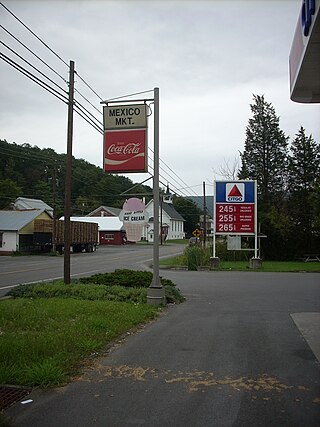
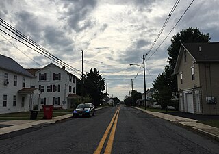
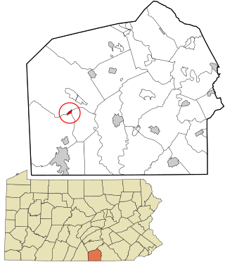
Mexico is an unincorporated community and census-designated place (CDP) in Walker Township, Juniata County, Pennsylvania, United States.

<span class="mw-page-title-main">Menno Township, Mifflin County, Pennsylvania</span> Township in Pennsylvania, United States

Menno Township is a township in Mifflin County, Pennsylvania, United States. The population was 1,978 at the time of the 2020 census.

<span class="mw-page-title-main">Union Township, Mifflin County, Pennsylvania</span> Township in Pennsylvania, United States

Union Township is a township in Mifflin County, Pennsylvania, United States. The population was 3,631 at the time of the 2020 census.

<span class="mw-page-title-main">Wayne Township, Mifflin County, Pennsylvania</span> Township in Pennsylvania, United States

Wayne Township is a township in Mifflin County, Pennsylvania, United States. The population was 2,369 at the time of the 2020 census.

<span class="mw-page-title-main">Gilbertsville, Pennsylvania</span> Census-designated place in Pennsylvania, United States

Gilbertsville is a census-designated place (CDP) in northwest Montgomery County, Pennsylvania, United States. It is located in Douglass Township at the junction of Routes 73 and 100. The population was 4,832 at the 2010 census, and the ZIP code is 19525. The name is also applied to an indeterminate adjacent section of New Hanover Township served by the Gilbertsville Post Office, and in fact the New Hanover Township offices are located in an area considered to be part of Gilbertsville. Boyertown Area School District covers the town of Gilbertsville. Gilbertsville is considered a exurb to the northwest of Philadelphia.

<span class="mw-page-title-main">Liberty, Tioga County, Pennsylvania</span> Borough in Pennsylvania, United States

Liberty is a small borough in Tioga County, Pennsylvania, United States. The population was 232 at the time of the 2020 census.

<span class="mw-page-title-main">Westfield, Pennsylvania</span> Borough in Pennsylvania, United States

Westfield is a borough in Tioga County, Pennsylvania, United States. The population was 1,113 at the time of the 2020 census.

Grapeville is a census-designated place (CDP) in Hempfield Township, Westmoreland County, Pennsylvania, United States. The population was 676 at the time of the 2000 census.

<span class="mw-page-title-main">Herminie, Pennsylvania</span>

Herminie is a census-designated place (CDP) in Sewickley Township, Westmoreland County, Pennsylvania, United States. The population was 856 at the 2000 census.

<span class="mw-page-title-main">North Belle Vernon, Pennsylvania</span> Borough in Pennsylvania, United States

North Belle Vernon is a borough in Westmoreland County, Pennsylvania, United States. The population was 1,971 at the time of the 2010 census.

References

  1. "ArcGIS REST Services Directory". United States Census Bureau. Retrieved October 12, 2022.
  2. "Census Population API". United States Census Bureau. Retrieved Oct 12, 2022.
  3. "US Gazetteer files: 2010, 2000, and 1990". United States Census Bureau. 2011-02-12. Retrieved 2011-04-23.
  4. "Census of Population and Housing". Census.gov. Retrieved June 4, 2016.
  5. "U.S. Census website". United States Census Bureau . Retrieved 2008-01-31.
  6. "Billy Eckstine - Pennsylvania Historical Markers on". Waymarking.com. 2006-10-29. Retrieved 2012-03-26.