Highland Park (Pittsburgh neighborhood)

Last updated

Highland Park
935 North Highland Avenue, Highland Park, 2022-05-09, 03.jpg
Pgh locator highland park.svg
Coordinates: 40°28′41″N79°54′58″W / 40.478°N 79.916°W / 40.478; -79.916
Country United States
State Pennsylvania
County Allegheny County
City Pittsburgh
Area
[1]
  Total1.163 sq mi (3.01 km2)
Population
 (2010) [1]
  Total6,395
  Density5,500/sq mi (2,100/km2)

Highland Park is a neighborhood in the northeastern part of Pittsburgh, Pennsylvania. Highland Park, the neighborhood, fully encompasses the park with the same name.

Contents

The neighborhood has 6,395 residents according to the 2010 United States Census. It occupies 748 acres (3.03 km2) built around the 380-acre (1.5 km2) park (also called Highland Park), and is bordered by the neighborhoods of East Liberty and Larimer to the south, Morningside to the west, Lincoln-Lemington-Belmar to the east, and the Allegheny River to the north.

The neighborhood is set apart from surrounding areas by Heth's Run, which separates Highland Park from Morningside to the west, and by Negley Run, which separates it from Lincoln-Lemington-Belmar to the east and Larimer to the south. The only direct land routes to Highland Park are from East Liberty, via Negley Avenue, Highland Avenue, and several other streets.

The Neighborhood

The first permanent European settler in Highland Park was Alexander Negley, a Swiss settler. In 1778, Negley purchased a 278-acre farm along the Allegheny River that he called “Fertile Bottom” and which extended over much of what is now Highland Park north of Bryant Street. His son Jacob married Barbara Winebiddle, the daughter of other local landowners, in 1795, and in 1799 purchased the 443-acre farm (called “Heth’s Delight”) that adjoined his father's farm to the south and west. Jacob and Barbara Negley built a brick house at what is now the corner of Stanton and Negley Avenues in 1808, which became the seat of a substantial land holding when the two farms were combined upon the death of Alexander Negley in 1809.

Jacob Negley was one of the most prominent citizens in the early nineteenth century of the East Liberty Valley, the ancient river bottom that lies north of Squirrel Hill in the eastern section of Pittsburgh and provides relief from the generally hilly topography of the city. The earliest highway from the east, the Greensburg & Pittsburgh Turnpike (now Penn Avenue), which followed the line (the Forbes Road) that the British cut during the French and Indian War, ran east–west through the East Liberty Valley. Jacob Negley won the contract to pave a five-mile section of the turnpike between 1813 and 1819. He played a substantial role in the founding of a village in East Liberty, building a steam-powered grist mill on the turnpike in 1816, establishing a bank, and helping to found the East Liberty Presbyterian Church Church in 1819. His daughter Sara Jane married the lawyer Thomas Mellon, patriarch of the banking family, in 1843.

Upon the death of Jacob Negley in 1827, his widow Barbara built a new farmhouse for herself in 1829, which still stands and which gives its name to the "Farmhouse Park" playground within Highland Park. She also resolved certain debts that she and Jacob had incurred during the Panic of 1819 by selling some parcels of her land. In 1837, Barbara Winebiddle Negley divided the remainder of the estate among her children. This started the process of subdivision of land in East Liberty and Highland Park that led to the development of those neighborhoods in the later nineteenth century. With the subdivision of the estate, the County Surveyor, Robert Hilands, also laid out the first streets in the Highland Park area. He formally established Negley Avenue along the line of the country lane that connected Penn Avenue with the Negley homestead, laid out Hiland Avenue (named after himself until changed to “Highland” by the City in 1890) as the principal street running north out of the center of the village of East Liberty, and converted the Negleys’ principal east–west “Country Lane” into what is now called Stanton Avenue.

In the first half of the nineteenth century, most of the development in the East End of Pittsburgh occurred in the East Liberty section. This growth was spurred on by the construction of the Pennsylvania Railroad's main line to Pittsburgh through the East Liberty Valley in 1852. By 1868, there was a population of about 5000 in the general vicinity of East Liberty. In that year, the municipalities east of Pittsburgh (the townships of Pitt, Peebles, Liberty, Collins and Oakland, and the borough of Lawrenceville) were annexed by the City of Pittsburgh as part of a campaign of expansion that tripled the size of the city and extended its boundaries south of the Monongahela River. Further transportation improvements followed the incorporation of East Liberty into the city. In 1870, the City Councils passed the Penn Avenue Act, which provided a mechanism for the paving of local streets, and in 1872 horse-drawn streetcar service was extended out of Pittsburgh to East Liberty. In addition, the city Water Commission purchased land and began construction in 1872 of a reservoir on the top of the hill at the head of Hiland Avenue that opened in 1879. The land purchases for the reservoir later provided the germ of the Highland Park landscape park that was founded in 1889.

The Highland Park neighborhood was developed as a streetcar suburb: residents walked or used streetcars to reach East Liberty, where they worked, shopped, or took trains to other portions of the City of Pittsburgh. As such, the neighborhood was initially almost wholly residential, with homes that are in many cases quite substantial. These homes are spaced further apart than the rowhouses of fully urban neighborhoods such as Bloomfield and Lawrenceville, but they are much closer together than is typical in a post-1940s automobile suburb. The Highland Park neighborhood's appeal derived (and still derives) in large part from its setting between the large public park to the north and the East Liberty business district to the south. That appeal declined to some extent from 1970–2000, when East Liberty went through an extended period of decline, but East Liberty's renaissance as a commercial district after 2000 has caused the Highland Park neighborhood to become more appealing as well.

Due in part to the aforementioned decline of East Liberty, the Highland Park neighborhood developed a very small business district of its own on Bryant Street, which presently includes a number of restaurants, a neighborhood grocer, a bakery, a coffee shop, an automobile repair facility, and several other small businesses that are interspersed among private residences on Bryant Street. While no streetcars run through the present-day Highland Park neighborhood, it is served by several bus routes which run south to East Liberty and then beyond, eventually to downtown Pittsburgh.

Historic District

On August 30, 2007, the Highland Park Residential Historic District was officially listed on the National Register of Historic Places. [2] The historic district encompasses the entire neighborhood of Highland Park: its western border consists of Chislett Street (from Stanton Avenue on the south to Hampton Street on the north) and Heth's Run (or more specifically, King Avenue and Cordova Street, which are just to the east of Heth's Run). Its southern and eastern border consists of Stanton Avenue, and its northern border is the Allegheny River. [3] Academy Award-winning actor, Gene Kelly, and acclaimed jazz singer, Billy Eckstine, were both born and raised here.

City Steps

The Highland Park neighborhood has 3 distinct flights of city steps - all of which are open and in a safe condition. In Highland Park, the Steps of Pittsburgh quickly connect pedestrians to public transportation, Highland Park, and smaller community playgrounds. [4]

See also

Related Research Articles

<span class="mw-page-title-main">Aspinwall, Pennsylvania</span> Borough in Pennsylvania, United States

Aspinwall is a borough on the Allegheny River in Allegheny County, Pennsylvania. It is part of the Greater Pittsburgh metropolitan area. In 1900, 1,231 people lived in Aspinwall, and that number rose to 2,592 in 1910, and 3,170 by 1920. The population was 2,916 at the 2020 census.

<span class="mw-page-title-main">Oakland (Pittsburgh)</span> Place in Pennsylvania, United States

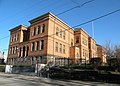
Oakland is the academic and healthcare center of Pittsburgh and one of the city's major cultural centers. The neighborhood is home to three universities, museums, and hospitals, as well as an abundance of shopping, restaurants, and recreational activities. Oakland is home to the Schenley Farms National Historic District which encompasses two city designated historic districts: the mostly residential Schenley Farms Historic District and the predominantly institutional Oakland Civic Center Historic District. It is also home to the locally designated Oakland Square Historic District. The Pittsburgh Bureau of Fire has Fire Station No. 14 on McKee Place and Fire Station No. 10 on Allequippa Street in Oakland.

<span class="mw-page-title-main">Downtown Pittsburgh</span> Neighborhood of Pittsburgh in Allegheny County, Pennsylvania, United States

Downtown Pittsburgh, colloquially referred to as the Golden Triangle, and officially the Central Business District, is the urban downtown center of Pittsburgh. It is located at the confluence of the Allegheny River and the Monongahela River whose joining forms the Ohio River. The triangle is bounded by the two rivers.

<span class="mw-page-title-main">Bloomfield (Pittsburgh)</span> Neighborhood of Pittsburgh in Allegheny County, Pennsylvania, United States

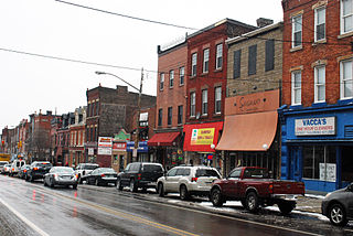
Bloomfield is a neighborhood in Pittsburgh, Pennsylvania. It is located three miles from the downtown area. Bloomfield is sometimes referred to as Pittsburgh's Little Italy because it was settled by Italians from the Abruzzi region and has been a center of Italian–American population. Pittsburgh architectural historian, Franklin Toker, has said that Bloomfield "is a feast, as rich to the eyes as the homemade tortellini and cannoli in its shop windows are to the stomach." Recently, the neighborhood has attracted young adults and college students as a "hip" neighborhood.

<span class="mw-page-title-main">Friendship (Pittsburgh)</span> Neighborhood of Pittsburgh in Allegheny County, Pennsylvania, United States

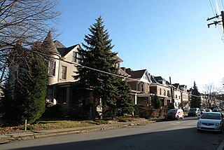
Friendship is a neighborhood of large Victorian houses in the East End of the City of Pittsburgh, Pennsylvania, United States, about four miles (6 km) east of Pittsburgh's Golden Triangle. Friendship is bordered on the north by Garfield, on the east by East Liberty, and on the south by Shadyside, and on the west by Bloomfield. It is divided into 3 Pittsburgh City Council districts.

<span class="mw-page-title-main">Lincoln–Lemington–Belmar (Pittsburgh)</span> Neighborhood of Pittsburgh in Allegheny County, Pennsylvania, United States

Lincoln–Lemington–Belmar is a neighborhood in Pittsburgh, Pennsylvania. It is located in the northeastern section of the city and spans the Allegheny River. Lincoln–Lemington–Belmar houses PBF 15 Engine, and is covered by PBP Zone 5 and the Bureau of EMS Medic 1.

<span class="mw-page-title-main">East Liberty (Pittsburgh)</span> Neighborhood of Pittsburgh in Allegheny County, Pennsylvania, United States

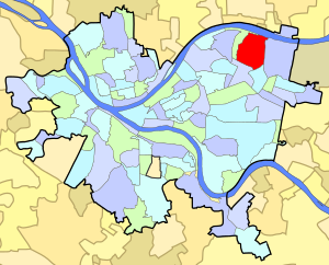
East Liberty is a neighborhood in Pittsburgh, Pennsylvania's East End. It is bordered by Highland Park, Morningside, Stanton Heights, Garfield, Friendship, Shadyside and Larimer, and is represented on Pittsburgh City Council by Councilwoman Deborah Gross and Rev. Ricky Burgess. One of the most notable features in the East Liberty skyline is the East Liberty Presbyterian Church, which is an area landmark.

<span class="mw-page-title-main">Garfield (Pittsburgh)</span> Place in Pennsylvania, United States

Garfield is a neighborhood in the East End of the City of Pittsburgh, Pennsylvania, United States. Garfield is bordered on the South by Bloomfield and Friendship, on the West by the Allegheny Cemetery, on the North by Stanton Heights, and on the East by East Liberty. Like many parts of Pittsburgh, Garfield is a fairly steep neighborhood, with north-south residential streets running at about a 20% incline from Penn Avenue at the bottom to Mossfield Street at the top. Garfield is divided into “the valley” and “the hilltop.”

<span class="mw-page-title-main">Larimer (Pittsburgh)</span> Neighborhood of Pittsburgh in Allegheny County, Pennsylvania, United States

Larimer is a neighborhood in the East End of the City of Pittsburgh, Pennsylvania in the United States. The neighborhood takes its name from William Larimer, who grew up in nearby Westmoreland County and, after making a fortune in the railroad industry, built a manor house overlooking East Liberty along a path that came to be called "Larimer Lane" and later Larimer Avenue.

<span class="mw-page-title-main">Allentown, Allegheny County, Pennsylvania</span> Neighborhood in Allegheny County, Pennsylvania, United States

Allentown is a neighborhood located in southern portion of the city of Pittsburgh, Allegheny County, Pennsylvania. The ZIP code used by residents is 15210, and has representation on the Pittsburgh City Council by the council member for District 3.

<span class="mw-page-title-main">East Allegheny (Pittsburgh)</span> Neighborhood of Pittsburgh in Allegheny County, Pennsylvania, United States

East Allegheny, also known as Deutschtown, is a neighborhood on Pittsburgh's North Side. It has a ZIP Code of 15212, and has representation on Pittsburgh City Council by the council member for District 1. The Pittsburgh Bureau of Fire houses 32 Engine and 32 Truck in Deutschtown.

<span class="mw-page-title-main">Lawrenceville (Pittsburgh)</span> Place in Pennsylvania, United States

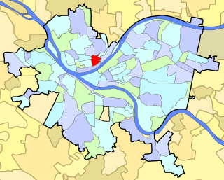
Lawrenceville is one of the largest neighborhood areas in Pittsburgh in the U.S. state of Pennsylvania. It is located northeast of downtown, and like many of the city's riverfront neighborhoods, it has an industrial past. The city considers Lawrenceville three neighborhoods, Upper Lawrenceville, Central Lawrenceville, and Lower Lawrenceville, but these distinctions have little practical effect. Accordingly, Lawrenceville is almost universally treated as being a single large neighborhood.

<span class="mw-page-title-main">Marshall-Shadeland, Pittsburgh</span> Neighborhood of Pittsburgh in Allegheny County, Pennsylvania, United States

Marshall-Shadeland is a neighborhood on Pittsburgh, Pennsylvania's North Side. It has a zip codes of both 15212 and 15214, and has representation on Pittsburgh City Council by the council member for District 1.

<span class="mw-page-title-main">Morningside (Pittsburgh)</span> Neighborhood of Pittsburgh in Allegheny County, Pennsylvania, United States

Morningside is a neighborhood un Pittsburgh, Pennsylvania's East End. It has two Zip Codes, 15201 and 15206.

<span class="mw-page-title-main">Shadyside (Pittsburgh)</span> Neighborhood of Pittsburgh in Allegheny County, Pennsylvania, United States

Shadyside is a neighborhood in the East End of Pittsburgh, Pennsylvania, United States. It has three zip codes and representation on Pittsburgh City Council by the council member for District 8. Shadyside is drawn from the name of a 19th-century Pennsylvania Railroad station in the area, which was named for its shady lanes.

<span class="mw-page-title-main">Stanton Heights (Pittsburgh)</span> Neighborhood of Pittsburgh in Allegheny County, Pennsylvania, United States

Stanton Heights is a neighborhood in Pittsburgh, Pennsylvania's East End. It has zip codes of both 15201 and 15206, and has representation on Pittsburgh City Council by the council member for District 7. Stanton Heights is the home of PBF 7 Engine and the city's Arson Investigation Units, and is covered by PBP Zone 5 and the Bureau of EMS Medic 6.

<span class="mw-page-title-main">West End (Pittsburgh)</span> Neighborhood of Pittsburgh in Allegheny County, Pennsylvania, United States

West End Village is a neighborhood in Pittsburgh, Pennsylvania's west city area. It has a zip code of 15220, and has representation on Pittsburgh City Council by the council member for District 2.

<span class="mw-page-title-main">Pennsylvania Route 130</span> State highway in Pennsylvania, US

Pennsylvania Route 130 (PA 130) is a 49-mile-long (79 km) state highway located in Allegheny and Westmoreland counties in Pennsylvania. The western terminus is at PA 8 in Pittsburgh, and the eastern terminus is at PA 381 near Kregar.

<span class="mw-page-title-main">Highland Park (Pittsburgh park)</span>

Highland Park is a large municipal park in the northeastern part of Pittsburgh, Pennsylvania. It is located in Pittsburgh's Highland Park neighborhood. The park extends along the northern and eastern borders of the neighborhood, following the Allegheny River and Negley Run.

References

  1. 1 2 "PGHSNAP 2010 Raw Census Data by Neighborhood". Pittsburgh Department of City Planning. 2012. Retrieved June 24, 2013.
  2. "National Register of Historic Places Listings". September 7, 2007. Retrieved September 7, 2007.
  3. "Street Listing for Highland Park Residential Historic District" (PDF). February 15, 2002. Retrieved April 28, 2016.
  4. Regan, Bob (2015). Pittsburgh Steps, The Story of the City's Public Stairways. Globe Pequot. ISBN   978-1-4930-1384-5.

Further reading