
Dormont is a borough in Allegheny County, Pennsylvania, United States and is part of the Pittsburgh Metro Area. The population was 8,593 at the 2010 census. Dormont is a home to a diverse population including young professionals, working families, and retirees. Dormont's economic stability can be attributed to this diversity along with its close proximity to jobs in Downtown Pittsburgh, access to The "T", diverse housing stock, and historically low crime rates. Dormont is mixed use and urban and features a pedestrian friendly business district, with bars, coffee shops, restaurants, and retail stores. It is famous for one of the largest municipal pools in Pennsylvania, the historic Dormont Pool. Loosely translated, Dormont means "Mountain of Gold" in French.

McKees Rocks, also known as "The Rocks", is a borough in Allegheny County, in western Pennsylvania, along the south bank of the Ohio River. The borough population was 6,104 at the 2010 census.

Downtown Pittsburgh, colloquially referred to as the Golden Triangle, and officially the Central Business District, is the urban downtown center of Pittsburgh. It is located at the confluence of the Allegheny River and the Monongahela River whose joining forms the Ohio River. The "triangle" is bounded by the two rivers. The area features offices for major corporations such as PNC Bank, U.S. Steel, PPG, Bank of New York Mellon, Heinz, Federated Investors and Alcoa. It is where the fortunes of such industrial barons as Andrew Carnegie, Henry Clay Frick, Henry J. Heinz, Andrew Mellon and George Westinghouse were made. It contains the site where the French fort, Fort Duquesne, once stood.

The Carnegie Library of Pittsburgh is the public library system in Pittsburgh, Pennsylvania. Its main branch is located in the Oakland neighborhood of Pittsburgh, and it has 19 branch locations throughout the city. Like hundreds of other Carnegie libraries, the construction of the main library, which opened in 1895, and several neighborhood branches, was funded by industrialist Andrew Carnegie. The Pittsburgh area holds the distinction of housing the first branches in the United States.
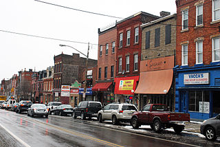
Bloomfield is a neighborhood in Pittsburgh, Pennsylvania. It is located three miles from the downtown area. Bloomfield is sometimes referred to as Pittsburgh's Little Italy because it was settled by Italians from the Abruzzi region and has been a center of Italian–American population. Pittsburgh architectural historian, Franklin Toker, has said that Bloomfield "is a feast, as rich to the eyes as the homemade tortellini and cannoli in its shop windows are to the stomach." Recently, neighborhood has as attracted young adults and college students as a "hip" neighborhood.
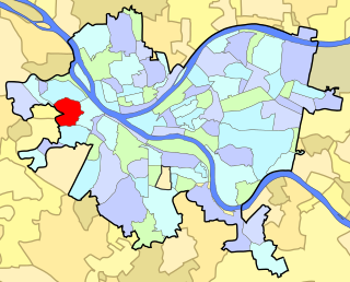
Crafton Heights is a neighborhood in Pittsburgh, Pennsylvania. Its name is derived from the neighboring borough, Crafton Borough, and the majority of today's community was annexed to the City of Pittsburgh in 1921. Crafton Heights is located west of downtown Pittsburgh, and is surrounded by Elliot, Sheraden, and Westwood.
Highland Park is a neighborhood in the northeastern part of Pittsburgh, Pennsylvania. Highland Park, the neighborhood, fully encompasses the park with the same name.

Brookline is a neighborhood in Pittsburgh, Pennsylvania in the United States.

Larimer is a neighborhood in the East End of the City of Pittsburgh, Pennsylvania in the United States. The neighborhood takes its name from William Larimer, who grew up in nearby Westmoreland County and, after making a fortune in the railroad industry, built a manor house overlooking East Liberty along a path that came to be called "Larimer Lane" and later Larimer Avenue.

Knoxville is a neighborhood in southern Pittsburgh, Pennsylvania. It is part of zip code 15210, and has representation on Pittsburgh City Council by the council member for District 3.
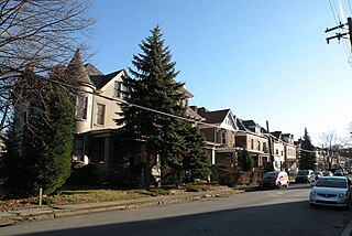
Lawrenceville is one of the largest neighborhood areas in Pittsburgh in the U.S. state of Pennsylvania. It is located northeast of downtown, and like many of the city's riverfront neighborhoods, it has an industrial past. The city considers Lawrenceville three neighborhoods, Upper Lawrenceville, Central Lawrenceville, and Lower Lawrenceville, but these distinctions have little practical effect. Accordingly, Lawrenceville is almost universally treated as being a single large neighborhood.
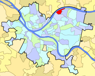
Morningside is a neighborhood on Pittsburgh, Pennsylvania's East End. It has two zip codes, 15201 and 15206, and has a representation on Pittsburgh City Council by Deb Gross for District 7.

Community boards of Manhattan are New York City community boards in the borough of Manhattan, which are the appointed advisory groups of the community districts that advise on land use and zoning, participate in the city budget process, and address service delivery in their district.

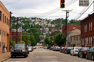
The South Hills is the southern suburbs of Pittsburgh, Pennsylvania, and the neighborhoods in the City of Pittsburgh south of the South Side Slopes. The Pittsburgh neighborhoods include Knoxville, Mt. Oliver, Mt. Washington, Beltzhoover, Allentown, Banksville, Beechview, Brookline, Carrick, and Overbrook. Two suburban municipalities that are included in the South Hills outside of Pittsburgh are Bethel Park and Mt. Lebanon, as well as the boroughs of Castle Shannon, Dormont, and Green Tree. The South Hills also includes the townships of Baldwin, Collier, Peters, Scott, South Park, and Upper St. Clair, plus the boroughs of Baldwin, Brentwood, Bridgeville, Mt. Oliver, Heidelberg, Whitehall, Pleasant Hills, Jefferson Hills, and West Mifflin. Much of the South Hills was originally a land grant to John Ormsby.
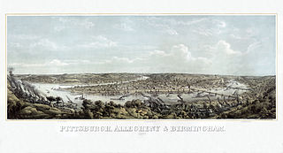
In 1763, King George III provided John Ormsby approximately 2,400 acres (9.7 km2) along the south bank of the Monongahela River as payment for his services during the French and Indian War. The land was then divided into four boroughs: South Pittsburgh, Birmingham, East Birmingham, and Ormsby. The four boroughs were annexed into the City of Pittsburgh in 1872. These areas, collectively, provided for the foundation of the South Side as it is known today.
South Side Slopes is a neighborhood in Pittsburgh, Pennsylvania's South Side area. The neighborhood comprises the hills from the South Side Flats neighborhood along the Monongahela River from the Liberty Bridge (west) to beyond Josephine Street (east).

Peebles Township was a township in Allegheny County, Pennsylvania. Created out of Pitt Township in 1833, it originally included most of what is now the eastern part of the city of Pittsburgh from the Monongahela River in the south to the Allegheny River in the north. Portions of Peebles broke away to form the borough of Lawrenceville (1834) and the townships of Collins (1850) and Liberty (1864). Those municipalities and the remainder of Peebles Township were incorporated into Pittsburgh in 1868.
Pitt Township was one of the original townships created with the formation of Allegheny County, Pennsylvania in 1788. It repeatedly diminished in size until dissolving into the city of Pittsburgh in 1868.


