Lawrenceville (Pittsburgh)

Last updated

Lawrenceville
Pgh locator lawrenceville.svg
Location of Lawrenceville within the city of Pittsburgh
Country United States
State Pennsylvania
County Allegheny County
City Pittsburgh
Founded1814
Incorporated (borough)February 18, 1834
Annexed (by Pittsburgh)June 30, 1868
Founded by William B. Foster
Named for James Lawrence
Upper Lawrenceville
Pgh locator upper lawrenceville.svg
Area
[1]
  Total1.05 km2 (0.405 sq mi)
Population
 (2010) [1]
  Total2,669
  Density2,500/km2 (6,600/sq mi)
Central Lawrenceville
Lawrenceville.jpg
Row houses are common throughout Lawrenceville.
Pgh locator central lawrenceville.svg
Area
[1]
  Total2.49 km2 (0.963 sq mi)
Population
 (2010) [1]
  Total4,482
  Density1,800/km2 (4,700/sq mi)
Lower Lawrenceville
Lower Lawrenceville Pittsburgh.JPG
Shops and professional offices along Butler Street.
Pgh locator lower lawrenceville.svg
Area
[1]
  Total1.1 km2 (0.43 sq mi)
Population
 (2010) [1]
  Total2,341
  Density2,100/km2 (5,400/sq mi)

Lawrenceville is one of the largest neighborhood areas in Pittsburgh in the U.S. state of Pennsylvania. It is located northeast of downtown, and like many of the city's riverfront neighborhoods, it has an industrial past. The city officially divides Lawrenceville into three neighborhoods, Upper Lawrenceville, Central Lawrenceville, and Lower Lawrenceville, but these distinctions have little practical effect. Accordingly, Lawrenceville is almost universally treated as a single large neighborhood. [2]

Contents

In 2019, the Lawrenceville Historic District, which encompasses the majority of the neighborhood, was added to the National Register of Historic Places. [3]

History

Lawrenceville was founded in 1814 by William B. Foster, father of composer Stephen Foster, who was born there in 1826. It is named for Captain James Lawrence, hero of the War of 1812, famous for his dying words, "Don't Give Up The Ship!" [4] Lawrenceville was selected as home to the Allegheny Arsenal, due to "The area's accessibility to river transportation and its proximity to what was then the nation's only iron producing district". Incorporated as a borough on February 18, 1834, Lawrenceville was annexed to the city of Pittsburgh in 1868. [5] One of the original buildings, a log home built in the 1820s, survived until July 2011 at 184 38th Street. [6]

As seen on older maps, two sizable islands once sat opposite Lawrenceville in the Allegheny river: Herrs Island (now known as Washington's Landing), which stretched from roughly 28th street to 37th street, and McCullough's Island (sometimes labeled Wainwright's Island or "Good Liquor" Island), which stretched from roughly 35th street to 40th street. [7] Washington's Landing is named after an event in 1753 in which George Washington was thrown from his raft while crossing the Allegheny River and scrambled to safety on a nearby island. However, Washington did not actually land on Washington's Landing—he landed on McCullough's Island. [8] Although Washington's Landing still exists, McCullough's Island, which sat much closer to the mainland, does not. The channel between McCullough's Island and Lawrenceville was filled in between 1872 and 1882. [9] [10] [11]

Present

Lawrenceville's primary zip code is 15201, though a small section shares 15224 with Bloomfield and Garfield. The neighborhood is home to landmarks such as Allegheny Cemetery, Arsenal Middle School, Arsenal Park, and Doughboy Square. Lawrenceville maintains much of its industrial-era aesthetic, with narrow row houses and old warehouses lining streets and alleyways.

The UPMC Children's Hospital of Pittsburgh opened a new facility in Lawrenceville on May 2, 2009, moving all patients from Oakland. [12] This addition has helped spawn Lawrenceville's transformation, bringing new job and business opportunities to the area. The New York Times has since called the neighborhood a "go-to destination." [13]

Lawrenceville's Butler Street is its main artery, housing a number of restaurants, bars, boutiques, furniture stores, and coffee shops. [14] Arsenal Lanes, [15] a longstanding bowling alley with a full-stocked bar. The Row House Cinema [16] opened in 2014, showing popular classics.

Lawrenceville hosts Pittsburgh's annual Art All Night, an event for amateur artists to showcase their work in a large warehouse, open for free and to the public. In April 2016, the 19th Art All Night event was held in a new location at the Arsenal Terminal Building at 39th and Butler Streets. [17]

Lawrenceville has experienced a real estate boom in recent years. In 2007, price appreciation was the second highest in the city, after the South Side, according to Carnegie Mellon University. [18] In 2015, the Pittsburgh Post-Gazette [19] reported an increasingly high volume of developers looking to Lawrenceville to renovate properties for resale, also known as "flipping" houses, although such opportunities have become less lucrative as prices rise. Many homes now sell upwards of $200,000. As a result of this growth, Lawrenceville is typical of Pittsburgh's gentrification: once a working-class district, the neighborhood now caters to higher-earning buyers. Increases in construction and commercial enterprise have also led to a shortage of street parking, [20] as hundreds of drivers try to squeeze their cars onto too-narrow streets.

Arsenal Park remains a popular recreation spot, hosting July 4 events each year, and the VFW center and Teamster Temple are active.

Lawrenceville was used as a location for some scenes of the film Love & Other Drugs (2010), starring Jake Gyllenhaal and Anne Hathaway. [21]

Surrounding and adjacent neighborhoods

Lower Lawrenceville has four land borders with the Pittsburgh neighborhoods of Central Lawrenceville to the northeast, Bloomfield to the east, Polish Hill to the south, and the Strip District to the southwest. Across the Allegheny River, the Lower neighborhood runs adjacent with the Pittsburgh neighborhood of Troy Hill and Millvale with a direct link to the latter via 40th Street Bridge.

Central Lawrenceville has five land borders with the Pittsburgh neighborhoods of Upper Lawrenceville to the north, Stanton Heights to the east and northeast, Garfield to the southeast, Bloomfield to the south and Lower Lawrenceville to the southwest. Its adjacent neighborhoods across the Allegheny River include Millvale and Shaler Township.

Upper Lawrenceville has three land borders with the Pittsburgh neighborhoods of Morningside to the east, Stanton Heights to the southeast, and Central Lawrenceville to the south and southwest. The Upper section runs adjacent across the Allegheny River with Shaler Township.

Notable residents

See also

Related Research Articles

<span class="mw-page-title-main">Pittsburgh</span> Second-most populous city in Pennsylvania, United States

Pittsburgh is a city in the Commonwealth of Pennsylvania and the county seat of Allegheny County. It is the second-most populous city in Pennsylvania after Philadelphia and the 68th-most populous city in the U.S. with a population of 302,971 as of the 2020 census. The city anchors the Pittsburgh metropolitan area of Western Pennsylvania. Its population of 2.457 million is the largest in both the Ohio Valley and Appalachia, the second-largest in Pennsylvania, the 7th-largest in the Mid-Atlantic region and the 26th-largest in the U.S. Pittsburgh is the principal city of the greater Pittsburgh–Weirton–Steubenville combined statistical area which includes parts of Ohio and West Virginia.

<span class="mw-page-title-main">Millvale, Pennsylvania</span> A borough in Allegheny County, Pennsylvania

Millvale is a borough in Allegheny County, Pennsylvania, United States, along the Allegheny River, opposite Pittsburgh. The borough is located off Pennsylvania Route 28. The population was 3,376 at the 2020 census.

<span class="mw-page-title-main">Oakland (Pittsburgh)</span> Place in Pennsylvania, United States

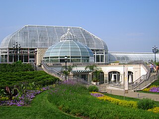
Oakland is the academic and healthcare center of Pittsburgh and one of the city's major cultural centers. Home to three universities, museums, hospitals, shopping venues, restaurants, and recreational activities, this section of the city also includes two city-designated historic districts: the mostly residential Schenley Farms Historic District and the predominantly institutional Oakland Civic Center Historic District, as well as the locally-designated Oakland Square Historic District.

<span class="mw-page-title-main">Downtown Pittsburgh</span> Neighborhood in Allegheny County, Pennsylvania, United States

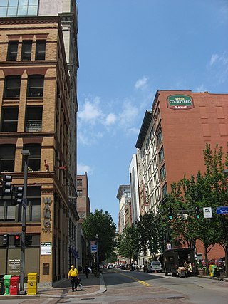
Downtown Pittsburgh, colloquially referred to as the Golden Triangle, and officially the Central Business District, is the urban downtown center of Pittsburgh, Pennsylvania, United States. It is located at the confluence of the Allegheny River and the Monongahela River whose joining forms the Ohio River. The triangle is bounded by the two rivers.

<span class="mw-page-title-main">Carnegie Library of Pittsburgh</span> Public library system in Pittsburgh, Pennsylvania

The Carnegie Library of Pittsburgh is the public library system in Pittsburgh, Pennsylvania. Its main branch is located in the Oakland neighborhood of Pittsburgh, and it has 19 branch locations throughout the city. Like hundreds of other Carnegie libraries, the construction of the main library, which opened in 1895, and several neighborhood branches, was funded by industrialist Andrew Carnegie. The Pittsburgh area houses the first branches in the United States.

<span class="mw-page-title-main">Bloomfield (Pittsburgh)</span> Neighborhood of Pittsburgh in Allegheny County, Pennsylvania, United States

Bloomfield is a neighborhood in Pittsburgh, Pennsylvania. It is located three miles from the downtown area. Bloomfield is sometimes referred to as Pittsburgh's Little Italy because it was settled by Italians from the Abruzzi region and has been a center of Italian–American population. Pittsburgh architectural historian Franklin Toker has said that Bloomfield "is a feast, as rich to the eyes as the homemade tortellini and cannoli in its shop windows are to the stomach." Recently, the neighborhood has attracted young adults and college students as a "hip" neighborhood.

<span class="mw-page-title-main">Friendship (Pittsburgh)</span> Neighborhood of Pittsburgh in Allegheny County, Pennsylvania, United States

Friendship is a neighborhood of large Victorian houses in the East End of the City of Pittsburgh, Pennsylvania, United States, about four miles (6 km) east of Pittsburgh's Golden Triangle. Friendship is bordered on the north by Garfield, on the east by East Liberty, on the south by Shadyside, and on the west by Bloomfield. It is divided into three Pittsburgh City Council districts.

<span class="mw-page-title-main">Central Lawrenceville</span> Neighborhood of Pittsburgh in Allegheny County, Pennsylvania, United States

Central Lawrenceville is a neighborhood in the northeast of Pittsburgh, Pennsylvania in the United States. It has a zip code of 15201, and has representation on Pittsburgh City Council by the council member for District 7. It is home to Allegheny Cemetery. Central Lawrenceville is the home of the Pittsburgh Bureau of Fire's 6 Engine and 6 Truck.

<span class="mw-page-title-main">Troy Hill (Pittsburgh)</span> Neighborhood of Pittsburgh in Allegheny County, Pennsylvania, United States

Troy Hill is a neighborhood on Pittsburgh, Pennsylvania's North Side. It has a zip code of 15212, and has representation on Pittsburgh City Council by the council member for District 1.

<span class="mw-page-title-main">National Register of Historic Places listings in Pennsylvania</span>

This is a list of properties and districts listed on the National Register of Historic Places in Pennsylvania. As of 2015, there are over 3,000 listed sites in Pennsylvania. All 67 counties in Pennsylvania have listings on the National Register.

UPMC St. Margaret is a mid-sized, acute care, teaching community hospital of the University of Pittsburgh Medical Center, located in the Lincoln–Lemington–Belmar neighborhood of Pittsburgh, Pennsylvania, adjacent to the borough of Aspinwall. Situated on 21 acres (8.5 ha), the hospital has 249 beds with more than 800 physicians and 1,500 clinical staff members. In March 2009, UPMC St. Margaret achieved Magnet Recognition status. Magnet status is the highest international recognition for nursing excellence and leadership.

<span class="mw-page-title-main">Penn Avenue</span>

Penn Avenue is a major arterial street in Pittsburgh and Wilkinsburg, in Pennsylvania. Its western terminus lies at Gateway Center in downtown Pittsburgh. For its westernmost ten blocks it serves as the core of the Cultural District with such attractions as Heinz Hall, the Benedum Center and the Byham Theater as well as the David L. Lawrence Convention Center and the Heinz History Center bordering it. Exiting downtown it is the major route through the city's Strip District, Lawrenceville, Bloomfield, Garfield and East Liberty neighborhoods. Its eastern portion exits the city at Wilkinsburg where it continues to exist as Penn Avenue with a numbering system that begins anew using small numbers as it approaches Interstate 376 the "Parkway East". Penn Avenue is about 8.7 miles (14.0 km) long.

<span class="mw-page-title-main">Allegheny Arsenal</span> Supply center for the Union Army during the American Civil War in Lawrenceville, PA

The Allegheny Arsenal, established in 1814, was an important supply and manufacturing center for the Union Army during the American Civil War, and the site of the single largest civilian disaster during the war. It was located in the community of Lawrenceville, Pennsylvania, which was annexed by the city of Pittsburgh in 1868.

<span class="mw-page-title-main">Washington Crossing Bridge (Pittsburgh)</span> Bridge in Pittsburgh and Millvale

The Washington Crossing Bridge, commonly known as the Fortieth Street Bridge, is an arch bridge that carries vehicular traffic across the Allegheny River between the Pittsburgh neighborhood of Lawrenceville and the suburb of Millvale. The bridge is decorated with the seals representing the original 13 colonies of the US and that of Allegheny county.

Collins Township was a township in Allegheny County, Pennsylvania, in the northeast part of what is now Pittsburgh. It included most of the present city east of Lawrenceville, north of Penn Avenue, and south of the Allegheny River. It was formed in 1850 from a northern portion of Peebles Township and was named for Thomas Collins, a prominent lawyer. On 30 June 1868, Collins Township along with the borough of Lawrenceville and the townships of Pitt, Oakland, Liberty, and Peebles were incorporated into Pittsburgh. The former Collins Township became wards 18, 19, and 21 of the expanded city.

The Turkey Devonshire sandwich, sometimes simply called a Devonshire, originated in 1934 in Pittsburgh, Pennsylvania. It is typically served as a hot open-faced sandwich on toasted bread with hot turkey, bacon, tomatoes, and a cheese sauce. The sandwich is similar to a Kentucky Hot Brown.

<span class="mw-page-title-main">Butler Street</span>

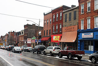
Butler Street is a street in Pittsburgh, Pennsylvania which is the main commercial thoroughfare of the Lawrenceville neighborhood. Since the early 2000s, it has become a center for arts, dining, and music, with many local businesses including bars, restaurants, breweries, and specialty shops. It is named for the city of Butler, Pennsylvania, whose namesake was Maj. Gen. Richard Butler of the Continental Army.

<span class="mw-page-title-main">Lawrenceville Historic District (Pittsburgh, Pennsylvania)</span> Historic district in Pennsylvania, United States

The Lawrenceville Historic District is a U.S. historic district in Pittsburgh, Pennsylvania, which encompasses the majority of the Lawrenceville neighborhood. The historic district includes 3,217 contributing resources, many of which are rowhouses, commercial buildings, and former industrial properties built between the 1830s and early 20th century. The district was listed on the National Register of Historic Places in 2019.

References

  1. 1 2 3 4 5 6 "PGHSNAP 2010 Raw Census Data by Neighborhood". Pittsburgh Department of City Planning. 2012. Retrieved June 28, 2013.
  2. Belser, Ann (March 22, 2011). "Businesses lured to Lawrenceville's new life". Pittsburgh Post-Gazette. Retrieved November 20, 2020.
  3. "Weekly List 20190712". National Register of Historic Places. National Park Service . Retrieved July 19, 2019.
  4. Bloom, Albert W. (January 14, 1953). "Pittsburgh today made up of many villages". Pittsburgh Post-Gazette. p. 23. Retrieved December 2, 2015.
  5. Negley, W. B. (1876). "Allegheny County; its Formation, its Cities, Wards, Boroughs and Townships". Atlas of the County of Allegheny, Penna. Philadelphia: G.M. Hopkins & Co. p. 4.
  6. O'Neill, Brian (May 15, 2011). "Passions stirred anew for an old log house". Pittsburgh Post-Gazette .
  7. "Ward 15". G.M. Hopkins & Co., Philadelphia. 1872. Retrieved April 18, 2010.
  8. "Lawrenceville: Washington Crossing Bridge". Carnegie Library of Pittsburgh. Archived from the original on January 3, 2011. Retrieved August 28, 2011.
  9. "Fifteenth Ward, Pittsburgh" (Map). Atlas of the Cities of Pittsburgh, Allegheny, and the Adjoining Boroughs. Philadelphia: G. M. Hopkins & Co. 1872. pp. 51–52.
  10. "Parts of Wards 12, 15 & 16, Pittsburgh" (Map). Atlas of the Cities Pittsburgh and Allegheny. Philadelphia: G. M. Hopkins & Co. 1882. p. 8.
  11. Evans, Mark A. "Site: PGHBW 4-3: A View of the Point from Grandview Avenue, Pittsburgh, PA". University of Pittsburgh. Archived from the original on March 31, 2012. Retrieved August 28, 2011.
  12. Children’s Hospital of Pittsburgh of UPMC Completes Historic Move to Lawrenceville With Successful Patient Relocation Archived July 28, 2012, at archive.today Retrieved June 2, 2009
  13. "A Design District Takes Shape", Jeff Schlegel, The New York Times, October 14, 2007.
  14. Machosky, Michael (March 27, 2013). "Restaurant restoration: Lawrenceville's Butler Street caters to foodies". Pittsburgh Tribune-Review . Retrieved April 4, 2013.
  15. "Arsenal Bowl". Arsenal Bowl. Retrieved November 18, 2016.
  16. "Row House Cinema seeks to change how Pittsburghers watch movies". Pittsburgh Post-Gazette. Retrieved November 18, 2016.
  17. "History | Art All Night | Lawrenceville". artallnight.org. Retrieved November 18, 2016.
  18. "Real estate prices higher in some places", Tim Grant, Pittsburgh Post-Gazette, November 2, 2007.
  19. "Homes in Lawrenceville so desirable that investors even fight over dilapidated shells". Pittsburgh Post-Gazette. Retrieved November 18, 2016.
  20. "'New' Lawrenceville is coping with its own success". Pittsburgh Post-Gazette. Retrieved November 18, 2016.
  21. Montanez, Virginia (November 11, 2010). "Jake, Call Me". Pittsburgh Magazine. Retrieved April 30, 2013.
  22. Ritenbaugh, Stephanie (October 24, 2023). "Tech startup for sexual assault survivors moves to Lawrenceville". TribLIVE.com. Retrieved October 26, 2023.

Further reading

Commons-logo.svg Media related to Lawrenceville (Pittsburgh) at Wikimedia Commons

40°27′55″N79°57′56″W / 40.46525°N 79.96543°W / 40.46525; -79.96543