
Philadelphia County is the most populous county in Pennsylvania and the 24th-most populous county in the nation. As of the 2020 census, the county had a population of 1,603,797. Its county seat is Philadelphia, the nation's sixth-largest city. The county is part of the Southeast Pennsylvania region of the state.

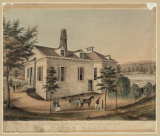
Roxborough is a neighborhood in Northwest Philadelphia, Pennsylvania, United States. It is bordered to the southwest, along the Schuylkill River, by the neighborhood of Manayunk, along the northeast by the Wissahickon Creek section of Fairmount Park, and to the southeast by the neighborhood of East Falls. Beyond Roxborough to the northwest is Montgomery County. Roxborough's ZIP Code is 19128. Most of Roxborough is in Philadelphia's 21st Ward.
Kingsessing is a neighborhood in the Southwest section of Philadelphia, Pennsylvania, United States. On the west side of the Schuylkill River, it is next to the neighborhoods of Cedar Park, Southwest Schuylkill, and Mount Moriah, as well as the borough of Yeadon in Delaware County. It is roughly bounded by 53rd Street to the northeast, Baltimore Avenue to the northwest, Cobbs Creek and 60th Street to the southwest, and Woodland Avenue to the southeast.

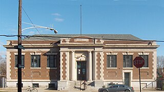
Northern Liberties is a neighborhood in Philadelphia, Pennsylvania, United States. It is north of Center City along the Delaware River. Prior to its incorporation into Philadelphia in 1854, it was among the top 10 largest cities in the U.S. in every census from 1790 to 1850. It was a major manufacturing area that attracted many European immigrants in the late 19th and early 20th centuries. In the early 21st century, it has attracted many young professionals and new commercial and residential development.
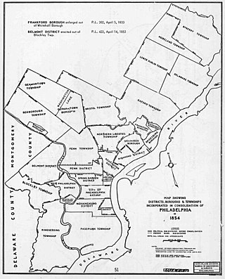
The Act of Consolidation, more formally known as the act of February 2, 1854, is legislation of the Pennsylvania General Assembly that created the consolidated City and County of Philadelphia, expanding the city's territory to the entirety of Philadelphia County and dissolving the other municipal authorities in the county.

Southwark was originally the Southwark District, a colonial-era municipality in Philadelphia County, Pennsylvania, United States. Today, it is a neighborhood in the South Philadelphia section of Philadelphia, Pennsylvania. Because of its location south of the early Philadelphia, the name was adopted in allusion to the borough of Southwark in the county of London, England, just south of the city of London.

Moyamensing is an area of Philadelphia established as a Moyamensing Township during British colonial rule on the fast land of the Neck, lying between Passyunk and Wicaco. It was incorporated into Philadelphia County, Pennsylvania, United States and today encompasses several neighborhoods along the Moyamensing Avenue corridor in the South Philadelphia section of Philadelphia.
Northern Liberties Township was a township that was located in Philadelphia County, Pennsylvania. The township was later incorporated into the City of Philadelphia after the passage of the Act of Consolidation, 1854.
Aramingo Borough was a borough that was located in Philadelphia County, Pennsylvania, United States. The borough ceased to exist and was incorporated into the City of Philadelphia following the passage of the Act of Consolidation, 1854.

Blockley Township was a township that was located in Philadelphia County, Pennsylvania, United States. Incorporated in 1704, the township was incorporated into the City of Philadelphia under the 1854 Act of Consolidation.
Delaware Township was a township that was located in Philadelphia County, Pennsylvania, United States. The borough ceased to exist and was incorporated into the City of Philadelphia following the passage of the Act of Consolidation, 1854.
Moreland Township was a township that was located in Philadelphia County, Pennsylvania, United States.

Oxford Township was a township in Philadelphia County, Pennsylvania, United States. The township ceased to exist and was incorporated into the City of Philadelphia following the passage of the Act of Consolidation, 1854.

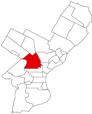
Penn District was a district located in Philadelphia County, Pennsylvania, United States. The district ceased to exist and was incorporated into the City of Philadelphia following the passage of the Act of Consolidation, 1854.
Penn Township was a township that was located in Philadelphia County, Pennsylvania. The township ceased to exist and was incorporated into the City of Philadelphia following the passage of the Act of Consolidation, 1854.

Richmond District, also known as Port Richmond District, was a district that was located in Philadelphia County, Pennsylvania, United States. The district ceased to exist and was incorporated into the City of Philadelphia following the passage of the Act of Consolidation, 1854.
West Philadelphia Borough, also known as West Philadelphia District, was a borough that was located west of the Schuylkill River in Blockley Township, Philadelphia County, Pennsylvania, United States. The borough ceased to exist and was incorporated into the City of Philadelphia following the passage of the Act of Consolidation, 1854.
Whitehall Borough was a borough that was located in Philadelphia County, Pennsylvania, United States. The borough ceased to exist when it was incorporated into the City of Philadelphia on the passage of the Act of Consolidation, 1854.
Lower Dublin Township, also known as Dublin Township, was a township that was located in Philadelphia County, Pennsylvania, United States. The township ceased to exist and was incorporated into the City of Philadelphia following the passage of the Act of Consolidation, 1854.


