
Wyncote is a census-designated place (CDP) in Cheltenham Township, Montgomery County, Pennsylvania. It borders the northwestern and northeastern section of Philadelphia. Wyncote is located 11 miles from Center City Philadelphia at the southeasternmost tip of Montgomery County. The Jenkintown-Wyncote SEPTA station is the fifth busiest regional rail station in the SEPTA system.

Germantown is an area in Northwest Philadelphia. Founded by German, Quaker, and Mennonite families in 1683 as an independent borough, it was absorbed into Philadelphia in 1854. The area, which is about six miles northwest from the city center, now consists of two neighborhoods: 'Germantown' and 'East Germantown'.
Chestnut Hill is a neighborhood in the Northwest Philadelphia section of Philadelphia, Pennsylvania. It is known for the high incomes of its residents and high real estate values, as well as its private schools.

Fern Rock is a neighborhood in the upper North Philadelphia section of Philadelphia, Pennsylvania bounded by Olney to the east, Ogontz to the west, Logan to the south, and East Oak Lane to the north. It is approximately situated between Broad Street, Tabor Road, 7th Street, Godfrey Avenue and Fisher Park. Fern Rock borders Ogontz at Broad Street, Logan at Olney Avenue, East Oak Lane at Godfrey Avenue, and Olney at the train tracks.

North Philadelphia, nicknamed North Philly, is a section of Philadelphia, Pennsylvania. It is immediately north of Center City. Though the full extent of the region is somewhat vague, "North Philadelphia" is regarded as everything north of either Vine Street or Spring Garden Street, between Northwest Philadelphia and Northeast Philadelphia. It is bordered to the north by Cheltenham Township along Cheltenham Avenue, Spring Garden Street to the south, 35th Street to the west and Adams Avenue to the east. The Philadelphia Police Department patrols five districts located within North Philadelphia: the 22nd, 25th, 26th, 35th and 39th districts. There are fifteen ZIP codes for North Philadelphia: 19120, 19121, 19122, 19123, 19125, 19126, 19130, 19132, 19133, 19134, 19137, 19138, 19140, 19141, and 19150.

Mount Airy is a neighborhood of Northwest Philadelphia in the U.S. state of Pennsylvania.

Ogontz/Belfield is a neighborhood in Upper Northern Philadelphia that is located adjacent to West Oak Lane, East Germantown, Logan, and Fern Rock, Philadelphia.

Northwest Philadelphia is a section of the city of Philadelphia. The official boundary is Stenton Avenue to the north, the Schuylkill River to the southwest, Northwestern Avenue to the northwest, Roosevelt Boulevard to the south, and Wister Street and Stenton Avenue to the east. The area is divided by Wissahickon Creek into two subsections, Upper Northwest and Lower Northwest Philadelphia. Upper Northwest are Germantown, Mount Airy, Chestnut Hill, and Cedarbrook; Lower Northwest are Roxborough, Wissahickon, East Falls, and Manayunk. The area of Philadelphia west of the Schuylkill River is known as West Philadelphia. The Philadelphia Police Department patrols two districts located within Northwest Philadelphia. The two patrol districts serving Northwest Philadelphia are the 5th and 14th districts.
Logan is a neighborhood in the upper North Philadelphia section of the city of Philadelphia, in the U.S. state of Pennsylvania. The majority of the neighborhood falls within the 19141 zip code, but some of it falls within 19140. The neighborhood is sometimes confused with the Olney neighborhood of Philadelphia. Olney Avenue extends from both the Olney and Logan neighborhoods of the city. The Olney Transportation Center is located in Logan.
Cedarbrook is a neighborhood located in the Northwest section of the City of Philadelphia.
Bristol Township is a defunct township that was located in Philadelphia County, Pennsylvania. The township ceased to exist and was incorporated into the City of Philadelphia following the passage of the Act of Consolidation, 1854. It is the modern day Olney-Oak Lane Planning Analysis Section, though with a slight difference in the southern border. It is in present-day North Philadelphia, although Olney-Oak Lane is sometimes considered to be separate from North Philadelphia entirely because of their unique architecture, culture and differing patterns of development.
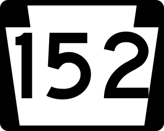
Pennsylvania Route 152 (PA 152) is a 25.3-mile-long (40.7 km) state highway located in the U.S. state of Pennsylvania. The route travels north–south from an interchange with PA 309 located in the Cedarbrook neighborhood of Cheltenham Township in Montgomery County north to another interchange with PA 309 located northeast of Telford in Bucks County. PA 152 is known as Limekiln Pike for most of its length. From the southern terminus, the route passes through suburban areas to the north of Philadelphia, serving Dresher, Maple Glen, and Chalfont. North of Chalfont, PA 152 runs through rural suburbs of Philadelphia before reaching Silverdale. Past here, the road continues northwest through Perkasie, where it turns southwest and passes through Sellersville before reaching its northern terminus.
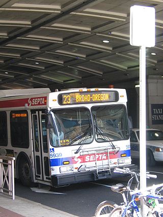
SEPTA Trolley Route 23 is a former streetcar line now operated with buses. It is operated by the Southeastern Pennsylvania Transportation Authority (SEPTA) in Philadelphia, Pennsylvania, United States. The line runs between the Chestnut Hill and Center City neighborhoods via Germantown Avenue, 11th, and 12th Streets.

SEPTA's Trolley Route 6, also known as the Ogontz Avenue Line is a former streetcar line and current bus route, operated by the Southeastern Pennsylvania Transportation Authority (SEPTA) in Philadelphia, Pennsylvania, United States.
Olney-Oak Lane, Philadelphia, is a section of Philadelphia that is immediately north of Upper North Philadelphia and south of Cheltenham. It is an area that consists of the now defunct township that was called "Bristol Township, Philadelphia County, Pennsylvania". The section is often included as part of North Philadelphia by city government agencies, though locally it is often referred to as "Uptown," along with the Germantown-Chestnut Hill section.
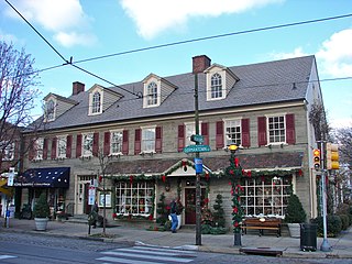
The Germantown-Chestnut Hill section of Philadelphia is about 7–8 miles northwest from the center of the city. The neighborhood of Germantown is rich in historic sites and buildings from the colonial era, a few of which are open to the public.
Cheltenham Avenue is a major east-west road in Southeastern Pennsylvania. It is served by many SEPTA bus routes, trolleys, regional rail, and subway. Cheltenham Avenue is an unsigned quadrant route t routes in Montgomery County, Pennsylvania. It also is a major borderline; it defines the border between Springfield and Cheltenham townships, and Cheltenham Township and the City of Philadelphia, with the latter also being the Montgomery County and Philadelphia County. A section of the road along the Philadelphia–Cheltenham border is part of PA Route 309.

Cheltenham Township is a home rule township in Montgomery County, Pennsylvania, United States. Cheltenham's population density ranges from over 10,000 per square mile in rowhouses and high-rise apartments along Cheltenham Avenue to historic neighborhoods in Wyncote and Elkins Park. It is the most densely populated township in Montgomery County. The population was 36,793 at the 2010 U.S. Census, making it the third most populous township in Montgomery County and the 27th most populous municipality in Pennsylvania. It was originally part of Philadelphia County, and it became part of Montgomery County upon that county's creation in 1784.
Germantown Pike is a historic road in Pennsylvania that opened in 1687, running from Philadelphia northwest to Collegeville. The road is particularly notable for the "imposing mansions" that existed in the Germantown neighborhood in Philadelphia. The road was left in ruins after the British destroyed it in the Revolutionary War during the 1777 Battle of Germantown, and was not rebuilt until 1809. Portions of Germantown Pike were signed as U.S. Route 422 (US 422) before the latter was rerouted along a freeway alignment to King of Prussia.

