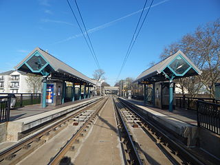
Garfield Avenue station is a station on the Hudson–Bergen Light Rail (HBLR) in the Claremont section of Jersey City, Hudson County, New Jersey. Located between the grade crossing at Randolph Avenue and the bridge at Garfield Avenue, the station in a double side platform and two track structure. The station is on the West Side Avenue branch of the Hudson–Bergen Light Rail, which goes from West Side Avenue station to Tonnelle Avenue station in North Bergen. The station is accessible for handicapped people as per the Americans with Disabilities Act of 1990. An elevator is present to get people from Garfield Avenue to track level and the platforms are even with the train cars. The station opened to the public on April 15, 2000 as part of the original operating segment of the Hudson–Bergen Light Rail.

West Side Avenue station is a station on the Hudson–Bergen Light Rail (HBLR) in the West Side neighborhood in Jersey City, New Jersey. Located on the east side of West Side Avenue, the station is the terminal of the West Side Avenue branch of the Hudson–Bergen Light Rail, with service to Tonnelle Avenue station in North Bergen. The station consists of a single island platform and a pair of tracks that end at the station. The station contains a pedestrian bridge over West Side Avenue to a small parking lot and bus stop on the west side of the street. The station is accessible to people with disabilities, with an elevator in the pedestrian overpass and train-level platforms. West Side Avenue station opened on April 15, 2000 as part of the original operating segment of the Hudson–Bergen Light Rail.

Greenville is the southernmost section of Jersey City in Hudson County, in the U.S. state of New Jersey.

Five Corners is a neighborhood located at the intersection of Summit Avenue, Newark Avenue, and Hoboken Avenue in Jersey City, in the U.S. state of New Jersey, and is situated in the northeastern portion of the larger Journal Square district. The name of the intersection is used for the neighborhood radiating from the crossing, which is adjacent to the Hilltop, just south of Bergen Arches and The Divided Highway.

Bergen Hill refers to the lower Hudson Palisades in New Jersey, where they emerge on Bergen Neck, which in turn is the peninsula between the Hackensack and Hudson Rivers, and their bays. In Hudson County, it reaches a height of 260 feet.
Communipaw is a neighborhood in Jersey City in Hudson County, in the U.S. state of New Jersey. It is located west of Liberty State Park and east of Bergen Hill, and the site of one of the earliest European settlements in North America. It gives its name to the historic avenue which runs from its eastern end near Liberty State Park Station through the neighborhoods of Bergen-Lafayette and the West Side that then becomes the Lincoln Highway. Communipaw Junction, or simply The Junction, is an intersection where Communipaw, Summit Avenue, Garfield Avenue, and Grand Street meet, and where the toll house for the Bergen Point Plank Road was situated. Communipaw Cove at Upper New York Bay, is part of the 36-acre (150,000 m2) state nature preserve in the park and one of the few remaining tidal salt marshes in the Hudson River estuary.
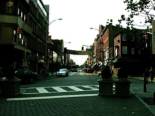
Harsimus is a neighborhood within Downtown Jersey City, Hudson County, in the U.S. state of New Jersey. The neighborhood stretches from the Harsimus Stem Embankment on the north to Christopher Columbus Drive on the south between Coles Street and Grove Street or more broadly, to Marin Boulevard. It borders the neighborhoods of Hamilton Park to the north, Van Vorst Park to the south, the Village to the west, and the Powerhouse Arts District to the east. Newark Avenue has traditionally been its main street. The name is from the Lenape, used by the Hackensack Indians who inhabited the region and could be translated as Crow's Marsh. From many years, the neighborhood was part of the "Horseshoe", a political delineation created by its position between the converging rail lines and political gerrymandering.

Van Vorst Park is a neighborhood in the Historic Downtown of Jersey City, Hudson County, New Jersey, centered on a park sharing the same name. The neighborhood is located west of Paulus Hook and Marin Boulevard, north of Grand Street, east of the Turnpike Extension, and south of The Village and Christopher Columbus Drive. Much of it is included in the Van Vorst Park Historical District.
Curries Woods is a neighborhood in the southern part of Greenville in Jersey City, New Jersey bordering Bayonne. It was named after James Curie, who was on the town Committee for Greenville when it was its own Township in the 19th century. The area remained rural until the later part of the century when the Central Railroad of New Jersey built a line connecting ferries to Elizabeth, New Jersey and New York City. Currie's Woods still remained untouched through the late part of the century and it was valued for its woods, rocky shore and dunes on Newark Bay. A lot of the land was eventually lost, but a tract was set aside in the early part of the 20th century. A small cemetery, the Old Greenville Cemetery, was nearby. This park lost much of its land to the city's largest Housing Authority project in 1959, except a small tract in Bayonne, Mercer Park.
Bergen-Lafayette is a section of Jersey City, New Jersey.

The West Side of Jersey City is an area made up of several diverse neighborhoods on either side of West Side Avenue, one of the city's main shopping streets. Parallel and west of Kennedy Boulevard, West Side Avenue carries two county route designations.

Hudson County, New Jersey has historic districts which have been designated as such on a municipal, state, or federal level, or combination therof. Some are listed on New Jersey Register of Historic Places and are included on National Register of Historic Places listings in Hudson County, New Jersey. The following is intended to be a list of places which encompasses an area or group of buildings or structures.

County Route 617 is 4.55-mile (7.32 km) long and follows one street, Summit Avenue along the ridge of the Hudson Palisades in Hudson County, New Jersey. Its southern end is CR 622, or Grand Street, at Communipaw Junction in the Bergen-Lafayette Section of Jersey City. Its northern end is CR 691, 32nd Street, a section of the Bergen Turnpike, in Union City.

Martin Luther King Drive station is a station of the Hudson–Bergen Light Rail in the Jackson Hill neighborhood of Jersey City, Hudson County, New Jersey. Located on the east side of Martin Luther King Drive near the intersection with Virginia Avenue, the station is a two side platform, two track structure on the West Side Avenue branch of the Hudson–Bergen Light Rail. Train service through Martin Luther King Drive station goes from West Side Avenue in Jersey City to the Tonnelle Avenue station in North Bergen. The station is accessible for those with disabilities as part of the Americans with Disabilities Act of 1990 with ramps to the train-level platform. Martin Luther King Drive station opened on April 15, 2000 along with the rest of the West Side Avenue branch as part of the original operating segment.

Nungessers is the name of the confluence of roads that meet at the Hudson and Bergen county line at North Bergen and Fairview in northeastern New Jersey. The area is the former site of the Nungesser's Gutenberg Racetrack, a late 19th-century gaming and gambling venue. The neighborhood just south of Nungesser's is called the Racetrack Section and the municipality of Guttenberg is nearby. A White Castle, an early drive-in fast-food chain, originally built in the 1930s has long been a landmark in the neighborhood, as has adjacent North Hudson Park.

The Bergen Section of Jersey City, New Jersey is the neighborhood on either side of Kennedy Boulevard between Saint Peter's College/ McGinley Square and Communipaw Avenue in the Bergen-Lafayette section of the city. The name Bergen, used throughout Hudson County, is taken from the original Bergen, New Netherland settlement at Bergen Square.

The Newark and New York Railroad was a passenger rail line that ran between Downtown Newark and the Communipaw Terminal at the mouth of the North River in Jersey City, bridging the Hackensack River and Passaic River just north of their mouths at the Newark Bay in northeastern New Jersey. The Central Railroad of New Jersey operated it from its opening in 1869. Though operations ended in 1946; portions remained in use until 1967.

Jackson Hill is a neighborhood in the Bergen-Lafayette and Greenville sections of Jersey City, New Jersey. It is part of the city's Ward F. The neighborhood is situated on Bergen Hill which also lends its name to the Bergen Hill Historic District just north of Communipaw Avenue.