Bergen-Lafayette, Jersey City

Last updated

Bergen-Lafayette is a section of Jersey City, New Jersey. [1]

Contents

As its name implies, Bergen-Lafayette is made of different neighborhoods. It lies west-southwest of Downtown and Liberty State Park. Its less-defined other borders overlap those of Greenville at Hudson-Bergen Light Rail to the south, Lincoln Park/West Bergen to the west, and Montgomery Street at McGinley Square to the north.

The name Bergen, used throughout Hudson County, is taken from the original Bergen, New Netherland settlement at Bergen Square. The district can correspond to the former Bergen City, which existed from 1855 to 1870 and was originally incorporated as a town by an Act of the New Jersey Legislature on March 24, 1855, from portions of Bergen Township. In 1862, it did a reverse takeover, absorbing the remaining portions Bergen Township. On April 14, 1863, portions of the town were taken to form Greenville Township. Bergen was reincorporated as a city on March 11, 1868. [2] On May 2, 1870, both Bergen City and Hudson City elected to merge with Jersey City. [2]

Bergen

Restored Victorian mansions on Bergen Avenue BergenAve Victorians.jpg
Restored Victorian mansions on Bergen Avenue

Kennedy Boulevard and Bergen Avenue are a major north-south thoroughfares in the city running south from Journal Square along the ridge of the diminishing Hudson Palisades A variety of architectural styles can be found along these streets and their sidestreets including 19th-century rowhouses, Victorian mansions, and pre-war and Art Deco apartment buildings, and the Renaissance Revival former Jersey City YMCA. Monticello Avenue is a shopping district [3] lined with many turn-of-the-century buildings with storefronts being brought back into use. The Fairmount Apartments and Temple Beth-El are a prominent landmark on Kennedy Boulevard. Lincoln the Mystic , a statue of a seated Abraham Lincoln by James Earle Fraser, is situated at its Boulevard entrance. As its name suggests West Bergen overlaps this neighborhood. The city is now defining this area with maps and other promotions to encourage use of the name McGinley Square.

Beacon

In 2005 the former Jersey City Medical Center was renovated and restored as The Beacon, with approximately 1,200 new residences. The 14-acre (57,000 m2) site is located at the northwest corner of the district atop Bergen Hill east of McGinley Square.

The Junction, Bergen Hill, and Jackson Hill

Grand street ascending hill at Arlington Park Bergen Hill, Jersey city looking north on Grand St-Arlington Park.jpg
Grand street ascending hill at Arlington Park

Communipaw Junction, or simply, The Junction, is where Communipaw, Summit Avenue and Garfield Avenue, and Grand Street meet. The Bergen Hill Historic District [4] is centered on Summit Avenue as it ascends from the Junction. Bergen Hill, or The Hill, [5] refers to the emergence of the New Jersey Palisades. The district is not on National Register of Historic Places, but has a state designation. a prominent landmark being St John's Church. [6] Lincoln High School is on Crescent Avenue. Ficken's Warehouse is on Grand Street, which as it ascends from the Junction to the St. Patrick's Parish and Buildings at Bramhall Ave. ( 40°42′50″N74°4′23″W / 40.71389°N 74.07306°W / 40.71389; -74.07306 ). While not in the city historic district, this complex received its federal historic status in September 1980 and anchors the surrounding streets, some of which are lined with well-preserved or restored 18th-century row houses in Jackson Hill. MLK Drive has long been a commercial street for the southern part of the district. The neighborhood sometimes called Claremont lies south of Arlington Park, where before discontinuation of service the Central Railroad of New Jersey maintained station.

Communipaw-Lafayette

Gazebo at Lafayette Park Lafayette Park-Communipaw-Lafayette Jersey City gazebo.jpg
Gazebo at Lafayette Park

Lafayette Park gives its name to the lower, or eastern, portion of the district closest to Downtown Jersey City. It is likely named for the Marquis de Lafayette, who was stationed in Bergen in 1799, and later re-visited in 1824 [7] [8] A city square similar to Van Vorst Park and Hamilton Park the buildings surrounding it were constructed in different periods. Before land-filling in the early twentieth century this area was located on the Upper New York Bay. The Hackensack Indian village of Communipaw and the 16th century New Netherland plantation of Jan Everts Bout, site of the Pavonia Massacre, were located here. Whitlock Cordage [9] is an intact complex of industrial buildings built in the Lafayette section along the banks of the Morris Canal. [10] [11] The Housing Trust of America purchased the property to preserve the structures as affordable housing. Parts of the neighborhood are part of the Communipaw-Lafayette Historic District. [12] Berry Lane Park, which upon completion will be the largest municipal park in Jersey City, is under construction along Garfield Avenue.

Transportation

The Liberty State Park, Garfield Avenue, and Martin Luther King stations of the Hudson-Bergen Light Rail are on the periphery of the section. New Jersey Transit bus routes 6, 8, 81, 87 to Journal Square, Exchange Place, and Hoboken Terminal serve the area locally.

See also

Related Research Articles

<span class="mw-page-title-main">Garfield Avenue station</span> Garfield Avenue Station Hudson-Bergen Light Rail (HBLR) New Jersey Transit Rail

Garfield Avenue station is a station on the Hudson–Bergen Light Rail (HBLR) in the Claremont section of Jersey City, Hudson County, New Jersey. Located between the grade crossing at Randolph Avenue and the bridge at Garfield Avenue, the station in a double side platform and two track structure. The station is on the West Side Avenue branch of the Hudson–Bergen Light Rail, which goes from West Side Avenue station to Tonnelle Avenue station in North Bergen. The station is accessible for handicapped people as per the Americans with Disabilities Act of 1990. An elevator is present to get people from Garfield Avenue to track level and the platforms are even with the train cars. The station opened to the public on April 15, 2000 as part of the original operating segment of the Hudson–Bergen Light Rail.

<span class="mw-page-title-main">Greenville, Jersey City</span> Populated place in Hudson County, New Jersey, US

Greenville is the southernmost section of Jersey City in Hudson County, in the U.S. state of New Jersey.

<span class="mw-page-title-main">The Heights, Jersey City</span> District of Jersey City, New Jersey, United States

The Heights or Jersey City Heights is a neighborhood in Jersey City, New Jersey, located atop the New Jersey Palisades, along the west side of the Hudson River. It is bound by Paterson Plank Road on the north, Highway 139 on the south, Hoboken on the east, and the Hackensack River on the west. and Penhorn Creek on the west. Its postal area ZIP Codes are 07307, and portions of 07306.

<span class="mw-page-title-main">Five Corners, Jersey City</span> Populated place in Hudson County, New Jersey, US

Five Corners is a neighborhood located at the intersection of Summit Avenue, Newark Avenue, and Hoboken Avenue in Jersey City, in the U.S. state of New Jersey, and is situated in the northeastern portion of the larger Journal Square district. The name of the intersection is used for the neighborhood radiating from the crossing, which is adjacent to the Hilltop, just south of Bergen Arches and The Divided Highway.

<span class="mw-page-title-main">Hackensack Plank Road</span>

The Hackensack Plank Road, also known as Bergen Turnpike, was a major artery which connected the cities of Hoboken and Hackensack, New Jersey. Like its cousin routes, the Newark Plank Road and Paterson Plank Road, it travelled over Bergen Hill and across the Hackensack Meadows from the Hudson River waterfront to the city for which it was named. It was originally built as a colonial turnpike road as Hackensack and Hoboken Turnpike. The route mostly still exists today, though some segments are now called the Bergen Turnpike. It was during the 19th century that plank roads were developed, often by private companies which charged a toll. As the name suggests, wooden boards were laid on a roadbed in order to prevent horse-drawn carriages and wagons from sinking into softer ground on the portions of the road that passed through wetlands. The company that built the road received its charter on November 30, 1802. The road followed the route road from Hackensack to Communipaw that was described in 1679 as a "fine broad wagon-road."

<span class="mw-page-title-main">Bergen Hill</span> Lower part of the Hudson Palisades, New Jersey, United States

Bergen Hill refers to the lower Hudson Palisades in New Jersey, where they emerge on Bergen Neck, which in turn is the peninsula between the Hackensack and Hudson Rivers, and their bays. In Hudson County, it reaches a height of 260 feet.

Communipaw is a neighborhood in Jersey City in Hudson County, in the U.S. state of New Jersey. It is located west of Liberty State Park and east of Bergen Hill, and the site of one of the earliest European settlements in North America. It gives its name to the historic avenue which runs from its eastern end near Liberty State Park Station through the neighborhoods of Bergen-Lafayette and the West Side that then becomes the Lincoln Highway. Communipaw Junction, or simply The Junction, is an intersection where Communipaw, Summit Avenue, Garfield Avenue, and Grand Street meet, and where the toll house for the Bergen Point Plank Road was situated. Communipaw Cove at Upper New York Bay, is part of the 36-acre (150,000 m2) state nature preserve in the park and one of the few remaining tidal salt marshes in the Hudson River estuary.

<span class="mw-page-title-main">Van Vorst Park</span> Populated place in Essex County, New Jersey, US

Van Vorst Park is a neighborhood in the Historic Downtown of Jersey City, Hudson County, New Jersey, centered on a park sharing the same name. The neighborhood is located west of Paulus Hook and Marin Boulevard, north of Grand Street, east of the Turnpike Extension, and south of The Village and Christopher Columbus Drive. Much of it is included in the Van Vorst Park Historical District.

<span class="mw-page-title-main">McGinley Square</span> Populated place in Hudson County, New Jersey, US

McGinley Square is a neighborhood in Jersey City, New Jersey, located near the middle of the city, south of Journal Square. The square itself is at the intersection of two of the city's major thoroughfares, Montgomery Street, and Bergen Avenue.

<span class="mw-page-title-main">West Side, Jersey City</span> Populated place in Hudson County, New Jersey, US

The West Side of Jersey City is an area made up of several diverse neighborhoods on either side of West Side Avenue, one of the city's main shopping streets. Parallel and west of Kennedy Boulevard, West Side Avenue carries two county route designations.

<span class="mw-page-title-main">Historic districts in Hudson County, New Jersey</span> Historic districts in Hudson County, New Jersey, US

Hudson County, New Jersey has historic districts which have been designated as such on a municipal, state, or federal level, or combination therof. Some are listed on New Jersey Register of Historic Places and are included on National Register of Historic Places listings in Hudson County, New Jersey. The following is intended to be a list of places which encompasses an area or group of buildings or structures.

<span class="mw-page-title-main">Summit Avenue (Hudson Palisades)</span> Road in Hudson County, New Jersey, US

County Route 617 is 4.55-mile (7.32 km) long and follows one street, Summit Avenue along the ridge of the Hudson Palisades in Hudson County, New Jersey. Its southern end is CR 622, or Grand Street, at Communipaw Junction in the Bergen-Lafayette Section of Jersey City. Its northern end is CR 691, 32nd Street, a section of the Bergen Turnpike, in Union City.

<span class="mw-page-title-main">Martin Luther King Drive station</span> Martin Luther King Drive Station HBLR Hudson Bergen Light Rail NJ Transit Light Rail

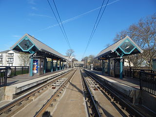
Martin Luther King Drive station is a station of the Hudson–Bergen Light Rail in the Jackson Hill neighborhood of Jersey City, Hudson County, New Jersey. Located on the east side of Martin Luther King Drive near the intersection with Virginia Avenue, the station is a two side platform, two track structure on the West Side Avenue branch of the Hudson–Bergen Light Rail. Train service through Martin Luther King Drive station goes from West Side Avenue in Jersey City to the Tonnelle Avenue station in North Bergen. The station is accessible for those with disabilities as part of the Americans with Disabilities Act of 1990 with ramps to the train-level platform. Martin Luther King Drive station opened on April 15, 2000 along with the rest of the West Side Avenue branch as part of the original operating segment.

<span class="mw-page-title-main">Bergen Point Plank Road</span>

The Jersey City and Bergen Point Plank Road was a road originally built in the 19th century in Hudson County, New Jersey, United States which ran between Paulus Hook and Bergen Point. The company that built the road received a charter on March 6, 1850 to improve one that had been built in the 18th century. It has subsequently become Grand Street and Garfield Avenue in Jersey City and Broadway in Bayonne. Plank roads were built during the 19th century, often by private companies as turnpike roads, in this case with a tollgate at Communipaw Junction. As the name suggests, wooden boards were laid on a roadbed in order to prevent horse-drawn carriages and wagons from sinking into softer ground on the portions of the road.

<span class="mw-page-title-main">Bergen Hill, Jersey City</span> Populated place in Hudson County, New Jersey, US

Bergen Hill is the name given to the emergence of the Hudson Palisades along the Bergen Neck peninsula in Hudson County, New Jersey and the inland neighborhood of Jersey City, New Jersey, where they rise from the coastal plain at the Upper New York Bay. The name is taken from the original 17th-century New Netherland settlement of Bergen, which in Dutch means hills.

<span class="mw-page-title-main">Bergen Section, Jersey City</span> Populated place in Hudson County, New Jersey, US

The Bergen Section of Jersey City, New Jersey is the neighborhood on either side of Kennedy Boulevard between Saint Peter's College/ McGinley Square and Communipaw Avenue in the Bergen-Lafayette section of the city. The name Bergen, used throughout Hudson County, is taken from the original Bergen, New Netherland settlement at Bergen Square.

<span class="mw-page-title-main">Jackson Hill, Jersey City</span> Populated place in Hudson County, New Jersey, US

Jackson Hill is a neighborhood in the Bergen-Lafayette and Greenville sections of Jersey City, New Jersey. It is part of the city's Ward F. The neighborhood is situated on Bergen Hill which also lends its name to the Bergen Hill Historic District just north of Communipaw Avenue.

References

  1. "Jersey City's Districts". Archived from the original on August 20, 2008. Retrieved March 9, 2009.
  2. 1 2 Snyder, John P. (1969). The Story of New Jersey's Civil Boundaries: 1606-1968. Bureau of Geology and Topography.
  3. "JC Shoppring Districts". Archived from the original on January 19, 2023. Retrieved August 20, 2009.
  4. "Jersey City - Historic Preservation Districts". Archived from the original on September 4, 2009. Retrieved June 7, 2009.
  5. Bergen [ permanent dead link ]
  6. "Campaign to Protect St. John's Episcopal Church". Archived from the original on April 29, 2010. Retrieved June 25, 2009.
  7. "Aplple Tree House". Archived from the original on July 14, 2009. Retrieved June 28, 2009.
  8. Harriet Phillips Eaton, Jersey City And Its Historic Sites, 1899:
  9. "Jersey City History: The Whitlock Cordage". The Jersey City Landmarks Conservancy. 2007. Archived from the original on September 26, 2009. Retrieved June 24, 2009.
  10. "In Bergen-Lafayette, a canal runs through it - the Real Deal".
  11. JC Online
  12. NJ State Register of Historic Places in Hudson County Archived July 5, 2010, at the Wayback Machine

40°43′32″N74°04′17″W / 40.72567°N 74.07138°W / 40.72567; -74.07138