Berkey, Ohio

Last updated

Berkey, Ohio
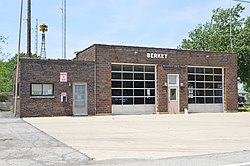
Berkey municipal building, front.jpg
Village Hall
Lucas County Ohio incorporated and unincorporated areas Berkey highlighted.svg
Location in Lucas County and the state of Ohio.
Coordinates: 41°42′30″N83°50′18″W / 41.70833°N 83.83833°W / 41.70833; -83.83833
Country United States
State Ohio
County Lucas
Area
[1]
  Total4.24 sq mi (10.98 km2)
  Land4.24 sq mi (10.98 km2)
  Water0.00 sq mi (0.00 km2)
Elevation
[2]
702 ft (214 m)
Population
 (2020)
  Total275
  Density64.87/sq mi (25.05/km2)
Time zone UTC-5 (Eastern (EST))
  Summer (DST) UTC-4 (EDT)
ZIP code
43504
Area code 419
FIPS code 39-05732 [3]
GNIS feature ID2398102 [2]
Website www.berkeyohio.org

Berkey is a village in Lucas County, Ohio, United States. The population was 275 at the 2020 census.

Contents

History

Berkey was originally called Riga. [4] The present name is derived from Richard K. Berkeybile, an early postmaster. [4] A post office called Riga was established in 1837, and the name was changed to Berkey in 1870. [5]

Geography

According to the United States Census Bureau, the village has a total area of 4.18 square miles (10.83 km2), all land. [6]

Demographics

Historical population
CensusPop.Note
1920 201
1930 26129.9%
1940 248−5.0%
1950 239−3.6%
1960 2577.5%
1970 29414.4%
1980 3064.1%
1990 264−13.7%
2000 2650.4%
2010 237−10.6%
2020 27516.0%
U.S. Decennial Census [7]

2010 census

At the 2010 census there were 237 people, 99 households, and 73 families living in the village. The population density was 56.7 inhabitants per square mile (21.9/km2). There were 112 housing units at an average density of 26.8 per square mile (10.3/km2). The racial makeup of the village was 99.2% White and 0.8% Asian. Hispanic or Latino of any race were 1.3%. [8]

Of the 99 households 28.3% had children under the age of 18 living with them, 63.6% were married couples living together, 9.1% had a female householder with no husband present, 1.0% had a male householder with no wife present, and 26.3% were non-families. 22.2% of households were one person and 11.2% were one person aged 65 or older. The average household size was 2.39 and the average family size was 2.77.

The median age in the village was 48.2 years. 21.1% of residents were under the age of 18; 5% were between the ages of 18 and 24; 18.6% were from 25 to 44; 37.2% were from 45 to 64; and 18.1% were 65 or older. The gender makeup of the village was 51.1% male and 48.9% female.

2000 census

At the 2000 census there were 265 people, 98 households, and 81 families living in the village. The population density was 63.5 inhabitants per square mile (24.5/km2). There were 100 housing units at an average density of 23.9 per square mile (9.2/km2). The racial makeup of the village was 98.11% White, 0.75% Native American, 0.38% Asian, and 0.75% from two or more races. Hispanic or Latino of any race were 0.38%. [3]

Of the 98 households 39.8% had children under the age of 18 living with them, 69.4% were married couples living together, 10.2% had a female householder with no husband present, and 17.3% were non-families. 15.3% of households were one person and 8.2% were one person aged 65 or older. The average household size was 2.70 and the average family size was 3.04.

The age distribution was 29.4% under the age of 18, 3.8% from 18 to 24, 30.2% from 25 to 44, 25.3% from 45 to 64, and 11.3% 65 or older. The median age was 37 years. For every 100 females there were 90.6 males. For every 100 females age 18 and over, there were 94.8 males.

The median household income was $60,500 and the median family income was $65,313. Males had a median income of $46,000 versus $31,875 for females. The per capita income for the village was $25,944. None of the population or families were below the poverty line.
Related Research Articles

Bradley is a town in Penobscot County, Maine, United States. It is part of the Bangor Metropolitan Statistical Area. The population was 1,532 at the 2020 census. The village of Bradley is in the northwestern corner of the town.

<span class="mw-page-title-main">Mackenzie, Missouri</span> Village in Missouri, United States

Mackenzie is an unincorporated community in St. Louis County, Missouri, United States. The population was 134 at the 2010 census.

<span class="mw-page-title-main">Marlborough, Missouri</span> Village in Missouri, United States

Marlborough is a village in St. Louis County, Missouri, United States. The population was 2,179 at the 2010 census.

<span class="mw-page-title-main">Norwood Court, Missouri</span> Village in Missouri, United States

Norwood Court is a village in St. Louis County, Missouri, United States. The population was 959 at the 2010 census.

<span class="mw-page-title-main">Westwood, Missouri</span> Village in Missouri, United States

Westwood is a village in west St. Louis County, Missouri, United States. The population was 316 at the 2020 census.

<span class="mw-page-title-main">Wilbur Park, Missouri</span> Village in Missouri, United States

Wilbur Park is a village in St. Louis County, Missouri, United States. The population was 439 at the 2020 census.

<span class="mw-page-title-main">St. Helena, Nebraska</span> Village in Nebraska, United States

St. Helena is a village in Cedar County, Nebraska, United States. The population was 91 at the 2020 census.

<span class="mw-page-title-main">Malmo, Nebraska</span> Village in Saunders County, Nebraska, United States

Malmo is a village in Saunders County, Nebraska, United States. The population was 94 at the 2020 census.

<span class="mw-page-title-main">Warsaw, Ohio</span> Village in Ohio, United States

Warsaw is a village in Coshocton County, Ohio, United States, along the Walhonding River. The population was 624 at the 2020 census.

<span class="mw-page-title-main">Walton Hills, Ohio</span> Village in Ohio, United States

Walton Hills is a village in Cuyahoga County, Ohio, United States. The population was 2,033 at the 2020 census. A suburb of Cleveland, it is a part of the Cleveland metropolitan area.

<span class="mw-page-title-main">Gordon, Ohio</span> Village in Ohio, United States

Gordon is a village in Darke County, Ohio, United States. The population was 245 at the 2020 census.

<span class="mw-page-title-main">Brice, Ohio</span> Village in Ohio, United States

Brice is a village in Franklin County, Ohio, United States, on the southeast side of the Columbus metropolitan area. The population was 93 at the 2020 census.

<span class="mw-page-title-main">Valleyview, Ohio</span> Village in Ohio, United States

Valleyview is a village in Franklin County, Ohio, United States. The population was 669 at the 2020 census.

<span class="mw-page-title-main">Sheffield, Ohio</span> Village in Ohio, United States

Sheffield is a village in Lorain County, Ohio, United States, along the Black River. The population was 4,135 at the 2020 census. It is part of the Cleveland metropolitan area.

<span class="mw-page-title-main">Burbank, Ohio</span> Village in Ohio, United States

Burbank is a village in Wayne County, Ohio, United States, along Killbuck Creek. The population was 296 at the 2020 census.

<span class="mw-page-title-main">Jerry City, Ohio</span> Village in Ohio, United States

Jerry City is a village in Wood County, Ohio, United States. The population was 454 at the 2020 census.

<span class="mw-page-title-main">Friesland, Wisconsin</span> Village in Wisconsin, United States

Friesland is a village in Columbia County, Wisconsin, United States. The population was 320 at the 2020 census. It is part of the Madison Metropolitan Statistical Area, and was named after Friesland, one of the twelve provinces of the Netherlands.

<span class="mw-page-title-main">Taylor, Wisconsin</span> Village in Wisconsin, United States

Taylor is a village in Jackson County, Wisconsin, United States, along the Trempealeau River. The population was 484 at the 2020 census.

<span class="mw-page-title-main">Gratiot, Ohio</span> Village in Ohio, United States

Gratiot is a village in Licking and Muskingum counties in the U.S. state of Ohio. The population was 215 at the 2020 census.

<span class="mw-page-title-main">Lowell, Wisconsin</span> Village in Wisconsin, United States

Lowell is a village in Dodge County, Wisconsin, United States, along the Beaver Dam River. The population was 340 at the 2010 census. The village is located within the Town of Lowell.

References

  1. "ArcGIS REST Services Directory". United States Census Bureau. Retrieved September 20, 2022.
  2. 1 2 U.S. Geological Survey Geographic Names Information System: Berkey, Ohio
  3. 1 2 "U.S. Census website". United States Census Bureau . Retrieved January 31, 2008.
  4. 1 2 Stewart, Rose Russell (March 23, 1995). "Berkey seeking information about village's early history". Toledo Blade. pp. W5. Retrieved January 21, 2016.
  5. "Lucas County". Jim Forte Postal History. Retrieved January 21, 2016.
  6. "US Gazetteer files 2010". United States Census Bureau. Archived from the original on July 2, 2012. Retrieved January 6, 2013.
  7. "Census of Population and Housing". Census.gov. Retrieved June 4, 2015.
  8. "U.S. Census website". United States Census Bureau . Retrieved January 6, 2013.