Berowra Heights, New South Wales

Last updated

Berowra Heights
Sydney,  New South Wales
Berowra Heights, New South Wales
Population5,286 (2021 census) [1]
Established1887
Postcode(s) 2082
Elevation216 m (709 ft)
Location
LGA(s) Hornsby Shire
State electorate(s) Hornsby
Federal division(s) Berowra
Suburbs around Berowra Heights:
Berowra Waters Brooklyn
Berrilee Berowra Heights Cowan
Hornsby Heights Mount Kuring-gai Berowra

Berowra Heights is an outer suburb of Northern Sydney, in the state of New South Wales, Australia 39 kilometres north of the Sydney central business district, in the local government area of Hornsby Shire. Berowra Heights is north-west of the suburb of Berowra and east of Berowra Waters.

Contents

History

Berowra is an Aboriginal word that means place of many shells.

Berowra Heights Post Office opened on 2 September 1968. [2]

Demographics

According to the 2021 census, there are 5,286 residents of Berowra Heights. 77.9% of these residents were born in Australia, while the most common other countries of birth are England (6.7%), New Zealand (1.3%), China (1.1%), South Africa (1%) and The Philippines (0.7%). 88.8% of residents only speak English at home, while other languages spoken at home include Mandarin (1.1%), Russian (0.6%), Spanish (0.6%), Persian (0.6%) and German (0.5%). The most common religious affiliations are No Religion (42.9%), Catholic (20.8%) and Anglican (17.8%).

Commercial area

Business is conducted in three shopping areas; the highway precinct, the Village Green and Berowra Marketplace (Foodtown). Businesses include a Bakers Delight, Bendigo Bank Community Bank, Coles supermarket, two pharmacies, a comprehensive medical centre and a range of restaurants.

Transport

Access to Berowra Heights is by road from Berowra, to the east, via Berowra Waters Road. Alternatively, the Berowra Waters Ferry, a car ferry, connects Berowra Waters with the western end of Berowra Waters Road. CDC NSW route 599 provides a bus service from Berowra Heights to Berowra railway station and route 597 from Berowra to Hornsby railway station.

Schools

There are two primary schools located in Berowra Heights, Wideview Public School and St Bernard's Catholic Primary School. Some children living in Berowra Heights may also attend one of the two primary schools in the neighbouring suburb of Berowra, being Berowra Public School and Pacific Berowra Christian School.

Despite not having a high school of its own, Berowra Heights is included within the catchment zones of three New South Wales public high schools. [3] Amongst these, the only co-educational option is Ku-ring-gai High School in North Turramurra. The other two schools are Asquith Boys High School and Asquith Girls High School.

Churches

Together, Berowra and Berowra Heights have four churches:

Services

Bush fires present a very real threat for the Berowra area due to the proximity of bushland. Fire protection for urbanised parts of Berowra Heights is provided by Station 75 (Berowra) of Fire and Rescue NSW and supported by Community Fire Units. Fire protection for bushland parts of Berowra Heights is provided by the NSW New South Wales Rural Fire Service, through the Berowra Rural Fire Brigade, located in new purpose built premises (opened 11 August 2018) at 14a Berowra Waters Road in Berowra. [4] [5]

See also

Related Research Articles

<span class="mw-page-title-main">Hornsby, New South Wales</span> Suburb of Sydney, New South Wales, Australia

Hornsby is a suburb on the Upper North Shore of Sydney in the state of New South Wales, Australia, approximately 23 kilometres (14 mi) north-west of the Sydney central business district. It is the administrative centre of the local government area of Hornsby Shire.

<span class="mw-page-title-main">Hornsby Shire</span> Local government area in New South Wales, Australia

Hornsby Shire is a local government area situated in Northern Sydney, as well as parts of the Hills District, in the state of New South Wales, Australia. The shire stretches from the M2 Hills Motorway in the south to the Hawkesbury River town of Wisemans Ferry, some 53 kilometres (33 mi) to the north, making it the largest local government council in the Greater Sydney Metropolitan region by total area. As of the 2016 census the shire had an estimated population of 142,667.

<span class="mw-page-title-main">Division of Berowra</span> Australian federal electoral division

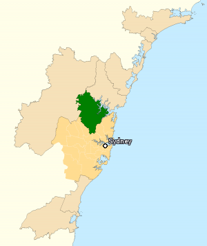
The Division of Berowra is an Australian electoral division in the state of New South Wales. The Division covers the northern parts of the Greater Sydney area with the local government areas of the Hornsby Shire and the Hills Shire.

<span class="mw-page-title-main">Asquith, New South Wales</span> Suburb of Sydney, New South Wales, Australia

Asquith is an outer suburb of Northern Sydney in the state of New South Wales, Australia. Asquith is located 26 km north-west of the Sydney central business district, in the local government area of Hornsby Shire. The suburb contains a section of Ku-ring-gai Chase National Park on its eastern side.

<span class="mw-page-title-main">Berowra railway station</span> Railway station in Sydney, New South Wales, Australia

Berowra railway station is located on the Main Northern Line, serving the Sydney suburb of Berowra. It is served by Sydney Trains T1 North Shore Line services and NSW TrainLink Central Coast & Newcastle Line services.

<span class="mw-page-title-main">Pennant Hills, New South Wales</span> Suburb of Sydney, New South Wales, Australia

Pennant Hills is a suburb in the Northern Sydney region of Sydney, New South Wales, Australia. Pennant Hills is located 18 kilometres north-west of the Sydney central business district in the local government area of Hornsby Shire.

Westleigh is a suburb in the Upper North Shore region of Sydney in the state of New South Wales, Australia, 22 kilometres north-west of the Sydney central business district in the local government area of Hornsby Shire.

<span class="mw-page-title-main">Brooklyn, New South Wales</span> Outer Suburb of Sydney, New South Wales, Australia

Brooklyn is a suburb and the northern most town on the Pacific Highway in Sydney, New South Wales, Australia. Brooklyn is located on the northern outskirts of Sydney and is located in the local government area of the Hornsby Shire with a population of 722 as of the 2016 census. Brooklyn is surrounded by the Muogamarra Nature Reserve and occupies a strip of waterfront along the southern bank of the Hawkesbury River.

<span class="mw-page-title-main">Berowra, New South Wales</span> Suburb of Sydney, New South Wales, Australia

Berowra is an outer suburb of Northern Sydney located in the state of New South Wales, Australia. It is located 36 kilometres north of the Sydney central business district, in the local government area of Hornsby Shire. Berowra is south-east of the suburbs of Berowra Heights and east of Berowra Waters. The name Berowra means place of many shells, referring to the many shell middens on Berowra Creek.

<span class="mw-page-title-main">Mount Colah</span> Suburb of Sydney, New South Wales, Australia

Mount Colah is an outer suburb of Northern Sydney, in the state of New South Wales, Australia 24 kilometres north of the Sydney central business district, in the local government area of Hornsby Shire.

<span class="mw-page-title-main">Mount Kuring-gai, New South Wales</span> Suburb of Sydney, New South Wales, Australia

Mount Kuring-gai is an outer suburb of Northern Sydney, in the state of New South Wales, Australia. Mount Kuring-gai is located 31 kilometres north-west of the Sydney central business district, in the local government area of Hornsby Shire.

<span class="mw-page-title-main">Berowra Waters, New South Wales</span> Suburb of Sydney, New South Wales, Australia

Berowra Waters is an outer suburb of Northern Sydney, in the state of New South Wales, Australia. Berowra is located 40 kilometres north of the Sydney central business district, in the local government area of Hornsby Shire. Berowra Waters is north-west of the suburbs of Berowra Heights and west of Berowra.

<span class="mw-page-title-main">Cowan, New South Wales</span> Outer Suburb near Sydney, New South Wales, Australia

Cowan is a small outer suburb of Sydney, in the state of New South Wales, Australia, approximately 40 kilometres (25 mi) north of the Sydney central business district, in the local government area of Hornsby Shire. Cowan shares the postcode of 2081 with Berowra. Brooklyn, which lies 6 kilometres (3.7 mi) to the north-east of Cowan, is considered the northernmost suburb of the Greater Sydney Metropolitan Area.

<span class="mw-page-title-main">Hornsby Heights, New South Wales</span> Suburb of Sydney, New South Wales, Australia

Hornsby Heights is a suburb of Northern Sydney, in the state of New South Wales, Australia. Hornsby Heights is located 26 kilometres north-west of the Sydney central business district, in the local government area of Hornsby Shire. The suburb is often referred to as part of the Upper North Shore.

<span class="mw-page-title-main">Berowra Creek</span> River in New South Wales, Australia

The Berowra Creek, a watercourse that is part of the Hawkesbury-Nepean catchment, is located to the north of the Sydney central business district in the Hornsby Shire of New South Wales, Australia.

<span class="mw-page-title-main">Mooney Mooney, New South Wales</span> Suburb of Central Coast, New South Wales, Australia

Mooney Mooney is a small waterfront village and suburb of the Central Coast region of New South Wales, Australia. It is located in the Central Coast Council local government area at the end of a peninsula extending southwards into the Hawkesbury River, that is situated 50 kilometres (31 mi) north of Sydney. Mooney Mooney has two islands which are Peat Island and Spectacle Island.

Yellow Rock is a small village or locality in the Blue Mountains region of New South Wales, Australia. At the 2011 census, Yellow Rock had a population of 1029.

<span class="mw-page-title-main">Northern Sydney</span> Region of Sydney in New South Wales, Australia

Northern Sydney is a large metropolitan area in Greater Sydney, New South Wales, Australia on the north shore of Sydney Harbour and Parramatta River. The region embraces suburbs in Sydney's north-east, north and inner north west. Northern Sydney is divided into distinctive regions such as the North Shore, Northern Beaches and Forest District.

<span class="mw-page-title-main">Berowra Waters Ferry</span>

The Berowra Waters Ferry is a cable ferry across the Berowra Creek, a tributary of the Hawkesbury River, located in the Berowra Valley National Park, Sydney, Australia. The ferry operates from the community of Berowra Waters on the west bank of the creek, to a landing on the east bank, thus connecting with the road to Berowra Heights.

<span class="mw-page-title-main">Berowra Valley National Park</span> Protected area in New South Wales, Australia

The Berowra Valley National Park is a protected national park that is located in northern Sydney, New South Wales, Australia. The 3,884-hectare (9,600-acre) national park is situated approximately 20 kilometres (12 mi) north-west of the Sydney central business district.

References

  1. Australian Bureau of Statistics (27 June 2017). "Berowra Heights (State Suburb)". 2016 Census QuickStats. Retrieved 12 April 2018. OOjs UI icon edit-ltr-progressive.svg
  2. Phoenix Auctions History. "Post Office List" . Retrieved 19 January 2021.
  3. https://schoolfinder.education.nsw.gov.au/
  4. "Berowra brigade celebrates new station and honours members". NSW Rural Fire Service . 11 August 2018. Archived from the original on 31 March 2019. Retrieved 31 March 2019.
  5. "Welcome to Berowra Rural Fire Brigade". NSW Rural Fire Service . Archived from the original on 31 March 2019. Retrieved 31 March 2019.

Notes

33°36′48″S151°08′17″E / 33.61334°S 151.13800°E / -33.61334; 151.13800