Thornleigh Sydney, New South Wales | |||||||||||||||
---|---|---|---|---|---|---|---|---|---|---|---|---|---|---|---|
Population | 8,898 (2021 census) [1] | ||||||||||||||
• Density | 2,220/km2 (5,800/sq mi) | ||||||||||||||
Established | 1830s | ||||||||||||||
Postcode(s) | 2120 | ||||||||||||||
Elevation | 170 m (558 ft) | ||||||||||||||
Area | 4 km2 (1.5 sq mi) | ||||||||||||||
Location | 22 km (14 mi) north-west of Sydney CBD | ||||||||||||||
LGA(s) | Hornsby Shire | ||||||||||||||
State electorate(s) | |||||||||||||||
Federal division(s) | Berowra | ||||||||||||||
|
Thornleigh is a suburb in the Upper North Shore region of Sydney in the state of New South Wales, Australia. Thornleigh is located 22 kilometres north-west of the Sydney central business district in the local government area of Hornsby Shire. The source of the Lane Cove River is located in Thornleigh.
Thornleigh is bounded to the north by Waitara Creek and south by the Lane Cove National Park. Thornleigh borders the suburbs of Normanhurst, Hornsby, Wahroonga, Westleigh and Pennant Hills. Thornleigh offers great district views, and the topography varies greatly with many established areas built around bushland settings and into the hills to afford the great views. The northern areas of the suburb bounded by Larool Creek and Waitara Creek are leafy and lush with vegetation and native fauna including rainbow lorikeets, kookaburras, cockatoos, and bush turkeys. Majorie Headen Lookout is a vantage point which overlooks Larool and Waitara Creek Valley. [2] The area bounded near the train station and the Comenarra Parkway include early examples of Federation and Californian Bungalow style properties.
Thornleigh was originally part of the land that the Kuringai people settled. The first non-indigenous people to explore the area of Thornleigh were a party led by Governor Arthur Phillip in 1788. Settlers moved into the area in the 1830s and among them were James Milson, Patrick Duffy, John Thorn and Samuel Horne. [3] Thornleigh is named after Constable John Thorn, who, along with Constable Horne, captured bushrangers Dalton and John MacNamara, leader of the North Rocks gang, on 22 June 1830, and were granted land as a reward in 1838. Horne's land became Hornsby (now Normanhurst), and Thorn's land became Thornleigh. [4]
Orcharding was one of the major mainstays of Thornleigh during the late nineteenth century. Land sales posters used this as an attraction for prospective settlers describing the area as "beautifully situated (and) surrounded by magnificent orchards, the fruit from which affords a splendid proof of the fertility of the soil and mildness of the climate". Among the orchard growers was Patrick Michael Duffy, after which Duffy Avenue was named. After Patrick Duffy's passing, his land was subdivided and passed down to his son Patrick Duffy Jnr. Eventually part of this land was purchased by the wealthy Friend family who built the Windyhaugh property on Duffy Avenue, which was later used as the first Presbyterian Fellowship Union camp in the Commonwealth. [5]
As part of the construction of the railway from Strathfield to Hornsby, a 1.2 km branch was constructed in 1884 by the contractors to a quarry in a gully west of Thornleigh. The tracks included a zig zag section. [6]
Thornleigh railway station opened on 17 September 1886 where the local produce (mainly citrus fruits) was exported to the city markets. Fruit grown at Thornleigh was also being exported as far as Vancouver and San Francisco. [3]
Thornleigh Post Office opened on 12 March 1888. [7]
The Thornleigh School of Arts opened in 1890 and was demolished in 1980 along with many other locations of historical significance in the suburb throughout the commercial development of the area in the 1970s and 1980s. These include the Astra Theatre (Originally named the Prince of Wales Theatre in 1923), the Royal Hotel, Thornleigh Public School with its World War I memorial and the original Edwardian structures at Thornleigh Railway Station. The Thornleigh Community Centre was constructed by the local and state government in order to compensate the community for the demolition of the Thornleigh School of Arts. [8]
In 1901, the National Brickworks started operations at Thornleigh. In 1913, the largest malt works in the southern hemisphere was established by WG Chilvers. [3] Chilvers Road was named after William George Chilvers. Other streets with notable names include Norman Avenue, named after the Australian engineer Norman Selfe.
During the Great Depression of the 1930s, unemployment was a problem in the area, so a local woman named Lorna Brandt raised money for the construction of a walking track near the Lane Cove River as a way of providing relief work. The track begins at Thornleigh Oval, at the bottom of Handley Avenue, and goes through the bush towards the Lane Cove River. It then goes parallel to the river for a short distance before looping back to arrive at Comenarra Parkway. An extension goes down to the river, through a spot called Conscript Pass. At this spot, there are rock carvings done by the men who worked on the track. One of the carvings is a caricature of Bertram Stevens, Premier of New South Wales from 1932 to 1939. [9] The track is known as Lorna Pass in memory of Lorna Brandt, and is now part of the Great North Walk, a long-distance walking trail between Sydney and Newcastle. [10]
Plans to establish a university at Thornleigh in response to the large number of enrolments at the University of Sydney and the University of New South Wales were discussed in the early 1960s due to Thornleigh being "Central to the Northern Line and the North Shore", however, the university was eventually established in the suburb of Macquarie Park and is now known as Macquarie University. [8]
Thornleigh railway station is on the Northern Line of the Sydney Trains network. Pennant Hills Road is part of the National Highway, and is one of Sydney's major thoroughfares. The Esplanade from Pennant Hills is a main road accessing Thornleigh to Normanhurst. The Comenarra Parkway is an arterial road that stretches from Thornleigh through to West Pymble via Wahroonga, Turramurra and South Turramurra.
Bus services from the CDC NSW Upper North Shore service include:
Thornleigh contains industrial and commercial areas.
Thornleigh Marketplace containing a supermarket and speciality stores was constructed in 2005 and includes: A post office, butchers, hair and nail salons, pharmacy, newsagency, gym, sushi bar, cafes, optometrist and Woolworths.
Shops and restaurants are located around Thornleigh railway station and nearby Pennant Hills. The household hardware chain Bunnings Warehouse have a store located next to Pennant Hills Road. American multinational fast food restaurant chain McDonald's have their Australian headquarters and flagship store in Thornleigh. [14]
Thornleigh Public and Infants Schools were demolished in the 1980s and a Bunnings hardware now sits in its place.
At the 2021 census, the population of Thornleigh in 2016 was 8,898 people. Of these: [1]
The local sports clubs include the Thornleigh Sport and Recreation Club with baseball, basketball, cricket, netball, soccer and softball divisions. [15] The soccer club known as Thunder FC consists of teams ranging from Under 6s through to All Age divisions playing in the Gladesville Hornsby Football Association. Home grounds are Oakleigh Oval and Ruddock Park. [16] The Brickpit Park is used for Basketball where it is home to the Hornsby-Ku-Ring-Gai Basketball Association. It is also a popular sports venue for public and private schools in the Hornsby-Kuring-gai area. Other venues at the Brickpit Park include The Thornleigh Golf Centre, which includes driving ranges and mini-golf courses. Skateboarding and other passive recreational activities are also available at the Brickpit. [17] Thornleigh Squash Centre has 9 glass backed courts.
Hornsby is a suburb on the Upper North Shore of Sydney in the state of New South Wales, Australia, approximately 23 kilometres (14 mi) north-west of the Sydney central business district. It is the administrative centre of the local government area of Hornsby Shire.
The North Shore is a region within Northern Sydney, in the state of New South Wales, Australia, generally referring to suburbs located on the northern side of Sydney Harbour up to Wahroonga, and suburbs between Middle Harbour and the Lane Cove River.
Wahroonga is a suburb in the Upper North Shore of Sydney, in the state of New South Wales, Australia, 18 kilometres north-west of the Sydney central business district, in the local government areas of Ku-ring-gai Council and Hornsby Shire. North Wahroonga is an adjacent separate suburb of the same postcode.
Hornsby Shire is a local government area situated in Northern Sydney, as well as parts of the Hills District, in the state of New South Wales, Australia. The shire stretches from the M2 Hills Motorway in the south to the Hawkesbury River town of Wisemans Ferry, some 53 kilometres (33 mi) to the north, making it the largest local government council in the Greater Sydney Metropolitan region by total area. As of the 2016 census the shire had an estimated population of 142,667.
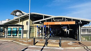
Hornsby railway station is located at the junction of the Main Northern and North Shore lines, serving the Sydney suburb of Hornsby. It is served by Sydney Trains T1 North Shore Line and T9 Northern Line services and NSW TrainLink Intercity and regional services.
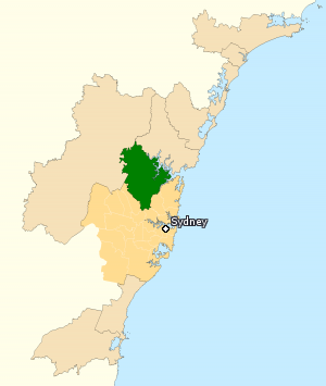
The Division of Berowra is an Australian electoral division in the state of New South Wales. The Division covers the northern parts of the Greater Sydney area with the local government areas of the Hornsby Shire and the Hills Shire.
Asquith is an outer suburb of Northern Sydney in the state of New South Wales, Australia. Asquith is located 26 km north-west of the Sydney central business district, in the local government area of Hornsby Shire. The suburb contains a section of Ku-ring-gai Chase National Park on its eastern side.
Westleigh is a suburb in the Upper North Shore region of Sydney in the state of New South Wales, Australia, 22 kilometres north-west of the Sydney central business district in the local government area of Hornsby Shire.
Cherrybrook is a suburb of Sydney, in the state of New South Wales, Australia 29 kilometres north-west of the Sydney central business district in the local government area of Hornsby Shire. Cherrybrook is often referred to as being located in the Hills District of Sydney.
Normanhurst is a suburb in the Upper North Shore region of Sydney in the state of New South Wales, Australia, 22 kilometres north-west of the Sydney central business district in the local government area of Hornsby Shire.
Thornleigh railway station is located on the Main Northern line, serving the Sydney suburb of Thornleigh. It is served by Sydney Trains T9 Northern Line services.
Pennant Hills railway station is located on the Main Northern line, serving the Sydney suburb of Pennant Hills. It is served by Sydney Trains T9 Northern Line services.
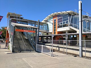
Rhodes railway station is a heritage-listed railway station located on the Main Northern line, serving the Sydney suburbs of Rhodes and Liberty Grove both in City of Canada Bay, Sydney, New South Wales, Australia. It is served by Sydney Trains T9 Northern Line services.
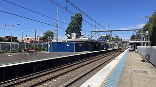
Normanhurst railway station is located on the Main Northern line, serving the Sydney suburb of Normanhurst. It is served by Sydney Trains T9 Northern Line services.
Waitara is a suburb in the Northern Sydney region of Sydney, in the state of New South Wales, Australia 19 kilometres north-west of the Sydney central business district, in the local government area of Hornsby Shire.
Pennant Hills Road is a 16.1-kilometre-long (10.0 mi) arterial road located in Sydney, New South Wales, Australia. The road links the suburb of Wahroonga in the northeast, to the major central business district of Parramatta in the southwest. Apart from a small section at its southwestern end, it is a constituent part of Cumberland Highway, and is designated part of route A28.
Northern Sydney is a large metropolitan area in Greater Sydney, New South Wales, Australia on the north shore of Sydney Harbour and Parramatta River. The region embraces suburbs in Sydney's north-east, north and inner north west. Northern Sydney is divided into distinctive regions such as the North Shore, Northern Beaches and Forest District.
The metropolis of Greater Sydney in New South Wales, Australia, is informally subdivided into a number of geographic regions. The geographical definition of Greater Sydney spans across 33 local government areas and includes the Blue Mountains in the west, the Northern Beaches and the Hawkesbury in the north, the Royal National Park, the Wollondilly and Macarthur in the south, and Botany Bay in the east. These areas sometimes, but not always, roughly coincide with official boundaries of suburbs, local government authorities, or cadastral units, and some of the customary regions do not have well defined boundaries at all. Some commonly referred to regions overlap: for example, Canterbury-Bankstown is often referred to as a region, but it is also part of the South Western Sydney region. The regions themselves are not used as a formal jurisdiction, and generally do not have administrative or legislative bodies, although some regions are coterminous with a local government area, and in a number of regions that include multiple local government areas, Regional Organisations of Councils have been established that represent the councils in the region.
Wahroonga is an electoral district of the Legislative Assembly in the Australian state of New South Wales. It was contested for the first time at the 2023 election.