Cherrybrook, New South Wales

Last updated

Cherrybrook
Sydney,  New South Wales
Cherrybrook, New South Wales
Population19,082 (2021 census) [1]
Postcode(s) 2126
Elevation185 m (607 ft)
Location30 km (19 mi) north-west of Sydney CBD
LGA(s) Hornsby Shire
State electorate(s) Epping
Federal division(s) Berowra
Suburbs around Cherrybrook:
Dural Dural Westleigh
Castle Hill Cherrybrook Westleigh
Castle Hill West Pennant Hills Pennant Hills

Cherrybrook is a suburb of Sydney, in the state of New South Wales, Australia 29 kilometres north-west of the Sydney central business district in the local government area of Hornsby Shire. Cherrybrook is often referred to as being located in the Hills District of Sydney.

Contents

History

European settlement

Joseph Harrison, who had married Mary Ann Thompson, settled on a block in the area in 1839, planted orchards and built a small timber cottage they called "Cherrybrook Cottage".[ citation needed ] The name "Cherrybrook" is believed to have come from the fact they grew cherry trees near the creek, which passed through their land. Their 65-acre (260,000 m2) block, which became known as "Cherrybrook Farm", had been granted originally to Mary Russell during the 1820s. The orchards here produced peaches, apricots, pears, plums, and citrus fruit. Many years later the property was bought by Eric Vaux, who established a dairy and kept the name Cherrybrook.[ citation needed ]

In February 1959, the land was subdivided to become the first project home village in Sydney. The original bushland was bulldozed, and exhibition homes were built on cut and fill sites, then landscaped. Accelerated development occurred again in the remaining rural areas in the 1980s, and Cherrybrook Post Office opened on 20 July 1994. [2]

Street names

Many of Cherrybrook's streets are named after native plants, trees, historical figures from convict times or local landowners. When Cherrybrook was subdivided from 1959 onwards, the developers chose colonial architects as a theme for naming some streets. None of the colonial architects and surveyors were associated with or lived in Cherrybrook. [3]

Transport

Cherrybrook railway station work site, August 2015 Sydney Metro Cherrybrook Station worksite, August 2015.jpg
Cherrybrook railway station work site, August 2015

Cherrybrook is serviced by CDC NSW bus routes linking to Sydney CBD and Cherrybrook railway station, which is on the Metro North West Line of the Sydney Metro network, which opened 26 May 2019.

Commercial areas

Cherrybrook Village Shopping Centre is a fully enclosed, single level neighbourhood shopping centre that has Woolworths as its major tenant. It opened in 1989 and was refurbished in 2004. [4] Appletree Shops is a smaller shopping centre.

Education

Cherrybrook is serviced by a number of educational institutions, including Cherrybrook Nursery and Preschool, ABC Developmental Learning Centre, Kindalin Early Childhood Learning Centre, Cherrybrook Community Pre-School, Cherrybrook Public School, John Purchase Public School, Cherrybrook Technology High School, Tangara School for Girls, and Inala, a Rudolf Steiner School supporting individuals with disabilities.

Cherrybrook Technology High School (CTHS) is currently the largest government secondary school in the state with over 2000 students and is growing larger each year, although it was originally built to accommodate 900 students.

Religion

The most popular responses in the 2021 census question about religion were No Religion, so described 31.9%, followed by Catholic 17.0%, Hinduism 11.1%, Anglican 9.9%, and Buddhism 5.1%. [1]

Cherrybrook has a large number of Christian churches of many denominations:

There is also a Buddhist Mahāyāna Monastery.

Sport and recreation

1st Cherrybrook Scout Group neckerchief 1st Cherrybrook Scout Group, New South Wales neckerchief.jpg
1st Cherrybrook Scout Group neckerchief

Recreation areas include Greenway Park (featuring Indoor Heated Swimming Pool and a fenced Dog Park), The Lakes of Cherrybrook, Edward Bennett Oval (Soccer, Cricket), Thomas Thompson Park (Tennis, Soccer, Cricket), and a number of other small parks. Cherrybrook also has a number of walking trails and fire trails that are part of the Berowra Bushland Reserve, including the Callicoma Walk. Cherrybrook has a large Baseball community with over 500 playing members who call Greenway park home for the Greenway Giants Baseball Club. [5]

Demographics

Historical population
YearPop.±%
200118,601    
200618,491−0.6%
201118,778+1.6%
201618,765−0.1%
202119,086+1.7%

According to the 2021 census there were 19,082 residents in Cherrybrook. Of these:

Notable residents

Related Research Articles

<span class="mw-page-title-main">Castle Hill, New South Wales</span> Suburb of Greater Western Sydney, New South Wales, Australia

Castle Hill is a suburb of Sydney, New South Wales, Australia, located 34 kilometres north-west of the Sydney central business district and 9.5 kilometres north of Parramatta. It is within the Hills District region, split between the local government areas of The Hills Shire and Hornsby Shire.

<span class="mw-page-title-main">Hornsby, New South Wales</span> Suburb of Sydney, New South Wales, Australia

Hornsby is a suburb on the Upper North Shore of Sydney in the state of New South Wales, Australia, approximately 23 kilometres (14 mi) north-west of the Sydney central business district. It is the administrative centre of the local government area of Hornsby Shire.

<span class="mw-page-title-main">Carlingford, New South Wales</span> Suburb of Sydney, New South Wales, Australia

Carlingford is a suburb of Sydney, in the state of New South Wales, Australia. Carlingford is 22 kilometres north-west of the Sydney central business district in the local government area of City of Parramatta. Carlingford sits at the meeting point of Northern Sydney and Western Sydney sitting on both sides of Pennant Hills Road which generally acts as a divider of the two regions. While being part of City of Parramatta, it is sometimes referred to as being part of the Hills District.

<span class="mw-page-title-main">Francis Greenway</span> Architect

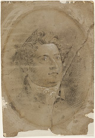
Francis Howard Greenway was an English-born architect who was transported to Australia as a convict for the crime of forgery. In New South Wales he worked for the Governor, Lachlan Macquarie, as Australia's first government architect. He became widely known and admired for his work displayed in buildings such as St Matthew's Church, St James' Church and Hyde Park Barracks.

Dural is a semi rural suburb of Sydney, in the state of New South Wales, Australia 36 kilometres north-west of the Sydney central business district in the local government areas of Hornsby Shire and The Hills Shire. Dural is part of the Hills District. Round Corner is a locality in the south-western part of Dural.

<span class="mw-page-title-main">Hornsby Shire</span> Local government area in New South Wales, Australia

Hornsby Shire is a local government area situated in Northern Sydney, as well as parts of the Hills District, in the state of New South Wales, Australia. The shire stretches from the M2 Hills Motorway in the south to the Hawkesbury River town of Wisemans Ferry, some 53 kilometres (33 mi) to the north, making it the largest local government council in the Greater Sydney Metropolitan region by total area. As of the 2016 census the shire had an estimated population of 142,667.

<span class="mw-page-title-main">North Epping, New South Wales</span> Suburb of Sydney, New South Wales, Australia

North Epping is a suburb of Sydney, in the state of New South Wales, Australia 19 kilometres north-west of the Sydney central business district in the local government area of Hornsby Shire. North Epping is in the Northern Sydney region, and is often referred to as part of the "North-West" or North Shore. Epping is a separate suburb to the south and under the Parramatta City Council, which shares the postcode of 2121.

<span class="mw-page-title-main">Division of Berowra</span> Australian federal electoral division

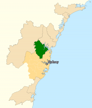
The Division of Berowra is an Australian electoral division in the state of New South Wales. The Division covers the northern parts of the Greater Sydney area with the local government areas of the Hornsby Shire and the Hills Shire.

<span class="mw-page-title-main">Pennant Hills, New South Wales</span> Suburb of Sydney, New South Wales, Australia

Pennant Hills is a suburb in the Northern Sydney region of Sydney, New South Wales, Australia. Pennant Hills is located 18 kilometres north-west of the Sydney central business district in the local government area of Hornsby Shire.

<span class="mw-page-title-main">Thornleigh, New South Wales</span> Suburb of Sydney, New South Wales, Australia

Thornleigh is a suburb in the Upper North Shore region of Sydney in the state of New South Wales, Australia. Thornleigh is located 22 kilometres north-west of the Sydney central business district in the local government area of Hornsby Shire. The source of the Lane Cove River is located in Thornleigh.

Westleigh is a suburb in the Upper North Shore region of Sydney in the state of New South Wales, Australia, 22 kilometres north-west of the Sydney central business district in the local government area of Hornsby Shire.

<span class="mw-page-title-main">Beecroft, New South Wales</span> Suburb of Sydney, New South Wales, Australia

Beecroft is a suburb in the Northern Sydney region of Sydney, in the state of New South Wales, Australia 22 kilometres north-west of the Sydney central business district in the local government areas of Hornsby Shire and City of Parramatta.

<span class="mw-page-title-main">Baulkham Hills, New South Wales</span> Suburb of The Hills, New South Wales, Australia

Baulkham Hills is a suburb in the Hills District of Greater Sydney, in the state of New South Wales, Australia. It is 30 kilometres north-west of the Sydney central business district within the local government area of The Hills Shire. Baulkham Hills is the administrative seat of The Hills Shire, an outer metropolitan shire within Greater Sydney. The suburb is also the most populous within the Hills Shire. It is known colloquially as "Baulko". Baulkham Hill's Norwest Business Park is home to several Fortune 500 companies, a number of shopping centres, high-rise buildings, and industrial and recreational spaces.

<span class="mw-page-title-main">Galston, New South Wales</span> Suburb of Sydney, New South Wales, Australia

Galston is a semi-rural town located in the Hornsby District of Sydney, in the state of New South Wales, Australia. Galston is located from the city at 36 kilometres north-west of the Sydney central business district, in the local government area of the Hornsby Shire. Galston is in the NSW state electoral district of Hornsby and Federal division of Berowra. Galston is situated 16 minutes away from the suburb of Hornsby.

Glenorie is a rural suburb of Sydney, in the state of New South Wales, Australia, 44 kilometres north-west of the Sydney central business district in the local government areas of The Hills Shire and Hornsby Shire. Glenorie is part of the Hills District.

Glenorie Bus Company was an Australian bus company in the Hills District of Sydney.

<span class="mw-page-title-main">Cherrybrook Technology High School</span> Public school in Cherrybrook, New South Wales, Australia

Cherrybrook Technology High School is a purpose-built government technology high school located in Cherrybrook, a suburb in Sydney, Australia. The school was built in the late 1980s to support the rapid growth of the north-west sector in Sydney. With the school's completion and opening in 1992 the sheer size and capabilities of the school have grown beyond expectations. In 2002, a new two storey building with administration facilities on the ground floor and 12 classrooms on the top level was opened, bringing the permanent housing of the school up to 1250 students. 2009 saw the student population rise to over 2,000 for the first time.

<span class="mw-page-title-main">Northern Sydney</span> Region of Sydney in New South Wales, Australia

Northern Sydney is a large metropolitan area in Greater Sydney, New South Wales, Australia on the north shore of Sydney Harbour and Parramatta River. The region embraces suburbs in Sydney's north-east, north and inner north west. Northern Sydney is divided into distinctive regions such as the North Shore, Northern Beaches and Forest District.

NorthConnex is a 9-kilometre (5.6 mi) twin-tube motorway tunnel in northern Sydney, New South Wales, Australia, signposted as the M11 Tunnel. It acts as a tunnel bypass of the congested Pennant Hills Road, extending or connecting the M1 Pacific Motorway to the M2 Hills Motorway. Owned by NorthWestern Roads (NWR) Group, it is one of the longest road tunnels in Australia, along with the WestConnex Tunnel. It is also the deepest road tunnel in Australia, with more than half of the tunnel 60 metres (200 ft) deep or more, and the deepest point is underneath the Sydney Metro Northwest, about 90 metres (300 ft) below ground.

References

  1. 1 2 3 Australian Bureau of Statistics (28 June 2022). "Cherrybrook". 2021 Census QuickStats. Retrieved 19 December 2023. OOjs UI icon edit-ltr-progressive.svg
  2. Phoenix History. "Post Office List" . Retrieved 27 January 2021.
  3. 1 2 Source: Patrick, Trevor G. 1994, Street Names of Pennant Hills and Surrounding Suburbs of Beecroft, Cheltenham, Cherrybrook, Thornleigh, Westleigh, and West Pennant Hills, Silicon Quill, Hornsby, p. 13.
  4. Paramor, Greg; Collishaw, Nicholas; Pitt, Tony (23 January 2004). "ASX Announcement JF Meridian Trust Announces $21.2 Million Retail Redevelopment At Cherrybrook Village In Sydney" (PDF) (Press release). James Fielding Group. Archived from the original on 22 July 2008. Retrieved 28 June 2008.
  5. Greenway Giants Baseball & Softball Club
  6. Ahmad, Zia (3 February 2022). "Kazi Ali recognised with Order of Australia". Australasian Muslim Times. Archived from the original on 19 December 2023. Retrieved 21 June 2023.

33°43′30″S151°02′58″E / 33.72510°S 151.04931°E / -33.72510; 151.04931