Beverly, Washington

Last updated

Beverly, Washington
Milwaukee Road Bridge, Beverly WA.jpg
USA Washington location map.svg
Red pog.svg
Beverly, Washington
Coordinates: 46°50′05″N119°55′49″W / 46.83472°N 119.93028°W / 46.83472; -119.93028
Country United States
State Washington
County Grant
Elevation
550 ft (170 m)
Time zone UTC-8 (Pacific (PST))
  Summer (DST) UTC-7 (PDT)
ZIP code
99321
Area code 509
GNIS feature ID2807177 [1]

Beverly, Washington, United States, is a small unincorporated community along the banks of the Columbia River in central Washington state. The community, which consists of a few hundred residents, is a few miles downriver from Wanapum Dam and is nestled at the base of Sentinel Gap, a water gap in the Saddle Mountains that predates the Columbia River. The population as of 2020 was 266. [2]

Contents

History

Beverly was named around 1905 by H.R. Williams, after Beverly, Massachusetts. [3]

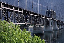
Beverly played host to hundreds of railroad workers from 1905-1920s when the Milwaukee Railroad was being built. The Milwaukee constructed a million-dollar bridge across the Columbia just north of Beverly, which was completed in 1909. Supplies to build the bridge were shipped via steamboat from points upstream, and were hauled in on other rail lines. The bridge took nearly two years to complete.

Beverly's early success depended partially on steep grades on the railroad, which meant helper locomotives were required to drive the trains. Colorful brochures were printed and distributed back east by companies touting Beverly's long growing season and sheltered location.

In 1977, the Milwaukee Road filed bankruptcy, and in the early 1980s Washington State removed the rail from east of Beverly to a junction near Royal City, although the hundred-year-old black iron bridge still stands today crossing the river.

During World War II and continuing up to the 1980s, thousands of rail cars moved through Beverly en route to the nearby Hanford facility. During that time the station in Beverly (now vacated) was remodeled and enhanced. Sometime in the late 1990s to early 2000s, the train station was demolished.

Beverly today

Beverly remains unincorporated, although it does have its own ZIP code. The old post office was burned down in 2003 due to arson, the only arson of a post office in the last 50 years in Washington State. Today, the community is served by a temporary post office building. The building was intended to serve Washington communities in the event of forest fires and other such calamities. The current mobile facility has been in place the last six years to serve the 99321 ZIP code.

Although residents have lobbied to keep their post office, residents in the nearby town of Mattawa have suggested that the post office combine the historical ZIP code with Mattawa's.

Climate

According to the Köppen Climate Classification system, Beverly has a semi-arid climate, abbreviated "BSk" on climate maps. [4]

See also

Related Research Articles

<span class="mw-page-title-main">Nenana, Alaska</span> City in Alaska, United States

Nenana (Lower Tanana: Toghotili; is a home rule city in the Yukon-Koyukuk Census Area of the Unorganized Borough in the Interior of the U.S. state of Alaska. Nenana developed as a Lower Tanana community at the confluence where the tributary Nenana River enters the Tanana. The population was 378 at the 2010 census, down from 402 in 2000.

<span class="mw-page-title-main">Potomac, Maryland</span> Census-designated place in Maryland, United States

Potomac is an unincorporated community and census-designated place in Montgomery County, Maryland, United States. As of the 2020 census, it had a population of 47,018. It is named after the nearby Potomac River. A part of the Washington metropolitan area, many Potomac residents work in nearby Washington, D.C., and Northern Virginia.

<span class="mw-page-title-main">Sagola Township, Michigan</span> Civil township in Michigan, United States

Sagola Township is a civil township of Dickinson County in the U.S. state of Michigan. The population was 1,066 at the 2020 census.

<span class="mw-page-title-main">Sterling, Virginia</span> Census-designated place in Virginia

Sterling, Virginia, refers most specifically to a census-designated place (CDP) in Loudoun County, Virginia, United States. The population of the CDP as of the 2020 United States Census was 30,337 The CDP boundaries are confined to a relatively small area between Virginia State Route 28 on the west and Virginia State Route 7 on the northeast, excluding areas near SR 606 and the Dulles Town Center.

<span class="mw-page-title-main">Sherman, Michigan</span> Unincorporated community in Michigan, United States

Sherman is an unincorporated community in Wexford County in the U.S. state of Michigan.

<span class="mw-page-title-main">Millersville, Maryland</span> Unincorporated community in Maryland, United States

Millersville is an unincorporated community in Anne Arundel County, Maryland, United States. Population was 20,965 in 2015 based on American Community Survey data.

<span class="mw-page-title-main">Bluemont, Virginia</span> Unincorporated community in Virginia, United States

Bluemont is an unincorporated village in Loudoun County, Virginia located at the eastern base of Snickers Gap in the Blue Ridge Mountains. The village's center is located along Snickersville Turnpike, 4 miles (6.4 km) west of the incorporated town of Round Hill. The village borders Virginia's fox hunting country and is within 1 mile (1.6 km) of the Appalachian Trail and the Bears Den and Raven Rocks formations in the Blue Ridge.

<span class="mw-page-title-main">Layton, New Jersey</span> Populated place in Sussex County, New Jersey, US

Layton is an unincorporated community and census-designated place (CDP) located within Sandyston Township in Sussex County, in the U.S. state of New Jersey. The area is served as United States Postal Service ZIP Code 07851.

Mumford is an unincorporated community in Robertson County, Texas, United States. It is part of the Bryan-College Station metropolitan area. Its elevation is 259 feet (79 m), and it is located at 30°44′4″N96°33′54″W. Mumford is unincorporated and has no post office, with the ZIP code of 77867; the ZCTA for ZIP Code 77867 had a population of 176 at the 2000 census.

<span class="mw-page-title-main">Bond, Colorado</span> Unincorporated community in State of Colorado, United States

Bond is an unincorporated community and U.S. Post Office in Eagle County, Colorado, United States. The Bond Post Office has the ZIP Code 80423. Although Bond has never had a sizable population, the town has significant railroad history, and once was a stop for most of the passenger trains along the Denver and Rio Grande Western's main line.

<span class="mw-page-title-main">Whipple, Ohio</span> Unincorporated community in Ohio, U.S.

Whipple is an unincorporated community in southern Salem Township, Washington County, Ohio, United States. Although it is unincorporated, it once had a post office, with the ZIP code 45788. It lies on State Route 821 south of the village of Lower Salem, at the junction of Whipple Run with Duck Creek. The community took its name from nearby Whipple Run.

<span class="mw-page-title-main">Clairfield, Tennessee</span> Unincorporated community in Tennessee, United States

Clairfield is an unincorporated community in Claiborne County, Tennessee, United States. It is located in the upper Clearfork Valley in the Cumberland Mountains of northeastern Tennessee. It is the site of a post office, assigned ZIP code 37715. The population of the Zip Code Tabulation Area corresponding to Clairfield's ZIP code was 1,002 as of the 2000 Census.

<span class="mw-page-title-main">Elmira, Michigan</span> Unincorporated community in Michigan, United States

Elmira is an unincorporated community in the U.S. state of Michigan. Located along M-32, the community is on the county line between Warner Township in Antrim County to the west and Elmira Township in Otsego County to the east.

<span class="mw-page-title-main">Washington State Route 243</span> State highway in Grant County, Washington

State Route 243 (SR 243) is a state highway in Grant County, Washington. It travels north–south along the Columbia River for 28 miles (45 km), connecting SR 24 at the Vernita Bridge to SR 26 near Vantage. The highway travels through a predominantly rural and desert area, serving two hydroelectric dams and the communities of Desert Aire, Mattawa, and Beverly.

<span class="mw-page-title-main">McNeil, Travis County, Texas</span> Unincorporated community in Texas, United States

McNeil is an unincorporated community in Travis County, Texas, United States. According to the Handbook of Texas, the community had a population of 70 in 2000. It is located within the Greater Austin Metropolitan area. Its elevation is 830 feet (253 m).

<span class="mw-page-title-main">Briggs, Texas</span> Census-designated place in Burnet County, Texas, United States

Briggs is an census-designated place (CDP) in eastern Burnet County, Texas, United States.

Glen Flora is an unincorporated community in Wharton County, Texas, United States. According to the Handbook of Texas, the community had an estimated population of 210 in 2000. It is located within the Greater Houston metropolitan area.

Dryden is a small unincorporated community in Chelan County, Washington, United States. It is situated along the Wenatchee River in the fertile Wenatchee Valley between the towns of Cashmere and Leavenworth. The community serves as a supply and shipping point for local farms and orchards.

<span class="mw-page-title-main">Monitor, Washington</span> Unincorporated community in Washington, United States

Monitor is a small unincorporated community in Chelan County, Washington, United States. It is situated along the Wenatchee River about 8 miles upstream from its junction with the Columbia River in the fertile Wenatchee Valley.

Jodie, also known as Imboden, is an unincorporated community in Fayette County, West Virginia, United States. It is located along the Gauley River at the mouth of Rich Creek, 4 miles (6.4 km) northeast of Gauley Bridge. Due to its proximity to the county line, Jodie is part of the Nicholas County ZIP code of 26690; it had its own post office until its closure on July 23, 2005.

References

  1. U.S. Geological Survey Geographic Names Information System: Beverly, Washington
  2. "Census Bureau profile: Beverly, Washington". United States Census Bureau. May 2023. Retrieved May 9, 2024.
  3. Majors, Harry M. (1975). Exploring Washington. Van Winkle Publishing Co. p. 134. ISBN   978-0-918664-00-6.
  4. Climate Summary for Beverly, Washington