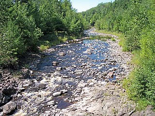
The Bad River is a river flowing to Lake Superior in northern Wisconsin in the United States. It flows for 119.6 kilometres (74.3 mi) in Ashland County, draining an area of 1,061 square miles (2,750 km2) in portions of Ashland, Bayfield and Iron counties. The Bad River sloughs were designated a Ramsar Wetland of International Importance on February 2, 2012.

The North Shore of Lake Superior runs from Duluth, Minnesota, United States, at the western end of the lake, to Thunder Bay and Nipigon, Ontario, Canada, in the north, to Sault Ste. Marie, Ontario in the east. The shore is characterized by alternating rocky cliffs and cobblestone beaches, with forested hills and ridges through which scenic rivers and waterfalls descend as they flow to Lake Superior.

Banning State Park is a state park of Minnesota, USA, stretched along 10 miles (16 km) of the Kettle River near Sandstone in Pine County. The centerpiece of the park is 1.5 miles (2.4 km) of churning rapids, some up to Class IV. The daring kayakers and canoeists who shoot Blueberry Slide, Mother's Delight, Dragon's Tooth, Little Banning, and Hell's Gate each spring attract spectators to the park. Landbound visitors can hike along the state's first Wild and Scenic River amid dramatic sandstone rock formations, large potholes carved by the river, and the remains of an historic quarry. Other features are Wolf Creek Falls and Robinson Ice Cave. The park is located directly off Interstate 35. Banning State Park is open daily from 8am until 10pm. Each vehicle entering the park requires an up to date permit which can be purchased online or at the park office.

Judge C. R. Magney State Park is a state park in the U.S. state of Minnesota, on the North Shore of Lake Superior. It was named for Clarence R. Magney, a former mayor of Duluth and justice of the Minnesota Supreme Court, who was instrumental in getting 11 state parks and scenic waysides established along the North Shore. The park is best known for the Devil's Kettle, an unusual waterfall and rock formation in which half of the Brule River disappears into a pothole.

Ohiopyle State Park is a Pennsylvania state park on 20,500 acres (8,300 ha) in Dunbar, Henry Clay and Stewart Townships, Fayette County, Pennsylvania in the United States. The focal point of the park is the more than 14 miles (23 km) of the Youghiogheny River Gorge that passes through the park. The river provides some of the best whitewater boating in the Eastern United States. Ohiopyle State Park is bisected by Pennsylvania Route 381 south of the Pennsylvania Turnpike. The park opened to the public in 1965 but was not officially dedicated until 1971.

The Ottawa National Forest is a national forest that covers 993,010 acres (401,860 ha) in the Upper Peninsula of the U.S. state of Michigan. It includes much of Gogebic and Ontonagon counties, as well as slices of Iron, Houghton, Baraga, and Marquette counties. The forest is under the jurisdiction of the U.S. Forest Service.

Wadsworth Falls State Park, or simply Wadsworth Falls, is a public recreation and preserved natural area located on the Coginchaug River in the towns of Middletown and Middlefield, Connecticut. The state park's 285 acres (115 ha) offer trail hiking and fishing. Swimming and picnicking are allowed at the pond near the north entrance near 721 Wadsworth Street in Middletown. It is managed by the Connecticut Department of Energy and Environmental Protection.

South Cumberland State Park is a state park in the middle and southeast portions of Tennessee on the Cumberland Plateau.

Amnicon Falls State Park is a state park of Wisconsin, United States. The 828-acre (335 ha) park is located in South Range, Wisconsin, southeast of the city of Superior. It features a series of waterfalls on the Amnicon River as it flows around a small island and under a historic covered bridge.
Foxboro is an unincorporated community, in Douglas County, in the town of Summit, in the northwestern part of the U.S. state of Wisconsin.

Ozone Falls State Natural Area is a state natural area in Cumberland County, Tennessee in the southeastern United States. It consists of 43 acres (0.17 km2) centered on Ozone Falls, a 110-foot (34 m) plunge waterfall, and its immediate gorge along Fall Creek. Because of its picturesque beauty and easy access, Disney selected Ozone Falls for scenes for their live-action film "Rudyard Kipling's The Jungle Book". The area is managed by the Tennessee Department of Environment and Conservation and maintained by Cumberland Mountain State Park. It is also part of Cumberland Trail State Park.

The Gogebic Range is an elongated area of iron ore deposits located within a range of hills in northern Michigan and Wisconsin just south of Lake Superior. It extends from Lake Namakagon in Wisconsin eastward to Lake Gogebic in Michigan, or almost 80 miles. Though long, it is only about a half mile wide and forms a crescent concave to the southeast. The Gogebic Range includes the communities of Ironwood in Michigan, plus Mellen and Hurley in Wisconsin.

Pocket wilderness is a name used by Bowater corporation and the State of Tennessee for any of several tracts of Bowater-owned private land on and near the Cumberland Plateau that the company set aside beginning in 1970 "for preservation in its natural state, with no logging or development other than hiking trails permitted within its boundaries" and registered as Tennessee state natural areas. Several areas formerly managed as Bowater pocket wilderness are now incorporated into state-owned natural areas or National Park Service sites.

Copper Falls State Park is a 3,068-acre (1,242 ha) state park in Wisconsin. The park contains a section of the Bad River and its tributary the Tylers Forks, which flow through a gorge and drop over several waterfalls. Old Copper Culture Indians and later European settlers mined copper in the area. The state park was created in 1929 and amenities were developed by the Civilian Conservation Corps and the Works Progress Administration. In 2005 the park was listed on the National Register of Historic Places as a site with 10 contributing properties.

Pattison State Park is a 1,436-acre (581 ha) Wisconsin state park south of Superior, Wisconsin. Situated on the Black River, the park contains both Big Manitou Falls, the highest waterfall in Wisconsin at 165 feet (50 m), and Little Manitou Falls, which is 30 feet (9.1 m). Pattison State Park was established in 1920.
Menominee River State Recreation Area is a state-managed protected area located in Breitung and Norway townships in Dickinson County and Faithorn Township in Menominee County, Michigan, southeast of Iron Mountain. It is 2,354 acres (953 ha) in area and is currently undeveloped. The park comprises a 145.35-acre (58.82 ha) tract along 1.5 miles (2.4 km) of the Menominee River south of the City of Norway and the 2,208.83-acre (893.88 ha) Quiver Falls Tract along eight miles (13 km) of the river farther downstream. In 2016, an additional 525-acre (212 ha) of Escanaba State Forest land was transferred from the Forestry Division to the DNR's Parks and Recreation Division and became the Pemene Falls Unit of the park, matching a similarly-named unit on the Wisconsin side of the river.
Menominee River State Park and Recreation Area is a state park unit of Wisconsin, United States, in development along the Menominee River. It was created in 2010 in conjunction with the Menominee River State Recreation Area on the Michigan side of the border river. The Wisconsin park is located in the towns of Niagara, Pembine, and Beecher in Marinette County in northeast Wisconsin. The 6,563-acre (2,656 ha) park comprises an undeveloped northern unit and a southern portion with primitive hiking trails and canoe/walk-in campsites.

The Amnicon River is a 45.5-mile (73.2 km) river in Douglas County, Wisconsin. The river's source is east of Dowling Lake and Amnicon Lake in central Douglas County, and its mouth is at Lake Superior east of Superior.

