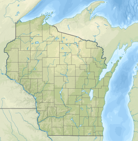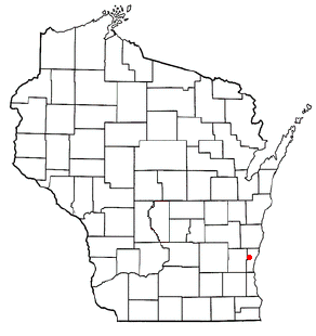
Saukville is a town in Ozaukee County, Wisconsin, United States. The Village of Saukville is located in the town's southeast quadrant. The population was 1,755 at the 2000 census.

Mer Bleue Bog is a 33.43 km2 (12.91 sq mi) protected area east of Ottawa in Eastern Ontario, Canada. Its main feature is a sphagnum bog that is situated in an ancient channel of the Ottawa River and is a remarkable boreal-like ecosystem normally not found this far south. Stunted black spruce, tamarack, bog rosemary, blueberry, and cottongrass are some of the unusual species that have adapted to the acidic waters of the bog.

The Laurentian Mixed Forest Province, also known as the North Woods, is a forested ecoregion in eastern North America. Among others, this terminology has been adopted by the Minnesota Department of Natural Resources. Similar, though not necessarily entirely identical regions, are identified by the United States Environmental Protection Agency as Northern Lakes and Forests, and by the World Wildlife Fund by regions such as the Western Great Lakes forests and Eastern forest-boreal transition.

Cranberry Glades — also known simply as The Glades — are a cluster of five small, boreal-type bogs in southwestern Pocahontas County, West Virginia, United States. This area, high in the Allegheny Mountains at about 3,400 feet (1,000 m), is protected as the Cranberry Glades Botanical Area, part of the Monongahela National Forest. This site is the headwaters of the Cranberry River, a popular trout stream, and is adjacent to the nearly 50,000-acre (200 km2) Cranberry Wilderness.
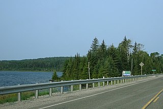
White Lake Provincial Park is a park in the Thunder Bay District of Northern Ontario, Canada, along Highway 17, north of Lake Superior.
The Tannersville Cranberry Bog or Cranberry Swamp is a sphagnum bog on the Cranberry Creek in Tannersville, Pennsylvania. It is the southernmost boreal bog east of the Mississippi River, containing many black spruce and tamarack trees at the southern limit of their ranges. Technically, it can be classed as an acid fen, as it receives some groundwater flow. The site was designated a National Natural Landmark in December 1974. It was purchased by The Nature Conservancy and the Conservation and Research Foundation in 1957. Like many bogs, its terrain presents an image of solidity, but a liquid mass of decaying peat lies beneath a six-inch (152 mm) layer of sphagnum and a network of supporting tree roots. However, this bog may be viewed from a floating walkway.

The New England-Acadian forests are a temperate broadleaf and mixed forest ecoregion in North America that includes a variety of habitats on the hills, mountains and plateaus of New England and New York State in the Northeastern United States, and Quebec and the Maritime Provinces of Eastern Canada.

The Au Sable State Forest is a state forest in the north-central Lower Peninsula of Michigan. It is operated by the Michigan Department of Natural Resources.

Minesing Wetlands, previously known as Minesing Swamp, is a Ramsar boreal wetland in central Ontario, Canada stretching from the western periphery of Barrie to Georgian Bay. It was identified and classified through the International Biological Program. It is "the largest and best example of fen bog in southern Ontario", one of the "most diverse undisturbed wetland tracts in Canada" and is a provincially significant Area of Natural and Scientific Interest. The term minesing is of Ojibwe origin and means "island", referring to an island located within Lake Edenvale, which encompassed the present-day wetlands and surrounding areas.

Coniferous swamps are forested wetlands in which the dominant trees are lowland conifers such as northern white cedar. The soil in these swamp areas is typically saturated for most of the growing season and is occasionally inundated by seasonal storms or by winter snow melt.
The Crow Wing State Forest is a state forest located near Fairfield Township in Crow Wing County, Minnesota. It is about 20 miles (32 km) northeast of the tourism-based town of Brainerd. Approximately 14,072 acres (5,695 ha) (44%) of the forest of 31,307 acres (12,669 ha) is actively managed. The managed acres are split nearly equally between the Minnesota Department of Natural Resources, Crow Wing County, and the privately owned Potlatch Corp.

Bayshore Blufflands State Natural Area is a Wisconsin Department of Natural Resources-designated State Natural Area of significant note for its grand scenery, unusual geology, rare plant and animal species. Containing more than 7 miles (11 km) of the Niagara Escarpment, the Bayshore Blufflands is an ecologically complex site with a diversity of plant communities both above and below the escarpment and a series of seeps and springs at the base of the bluff's talus slopes.

A bayhead or baygall is a specific type of wetland or swamp habitat. The name baygall is derived from sweetbay magnolia and sweet gallberry holly. Baygalls are recognized as a discrete ecosystem by ecologists and the swamps have been described as "distinct wetland communities in the Natural Communities of Louisiana". Baygall swamps are most often found in the low lying margins of floodplains and bottomlands with little or poor drainage to the main creek, bayou, or river channel. Baygall or bayhead swamps found on slopes and hillsides are sometimes referred to as a forest seep or hanging bogs. Hanging bogs are typically found in hardwood-pine forests. Most baygall swamps are semi-permanently saturated, or flooded.
Dorothy Lake State Natural Area is a Wisconsin Department of Natural Resources-designated State Natural Area featuring forested end moraine topography, with many steep-sided ridges and depressions. This results in a diverse mosaic of natural communities, including forests, swamps, fens, lakes, and streams.

Grandma Lake Wetlands State Natural Area is a Wisconsin Department of Natural Resources-designated State Natural Area featuring the undeveloped, pristine 44-acre Grandma Lake, which lies in a depression formed during the last glacial period. The lake is ringed by a large, open sphagnum bog mat. The bog mat is surrounded by a coniferous swamp of tamarack and black spruce. The bog mat supports a plant community that is considered diverse and unusual, with several rare species present, including: bog arrow-grass, dragon's mouth orchid, livid sedge, small-headed bog sedge, as well as one of only a few known populations of bog rush in the State of Wisconsin. In 1991, the US Forest Service designated the site as a Research Natural Area. Also, the site is listed as one of Wisconsin's Wetland Gems, by the Wisconsin Wetlands Association.

Brule Glacial Spillway is a Wisconsin Department of Natural Resources-designated State Natural Area that encompasses the valley of the upper reaches of the Bois Brule River. This valley was carved by the outlet of Glacial Lake Duluth, which occupied what is now the western portion of Lake Superior, during the retreat of the Superior lobe of Wisconsin glaciation. This outlet flowed southwestward through the valley, to what is now the St. Croix River. As the glacier melted, and the level of Lake Superior dropped, the direction of flow shifted to its present northeastward course, towards Lake Superior. A high point in a vast bog near Solon Springs marks the Saint Lawrence River Divide between the watersheds of the Gulf of Mexico and the Atlantic Ocean. This divide was used for thousands of years, by Native Americans, European explorers, fur traders, and settlers as a portage between the two watersheds.
Chippewa Moraine Lakes is a Wisconsin Department of Natural Resources-designated State Natural Area that comprises nine separate sites, spread out over roughly 30 square miles (78 km2). Each site features a primarily undisturbed lake located within the rough terminal moraine topography of northern Chippewa County. Each lake has its own unique species assemblage due to physical and chemical characteristics of the lake. The nine lakes are: Camp Lake, a 6-acre lake ringed by a floating sphagnum bog mat containing such plant species as white beak rush, narrow-leaved sundew, small cranberry, and grass pink orchid. Spence Lake, a 12-acre, acidic bog lake that is the headwaters of Foster Creek. Conifer swamp surrounds the northern part of the lake, hardwood swamp surrounds the central part, while the southern part is largely a sedge meadow, impacted by beaver activity. Bass Lake #1, a 6-acre soft-water seepage lake, with at least one rare plant species present. Bass Lake #5, an 8-acre, deep, hard-water seepage lake that is the main headwaters branch of Mud Creek. Deer Lake, a 6-acre seepage lake that is also part of the headwaters of Mud Creek. Burnt Wagon Lake, a 15-acre softwater seepage lake that is landlocked, with no development. Fishpole Lake, an 11-acre meromictic lake. Due to its size, shape, and depth, the lake's water column is permanently thermally stratified, unlike most Wisconsin lakes, leading to unique chemical and biological characteristics. Plummer Lake, a 41-acre, deep, hard-water seepage lake. Little Plummer Lake, a 10-acre wild hardwater seepage lake that drains into Plummer Lake.
Tamarack Swamp is a boreal (non-glacial) bog in Sproul State Forest, in Clinton County, Pennsylvania, in the United States. It is named for the tamarack tree, which inhabits the wetland. Numerous other species of plants and animals also inhabit the wetland. The total area of the wetland is 4000 acres. The Tamarack Swamp Natural Area is located in the wetland.
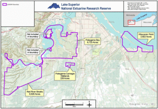
The Lake Superior National Estuarine Research Reserve includes land and water areas along the St. Louis River and Lake Superior in Douglas County, in the northwest corner of Wisconsin, United States. It is one of 29 National Estuarine Research Reserves. The Reserve is operated as a program of the Natural Resources Institute of the University of Wisconsin-Madison Division of Extension. It has an area of 16,697 acres (6,757 ha), and was designated in 2010.

Platanthera dilatata, known as tall white bog orchid, bog candle, or boreal bog orchid is a species of orchid, a flowering plant in the family Orchidaceae, native to North America. It was first formally described in 1813 by Frederick Traugott Pursh as Orchis dilatata.
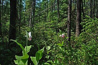 Showy ladyslippers photographed at Rice Creek State Natural Area
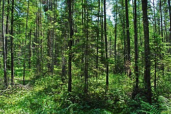 Conifer swamp at Rice Creek
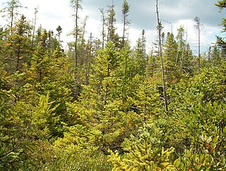
 Boreal rich fen located in the natural area
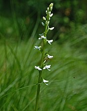 Platanthera dilatata photographed in the boreal rich fen