
A petroglyph is an image created by removing part of a rock surface by incising, picking, carving, or abrading, as a form of rock art. Outside North America, scholars often use terms such as "carving", "engraving", or other descriptions of the technique to refer to such images. Petroglyphs, estimated to be 20,000 years old are classified as protected monuments and have been added to the tentative list of UNESCO's World Heritage Sites. Petroglyphs are found worldwide, and are often associated with prehistoric peoples. The word comes from the Greek prefix petro-, from πέτρα petra meaning "stone", and γλύφω glýphō meaning "carve", and was originally coined in French as pétroglyphe.

The Jeffers Petroglyphs site is an outcrop in southwestern Minnesota with pre-contact Native American petroglyphs. The petroglyphs are pecked into rock of the Red Rock Ridge, a 23-mile (37 km)-long Sioux quartzite outcrop that extends from Watonwan County, Minnesota to Brown County, Minnesota. The exposed surface is approximately 150 by 650 feet and surrounded by virgin prairie. "The site lies in an area inhabited in the early historic period by the Dakota Indians, and both the style and form of some of the carvings are identical with motifs that appear on Dakota hide paintings and their quill designs and beadwork. Others are foreign to this Plains Indian tradition and seem to be much earlier in origin." Several old wagon trail ruts traverse the site, one of which is believed to be the old stage coach route from New Ulm, Minnesota to Sioux Falls, South Dakota.

Indian Grinding Rock State Historic Park is a California State Park, preserving an outcropping of marbleized limestone with some 1,185 mortar holes—the largest collection of bedrock mortars in North America. It is located in the Sierra Nevada foothills, 8 miles (13 km) east of Jackson. The park is nestled in a little valley 2,400 feet (732 m) above sea level, with open meadows and large specimens of valley oak that once provided the Miwok peoples of this area with an ample supply of acorns. The 135-acre (55 ha) park was established in 1962 and listed on the National Register of Historic Places in 1971.

Washington State Park is a public recreation area covering 2,147 acres (869 ha) in Washington County in the central eastern part of the state of Missouri. It is located on Highway 21 about 14 miles (23 km) northeast of Potosi or 7 miles (11 km) southwest of De Soto on the eastern edge of the Ozarks. The state park is noted for its Native American rock carvings and for its finely crafted stonework from the 1930s.
The Leo Petroglyph is a sandstone petroglyph containing 37 images of humans and other animals as well as footprints of each. The petroglyph is located near the small village of Leo, Ohio and is thought to have been created by the Fort Ancient peoples. The area in which the sandstone petroglyph was found is on the edge of an unglaciated Mississippian sandstone cliff 20–65 feet (6.1–19.8 m) high. A 20 by 16 feet slab containing the 37 carvings is protected by a wooden shelter, a Works Progress Administration project. The meanings of the drawings are unknown. On November 10, 1970, it was added to the National Register of Historic Places. The site is maintained by the Ohio History Connection.

The Red Bird River Petroglyphs, also known as the Red Bird Petroglyphs are a series of petroglyphs, or carvings, on a stone in Clay County, Kentucky. The rock originally was situated along the Red Bird River but was moved to a park in Manchester after it fell onto the roadway below in 1994.

Coso Rock Art District is a rock art site containing over 100,000 Petroglyphs by Paleo-Indians and/or Native Americans. The district is located near the towns of China Lake and Ridgecrest, California. Big and Little Petroglyph Canyons were declared a National Historic Landmark in 1964. In 2001, they were incorporated into this larger National Historic Landmark District. There are several other distinct canyons in the Coso Rock Art District besides the Big and Little Petroglyph Canyons. Also known as Little Petroglyph Canyon and Sand Tanks, Renegade Canyon is but one of several major canyons in the Coso Range, each hosting thousands of petroglyphs. The majority of the Coso Range images fall into one of six categories: bighorn sheep, entopic images, anthropomorphic or human-like figures, other animals, weapons & tools, and "medicine bag" images. Scholars have proposed a few potential interpretations of this rock art. The most prevalent of these interpretations is that they could have been used for rituals associated with hunting.

This is a list of the National Register of Historic Places listings in Pueblo County, Colorado, USA.

The Barnesville Petroglyph petroglyph site in the eastern part of the U.S. state of Ohio. Located approximately 3 miles (4.8 km) southwest of the village of Barnesville in Belmont County, the petroglyphs have been known both by archaeologists and the general public since the 1850s or earlier. Although the site was significantly damaged during the twentieth century, it is still a significant archaeological site, and has been named a historic site.

Indian God Rock is a large boulder in the northwestern part of the U.S. state of Pennsylvania. Located near the unincorporated community of Brandon, it lies along the Allegheny River in Venango County's Rockland Township. It is significant for the large petroglyph on one of its sides. Because of the petroglyph, the rock has been an explorers' landmark, a tourist attraction, and an object of scholarly investigation.

The Francis Farm Petroglyphs are a group of petroglyphs in the southwestern part of the U.S. state of Pennsylvania. Located on a boulder in Jefferson Township in the northwestern portion of Fayette County, it has been known to archaeologists since at least the middle of the nineteenth century. Despite damage in the 1930s, it remains an important archaeological site, and accordingly, it has been designated a historic site.

The Sugar Grove Petroglyphs are a group of petroglyphs in the southwestern part of the U.S. state of Pennsylvania. Located on an outcrop of sandstone in Monongahela Township near the eastern edge of Greene County, the petroglyphs have been known since at least the 1930s. Due to their value as an archaeological site, the petroglyphs have been named a historic site.
Hamilton Farm Petroglyphs, also known as Pictured Rocks and Indian Picture Rocks, are a series of ancient petroglyphs located on U.S. Route 119 southeast of Ringgold, in Monongalia County of northern West Virginia. The rock art designs were carved by early Native Americans on sandstone.
The Wildcat Branch Petroglyphs are five prehistoric petroglyph carvings located near Fort Gay, West Virginia. They were listed on the National Register of Historic Places in 1979. The petroglyphs are carved on a large rock in the backyard of a private home and are within 100 feet (30 m) of a creek. Four of the carvings depict birds, while the fifth appears to depict a beaver. The carvings were likely made during the Late Woodland period.
Petroglyph Canyon (24CB601) is an archaeologically significant canyon in the northwestern United States. Located on both sides of the border between Montana and Wyoming, the canyon has long been obscure due to its small size. However, it gained substantial attention in the late 20th century because of its numerous prehistoric petroglyphs, and much of it was named a historic site in the 1970s.

The Picture Rock Pass Petroglyphs Site is in northern Lake County, Oregon, United States. The site is located near the summit of Picture Rock Pass on land administered by the Bureau of Land Management. The designs were scraped into a basalt boulder by ancient Native Americans, probably between 7,500 and 12,000 years ago. No one knows the meaning of the petroglyph designs. Because of its unique archaeological and cultural significance, the Picture Rock Pass Petroglyph Site was listed on the National Register of Historic Places in 1975.

The Bellows Falls Petroglyph Site is an archaeological site containing panels of precontact Native American petroglyphs in Bellows Falls, Vermont. Located near the Vilas Bridge on bedrock west of and above the Connecticut River, adjacent to Great Falls, they depict a rarely-seen assemblage of anthropomorphic figures that is believed to be unique in New England, and uncommon even in surrounding geographic areas. The site was listed on the National Register of Historic Places in 1990.

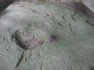
Inscription Rock is a large slab of limestone measuring approximately 32 by 21 feet located on the south shore of Kelleys Island in Lake Erie in Erie County, Ohio. It is situated near the intersections of E Lakeshore Drive and Addison Rd under a large shelter structure with a viewing platform and is open to the public. The rock was listed on the National Register of Historic Places in 1973 and was also located near a series of crescent shaped mounds thought to be created by Pre-Columbian peoples. More mounds were documented to be on the island and another rock with inscriptions was located on the north shore of the island. Unlike Inscription Rock, this boulder was granite - likely a glacial erratic - and engraved with two upside-down figures. However now only Inscription Rock remains since island quarry workers dynamited the petroglyph rock on the north shore.

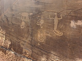
The Tolar Petroglyph Site is an archeological site in Sweetwater County, Wyoming. The site includes a sandstone rock formation with 32 panels of petroglyphs running for 150 feet (46 m) along the rock face. Many of the illustrations are of horse-mounted people of the Plains Indians in historical times. Other motifs include the turtle motif, spirit bear and shield-carrying warriors.


