
Denton is a village and civil parish in the South Kesteven district of Lincolnshire, England. The population of the civil parish was 273 at the 2011 census. It is situated approximately 3 miles (5 km) both south-west from the market town of Grantham, and west from the A1 road.
Eagle is a village in the North Kesteven district of Lincolnshire, England. It is situated 7 miles (11 km) south-west from Lincoln and 2 miles (3.2 km) east from North Scarle. Eagle is part of the civil parish of Eagle and Swinethorpe. The population of the civil parish taken at the 2011 census was 793.

Barnoldby le Beck is a village and civil parish in North East Lincolnshire, England, It is situated just east of the A18 and is close to the village of Waltham and the town of Grimsby.

Thurlby is a village and civil parish in the South Kesteven district of Lincolnshire, England. It is situated just west of the A15 road, 2 miles (3 km) south from the town of Bourne, and on the edge of the Lincolnshire Fens. It is sometimes referred to as Thurlby by Bourne to distinguish it from other villages in Lincolnshire with the same name. Thurlby and the hamlet of Northorpe to its north are conjoined. The parish had a population of 2,136 at the 2001 census, although this had increased to 2,153 at the 2011 census.

Aslackby and Laughton is a civil parish in the South Kesteven district of Lincolnshire, England. According to the 2001 census the parish had a population of 243, in 102 households. increasing slightly to 251 in 118 households at the 2011 census. It consists of the village of Aslackby, the hamlet of Laughton, and scattered farms, and part of the hamlet of Graby.

Moorby is a small village in the East Lindsey district of Lincolnshire, England. The village is situated 4 miles (6 km) south-east from Horncastle and 1 mile (1.6 km) east from Wood Enderby. The village is in the civil parish of Claxby with Moorby, where Claxby refers to Claxby Pluckacre. Moorby has a population of about 50 inhabitants. At the 2011 census the population remained less than 100 and in included in the civil parish of Wood Enderby.

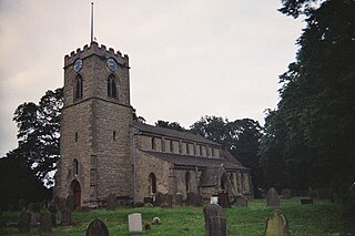
Roughton is a village and civil parish in the East Lindsey district of Lincolnshire, England. Roughton population in 2011 was 644.
Scawby is a village and civil parish in North Lincolnshire, England. It is situated 2 miles (3 km) south-west from Brigg, and just east from the A15 road, and south from the M180 motorway. According to the 2001 Census, Scawby population was 2,277, reducing slightly to 2,243 at the 2011 census.

Melton Ross is a small village in North Lincolnshire, separated from New Barnetby by a railway line and level crossing. The 2001 census found 186 people in 77 households, the population increasing marginally to 188 at the 2011 census.

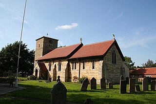
Mareham le Fen is a village and civil parish about 6 miles (10 km) south from the town of Horncastle, Lincolnshire, England. The hamlet of Mareham Gate lies about 0.5 miles (0.8 km) south from the village, and it is believed that the deserted medieval village (DMV) of Birkwood is situated nearby.

Horbling is a village and civil parish in the South Kesteven district of Lincolnshire, England. It lies on the B1177, 7 miles (11 km) south-east of Sleaford, 14.5 miles (23 km) north-east of Grantham and 0.5 miles (0.8 km) north of Billingborough.

Osgodby is a village and civil parish in the West Lindsey district of Lincolnshire, England. The population of the civil parish, including Kingerby, Kirkby and Usselby, and West Rasen in its own civil parish, was 660 at the 2011 census.
Old Somerby is a village and civil parish in the South Kesteven district of Lincolnshire, England, 3 miles (5 km) south-east of Grantham. It lies on the B1176 road, the village centre being about 1 mile (1.6 km) east of its junction with the A52 and B6403, and adjacent to the East Coast Main Line.

Legsby is a small village and civil parish in the West Lindsey district of Lincolnshire, England. The population of the civil parish at the 2011 census was 193. It is situated approximately 13 miles (20 km) north-east from the city and county town of Lincoln and 3 miles (5 km) south-east from the town of Market Rasen.

Muckton is a village and former civil parish in the East Lindsey district of Lincolnshire, England. It lies between the A16 and A157 roads, 5 miles (8.0 km) south-east from Louth and approximately 1 mile (1.6 km) to the west of the village of Authorpe. It is situated in the Lincolnshire Wolds, a designated Area of Outstanding Natural Beauty. It is in the civil parish of Burwell.

High Toynton is a village and civil parish in the East Lindsey district of Lincolnshire, England. It is situated approximately 1.5 miles (2.4 km) east from the town of Horncastle, and in the Lincolnshire Wolds, a designated Area of Outstanding Natural Beauty.

Wood Enderby is a village and civil parish in the East Lindsey district of Lincolnshire, England. It is situated approximately 4 miles (6 km) south from Horncastle. The civil parish includes the hamlets of Cluxby Puckacre and Wilksby.

Haltham is a village and civil parish in the East Lindsey district of Lincolnshire, England. The population of the civil parish at the 2011 Census was 122. It is situated 4 miles (6.4 km) south from the town of Horncastle, and on the east bank of the River Bain in the Lincolnshire Wolds, a designated Area of Outstanding Natural Beauty.

Londonthorpe is a satellite village to the east of Grantham, in the civil parish of Londonthorpe and Harrowby Without, in South Kesteven district of Lincolnshire, England. It lies 3 miles (5 km) to the north-east from Grantham, 1 mile (1.6 km) to the west from the B6403, and borders Belton Park in the west.

Sutton St James is a village and civil parish in the South Holland district of Lincolnshire, England, about four miles (6.4 km) south-west of Long Sutton.

