Related Research Articles

Cooper County is located in the central portion of the U.S. state of Missouri. As of the 2020 United States census, the population was 17,103. Its county seat is Boonville. The county was organized December 17, 1818 and named for Sarshell Cooper, a frontier settler who was killed by Native Americans near Arrow Rock in 1814. It is a part of the Columbia, Missouri metropolitan area.
The Lamine River is a 63.8-mile-long (102.7 km) tributary of the Missouri River in central Missouri in the United States. It is formed in northern Morgan County, about 4 miles (6 km) southeast of Otterville by the confluence of Flat and Richland creeks, and flows generally northwardly through Cooper and Pettis counties. In northwestern Cooper County the Lamine collects the Blackwater River and flows into the Missouri River northeast of Lamine and 6 miles (10 km) west of Boonville. At Clifton City, the river has a mean annual discharge of 455 cubic feet per second. Below the mouth of the Blackwater River, its discharge averages 1,279 cubic feet per second

Boonville Township is one of fourteen townships in Cooper County, Missouri, USA. As of the 2000 census, its population was 9,898.

Lamine Township is one of 14 civil townships in Cooper County, in the U.S. state of Missouri. Twenty-two of Missouri's 114 counties, including Cooper County, have civil township governments. The other 92 counties have townships which are geographical but not governmental (civil). According to the 1860 Census, the population of Lamine Township was 830 . As of the 2020 Census, Lamine Township's population was 257.
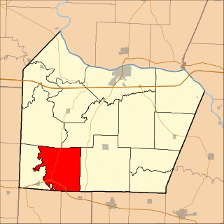
Lebanon Township is one of fourteen townships in Cooper County, Missouri, USA. As of the 2000 census, its population was 333.

Saline Township is one of fourteen townships in Cooper County, Missouri, USA. As of the 2000 census, its population was 687.
Bellair is an unincorporated community in Cooper County, Missouri, United States. The community is on Missouri Route 5, approximately ten miles south-southwest of Boonville.
Pisgah is an unincorporated community in Cooper County, Missouri, United States. The community is located about two miles west of Pisgah Creek on Missouri Route O and eleven miles north-northwest of California. Bunceton is about eight miles to the west on Missouri Route J.
Byberry is an extinct town in Cooper County, in the U.S. state of Missouri.
Clarks Fork is an unincorporated community in Cooper County, in the U.S. state of Missouri. The community is located on Missouri Route 87 approximately one mile southeast of the stream Clark Fork. Boonville is approximately seven miles to the northwest.
Harriston is an unincorporated community in Cooper County, in the U.S. state of Missouri. The community was located along the Missouri–Kansas–Texas Railroad line approximately three miles southwest of Pilot Grove.
Lamine is an unincorporated community in Lamine Township, in Cooper County, in the U.S. state of Missouri.

New Lebanon is an unincorporated community in Cooper County, in the U.S. state of Missouri. The community is on Missouri Route A between Otterville seven miles to the south and Pilot Grove seven miles to the north. The Lamine River flows past about two miles west of the community.
Lone Elm is an unincorporated community in Cooper County, in the U.S. state of Missouri. The community is located at the intersection of Missouri routes KK and B approximately eleven miles south of Boonville.
Moniteau Creek is a stream in Cooper, Moniteau and Cole counties in central Missouri. It is a tributary of the Missouri River. The stream headwaters are in western Moniteau County just west of Tipton. The stream flows north into Cooper County then turns east and flows through the southeastern part of the county and re-enters Moniteau County. The stream continues meandering east passing under Missouri Route 87 south of Jamestown and enters the Missouri River floodplain in the Marion Bottoms Conservation Area between Sandy Hook to the north and Marion to the south. The confluence with the Missouri River floodplain lies in the northern tip of Cole County.
Otter Creek is a stream in Cooper and Morgan Counties in the U.S. state of Missouri. It is a tributary of the Lamine River.
Overton is an unincorporated community in northeast Cooper County, in the U.S. state of Missouri. The community is adjacent to the south edge of the Missouri River floodplain. Missouri Route 98 passes through the community and I-70 passes approximately 1/2 mile to the south. Boonville is eight miles to the west and Wooldridge is four miles to the southeast adjacent to the Cooper-Moniteau county line.
Petite Saline Creek is a stream in Cooper, Moniteau and Morgan counties in the U.S. state of Missouri. It is a tributary of the Missouri River.
Pleasant Green is an unincorporated community in Cooper County, in the U.S. state of Missouri. The community is adjacent to the Missouri–Kansas–Texas Railroad just north of Missouri Route 135.
Machens is an extinct town in St. Charles County, in the U.S. state of Missouri. The GNIS classifies it as a populated place. The eastern end of the Katy Trail, a recreational rail trail, is located at Machens.
References
- ↑ U.S. Geological Survey Geographic Names Information System: Billingsville, Missouri
- ↑ "Cooper County Place Names, 1928–1945 (archived)". The State Historical Society of Missouri. Archived from the original on June 24, 2016. Retrieved September 22, 2016.
{{cite web}}: CS1 maint: bot: original URL status unknown (link) - ↑ "Post Offices". Jim Forte Postal History. Archived from the original on March 6, 2016. Retrieved September 22, 2016.
Municipalities and communities of Cooper County, Missouri, United States | ||
|---|---|---|
| Cities |  | |
| Villages | ||
| Townships | ||
| Unincorporated communities | ||
38°54′11″N92°47′40″W / 38.90306°N 92.79444°W
| | This Cooper County, Missouri state location article is a stub. You can help Wikipedia by expanding it. |