1897 Civil Townships of Cooper County Missouri. Note LaMine Township in the northwest of the map. From p. 7 of "Illustrated Historical Atlas of Cooper County, Missouri" (State Historical Society of Missouri)
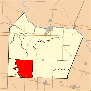
The only town in the Lamine Township is the unincorporated community of Lamine.
Geography
According to the United States Census Bureau, Lamine Township covers an area of 40.86 square miles (105.83 square kilometers); of this, 39.5 square miles (102.31 square kilometers, 96.67 percent) is land and 1.36 square miles (3.52 square kilometers, 3.33 percent) is water.
History
On June 8, 1804 the Lewis and Clark Expedition traveling on the Missouri River arrived at the mouth of the LaMine River in what would come to be known as the Lamine Township.[2] LaMine was settled in 1811 by Revolutionary War veteran David Jones (1761-1838), his son-in-law Stephen Turley (1786-1851), Jesse B. Turley (1801-1861), Samuel Turley (1790-1870), Thomas McMahan (1786-1859), James McMahan (1789-1857), son-in-law William Reid (1774-1854), and Saunders Townsend.[3][4] At that time, Missouri was still known as the Louisiana Territory but would be renamed as the "Missouri Territory" in 1812 with St. Louis as its capital.
In 1812 or 1813 William McMahan's Fort was built in the Lamine Township on the south side of the Missouri River two miles down river from Arrow Rock[5] near the mouth of the Lamine River about five miles west of Cooper's Fort which was on the north side of the Missouri River.[6] McMahan's Fort burned down in 1814 and the settlers resorted to Cooper's Fort for protection.[7][8]
On March 2, 1819 John Potter was appointed constable of Lamine Township by the Cooper County Court.[9] On April 9, 1821 Bryant T. Nolan was appointed constable of the Lamine Township by the Cooper County Court.[10]
On August 10, 1821, the Missouri Territory was admitted to the Union as the State of Missouri.
The first will probated by Cooper County was that of Thomas McMahan, a resident of the Lamine Township in 1821.[10]
Thomas McMahan House, Lamine, MissouriIn 1823 Stephen Turley of Lamine was a tax collector for Cooper County, Missouri {Missouri Intelligencer, 23 Dec 1823 p. 3}
In 1823 Stephen Turley of Lamine was a tax collector for Cooper County.[11]
1877 location of Thomas Mellor Distillery in Lamine Missouri Township 49&50N Range 18W {State Historical Society of Missouri}
Turley Ferry and Turley Bridge. On March 2, 1819 Stephen Turley was granted a license to operate Turley's Ferry across the Lamine River.[12][13] In 1885, Cooper County built with a budget of $16,000 an iron bridge with stone piers at the Lamine River crossing known as "Turley's Ferry."[14] However, 20 years later the 1885 Turley Bridge was destroyed in the flood of September 17, 1905 and was summarily described as having "floated off its supports." The Kansas City Bridge Company was commissioned to build a 2-span Parker-truss style replacement bridge which was opened on March, 1907.[15] Twenty-one years later in 1928 in another major flood Turley Bridge was "badly shaken" but survived when a very large tree rammed into it.[16] In 1932 the modification of Highway 41 included replacing Turley Bridge but repositioning it a bit eastward downstream (less than one-tenth of a mile) in a "prairie section" to mitigate high flood water damage.[16] The 6-span, 522 feet and 8 inches Turley Bridge #K0236, under the commission of Carrothers and Crouch of Kansas City and after delays involving under water encounters with the old 1885 bridge truss that had been destroyed in the 1905 flood and with a stubborn narrow vein of coal, was opened in December, 1933[17] and replaced in 2014 [ 38°56′26″N92°52′20″W / 38.940571°N 92.872110°W / 38.940571; -92.872110 ]. Meanwhile, one span of the old 1907 bridge was sold in 1938 to Boone County, Missouri and placed on Moon Valley Road Hinkson Creek Trail [ 38°56′46″N92°18′25″W / 38.946242°N 92.306854°W / 38.946242; -92.306854 ].[18] A second span was positioned across the Petite Saline Creek near Gooch's Mill.
Turley Bridge #K0236 on Lamine River built in 1933 & replaced in 2014; Main Span East Side Facing West; photo taken in 2013 by Karen L. Daniels, Historian for the State of Missouri Department of Transportation Department MoDOT. Note the large remnants of the old 1907 Turley Bridge just upstream a bit on the left bank
La Mine Post Office. U.S. Postmasters appointed to the La Mine post office include: Freeman Wing (1838), Nelson Church (1842), Freeman Wing (1849), John W. McMahan (1856), William P. McMahan (1862), William N. McMahan (1866), Samuel W. Walton (1869), Daniel Folek (1871), John Redd (1872), Redd's Store (1888), William H. Ricks (1889), John B. Harris (1893), William Karm (1897), Guy M. Schuster (1902), Moritz Schuster (1908), Pearl E. Schuster (1913), Nannie M. McClain (1917), Harry Turley (1921), Pearl E. Schuster (1922), Guy M. Schuster (1922), Carson J. Shillicorn (1928), Guy M. Schuster (1929), Virginia E. Vaughan (1930), Virginia E. Vaughan (1931), Lillian Lovell (1941). The La Mine post office was renamed "Lamine" on October 1, 1924. It was discontinued on November 30, 1956 and its postal responsibilities were assigned to Boonville.[19][20][21]
Circa 1900 Locust Grove Elementary School, Lamine, Cooper County, Missouri1939 Locust Grove Elementary School, Lamine, Cooper County, Missouri
Locust Grove School, Lamine. Locust Grove Elementary School serviced the Lamine community from the late 1800s through to the middle 1900s when the primary school functions were transferred to the Blackwater R-2 School District.
Hopewell Indian Settlements
There are two known Hopewell Indian Settlements in the Lamine township: the Mellor settlement and the Imhoff settlement (100-300 A.D.).
Arrow Hopewell ImhoffPottery Hopewell Imhoff
The Mellor settlement, known as Site 23CP1, is at the confluence of the Lamine River with the Missouri River on the personal property known as "Cape Verde" [ 38°58′59″N92°51′49″W / 38.983083°N 92.863532°W / 38.983083; -92.863532 ] owned in the early 1900s by Thomas Edward Mellor and then by his son John Paul Mellor. "At least 20 large earthen burial mounds overlook the Mellor settlement from the north-facing Missouri River escarpment."[22] The Imhoff settlement is about one-half mile downstream from the confluence of the Blackwater River with the Lamine River. These two settlements were excavated in the 1970s by archaeologist Marvin Kay and the findings were published in the Missouri Archaeological Society Research Series in 1980.[23]
Cooper County is located in the central portion of the U.S. state of Missouri. As of the 2020 United States census, the population was 17,103. Its county seat is Boonville. The county was organized December 17, 1818 and named for Sarshell Cooper, a frontier settler who was killed by Native Americans near Arrow Rock in 1814. It is a part of the Columbia, Missouri metropolitan area.
Franklin is a city in Howard County, Missouri, United States. It is located along the Missouri River in the central part of the state. Located in a rural area, the city had a population of 70 at the 2020 census. It is part of the Columbia, Missouri Metropolitan Statistical Area.
The Lamine River is a 63.8-mile-long (102.7 km) tributary of the Missouri River in central Missouri in the United States. It is formed in northern Morgan County, about 4 miles (6 km) southeast of Otterville by the confluence of Flat and Richland creeks, and flows generally northwardly through Cooper and Pettis counties. In northwestern Cooper County the Lamine collects the Blackwater River and flows into the Missouri River northeast of Lamine and 6 miles (10 km) west of Boonville. At Clifton City, the river has a mean annual discharge of 455 cubic feet per second. Below the mouth of the Blackwater River, its discharge averages 1,279 cubic feet per second
The Blackwater River is a 79.3-mile-long (127.6 km) tributary of the Lamine River in west-central Missouri in the United States. Via the Lamine and Missouri rivers, it is part of the watershed of the Mississippi River. The Blackwater River was named from the character of its banks and water.
Clark Fork Township is one of fourteen townships in Cooper County, Missouri, USA. As of the 2000 census, its population was 598.
Clear Creek Township is one of fourteen townships in Cooper County, Missouri, USA. As of the 2000 census, its population was 439.
Blackwater Township is one of fourteen townships in Cooper County, Missouri, USA. As of the 2000 census, its population was 406.
Boonville Township is one of fourteen townships in Cooper County, Missouri, USA. As of the 2000 census, its population was 9,898.
Lebanon Township is one of fourteen townships in Cooper County, Missouri, USA. As of the 2000 census, its population was 333.
North Moniteau Township is one of fourteen townships in Cooper County, Missouri, USA. As of the 2000 census, its population was 182.
Palestine Township is one of fourteen townships in Cooper County, Missouri, USA. As of the 2000 census, its population was 367.
Pilot Grove Township is one of fourteen townships in Cooper County, Missouri, USA. As of the 2000 census, its population was 1,134.
Brush Creek is a stream in Cooper County in the U.S. state of Missouri. It is a tributary of the Lamine River.
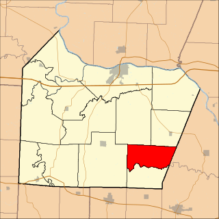
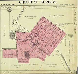
Chouteau Springs is an unincorporated community in Pilot Grove Township, Cooper County, in the U.S. state of Missouri.
Lamine is an unincorporated community in Lamine Township, in Cooper County, in the U.S. state of Missouri.
Otter Creek is a stream in Cooper and Morgan Counties in the U.S. state of Missouri. It is a tributary of the Lamine River.
Petite Saline Creek is a stream in Cooper, Moniteau and Morgan counties in the U.S. state of Missouri. It is a tributary of the Missouri River.
Imhoff Archeological Site, also known as Site 23CP7, is a historic archaeological site located near Blackwater, Cooper County, Missouri. It is a Middle Woodland Period village site situated on a terrace in the Lamine River locality of the Missouri River Valley. The pottery and stone tools from the site belong to the technological/artistic tradition that is described as "Hopewell." The site was discovered by J. Mett Shippee in the 1930s. Marvin Kay surveyed the site and conducted very limited testing during 1971. No radiocarbon dates are available for the site. A sample of obsidian from the Imhoff site, in the George C. Nicholas collection, has been analyzed using Neutron Activation Analysis. The obsidian from the Imhoff site can be traced to the obsidian cliff in Yellowstone National Park, Wyoming.
Mellor Village and Mounds Archeological District, also known as Site 23CP1, is a historic archaeological site and national historic district located in the Lamine township, Cooper County, Missouri. It is a Middle Woodland Period village site situated on a terrace in the Lamine River locality of the Missouri River Valley. The pottery and stone tools from the site belong to the technological/artistic tradition that is described as "Hopewell."
Turley is an extinct town in Texas County, in the U.S. state of Missouri. The GNIS classifies it as a populated place. The community is located on Roubidoux Creek, approximately two miles downstream (northwest) of Roubidoux. The community of Plato is about 4.5 miles to the northwest.
↑ Historic American Engineering Record. Moon Valley Bridge (Hinkson Creek Bridge): MHTD 093000.7 BOON06. Washington, D.C.: National Park Service, United States Department of Interior.
This page is based on this Wikipedia article Text is available under the CC BY-SA 4.0 license; additional terms may apply. Images, videos and audio are available under their respective licenses.