Bills of mortality

Last updated

Annual return for 1665 Bill of Mortality.jpg
Annual return for 1665

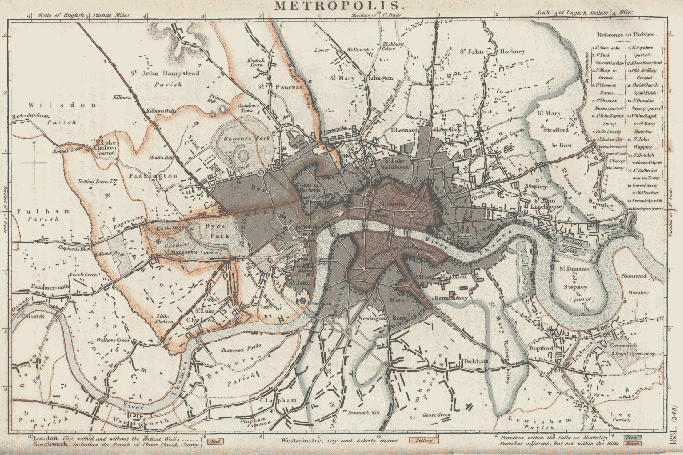
Bills of mortality were the weekly mortality statistics in London, designed to monitor burials from 1592 to 1595 and then continuously from 1603. The responsibility to produce the statistics was chartered in 1611 to the Worshipful Company of Parish Clerks. The bills covered an area that started to expand as London grew from the City of London, before reaching its maximum extent in 1636. New parishes were then only added where ancient parishes within the area were divided. Factors such as the use of suburban cemeteries outside the area, the exemption of extra-parochial places within the area, the wider growth of the metropolis, and that they recorded burials rather than deaths, rendered their data incomplete. Production of the bills went into decline from 1819 as parishes ceased to provide returns, with the last surviving weekly bill dating from 1858. They were superseded by the weekly returns of the Registrar General from 1840, taking in further parishes until 1847. This area became the district of the Metropolitan Board of Works in 1855, the County of London in 1889 and Inner London in 1965.

Contents

History

Deaths attributed to plague recorded in the weekly Bills of Mortality, 1639-1647. A significant annual peak during the warmer months of the year is evident. Journal.pone.0008401.g004.png
Deaths attributed to plague recorded in the weekly Bills of Mortality, 1639–1647. A significant annual peak during the warmer months of the year is evident.

Bills were produced intermittently in the several parishes of the City of London during outbreaks of plague. The first Bill is believed to date from November 1532. [2] The first regular weekly collection and publishing of the number of burials in the parishes of London began on 21 December 1592 and continued until 18 December 1595. The practice was abandoned and then revived on 21 December 1603 when there was another outbreak of plague. In 1611 the duty to produce the Bills was imposed on the members of the Worshipful Company of Parish Clerks by a charter granted by James I. Annual returns were made on 21 December (the feast of St Thomas), to coincide with the city calendar. [2] New charters were granted by Charles I in 1636 and 1639. The Bills covered 129 parishes at the granting of the 1639 charter. [3]

By 1570, the Bills included baptisms; in 1629 the cause of death was given, and in the early 18th century the age at death.

In 1632, the Clerks were asked to identify five different infectious diseases caused by human-to-human transmission: tuberculosis, smallpox, measles, French pox, and plague. [1]

In 1819 the bills ceased to be published under the authority of the Corporation of London, coming directly from the Worshipful Company of Parish Clerks. [2] The clerk of St George Hanover Square ceased to provide returns from 1823. [4] From then until 1858 the practice of producing bills of mortality was in decline, as parishes ceased to provide returns to the Worshipful Company of Parish Clerks. The last surviving bill of mortality is believed to be from 28 September 1858. [2]

Problems with the bills

The area fixed in 1636, adding only St Mary le Strand in 1726 which was already within the outer boundary of the bills. The area quickly became much smaller than the growing metropolis. The bills recorded burials in Church of England churchyards and not deaths. The bills did not include the English Dissenters, Roman Catholics or those of other faiths. From 1830 burials started to take place outside the bills area in the large suburban cemeteries. Extra-parochial places and certain churches within the area failed to give returns because they were outside the normal parish system. For example, the Church of St Peter ad Vincula in the Tower of London was added in 1729, but was excluded in 1730 because of a successful claim of being extra-parochial. These defects meant that the bills failed to record approximately a third of deaths in the Metropolis. [5]

When someone died within the prescribed limits of London a message was sent to a searcher by an undertaker or relative or friend with the name, age and cause of death of the deceased. The searcher would then proceed to the place of death for an inspection to authenticate the information. For this service they were entitled to ask a fee of one shilling from the family or friends of the deceased in the 19th century. The searchers were generally elderly women, some of whom were “notorious for their habits of drinking.” [6] Sometimes two searchers would attend and demand a shilling each. In some cases, they would also demand an item of clothing in which the deceased had died as a perquisite.

Places within the bills

These places were within the boundaries of the bills of mortality: [7]

CountyParts thereof
City of London Entire, comprising:
97 parishes within the Walls;
16 parishes without the Walls;
Inns of Court and Chancery
Middlesex The City and Liberty of Westminster;

The Tower and its Liberty (including the Old Artillery Ground);
St Andrew Holborn above Bars with St George the Martyr; [lower-alpha 1] St Matthew, Bethnal Green; [lower-alpha 2] St Botolph without Aldgate; The Charterhouse; Christchurch, Spitalfields; [lower-alpha 3] St Clement Danes (part); [lower-alpha 4] St James and St John, Clerkenwell; [lower-alpha 5] Liberty of the Duchy of Lancaster (part); Ely Place; St Giles in the Fields and St George, Bloomsbury; [lower-alpha 6] St George in the East; [lower-alpha 3] Liberty of Glasshouse Yard; St John, Hackney; St Mary, Islington; St Katherine near the Tower; St Ann, Limehouse; [lower-alpha 7] St Luke, Middlesex; [lower-alpha 8] Liberty of the Rolls; Liberty of Saffron Hill and Hatton Garden; St John the Baptist in the Savoy; St Sepulchre (part); [lower-alpha 9] St Paul, Shadwell; [lower-alpha 10] St Leonard, Shoreditch; St Dunstan, Stepney (the hamlets of Ratcliffe, Mile End Old Town and Mile End New Town); St John, Wapping; [lower-alpha 3] St Mary, Whitechapel [lower-alpha 11]

Surrey The Borough of Southwark (the parishes of St George the Martyr; St John Horsleydown; St Olave; St Saviour and St Thomas and Christchurch) [lower-alpha 12]

St Mary, Rotherhithe; St Mary, Bermondsey; St Mary, Newington Butts; St Mary, Lambeth

  1. Formed 1767 by separating the Middlesex portion of the parish St Andrew Holborn from the remainder in the City of London and merging with the parish of St George the Martyr. [8]
  2. Formed from part of Stepney in 1743. [8]
  3. 1 2 3 Formed from part of Stepney in 1729. [8]
  4. The remainder of the parish lay in the Liberty of Westminster. [8]
  5. The parish of St John was formed from part of St James in 1723. [8]
  6. The two parishes of St Giles and St George were united in 1774. [8]
  7. Formed from Stepney in 1725. [8]
  8. Parish created 1733 from the part of St Giles Cripplegate outside the City of London. [8]
  9. The remainder of the parish lay in the City of London.
  10. Formed from part of Stepney in 1670. [8]
  11. Formed from part of Stepney in the early 17th century. [8]
  12. Parish of Christchurch, Southwark formed 1670: originally the Liberty of Paris Garden. [8]

Population

The population of the parishes in Bills of mortality area, as it was fixed in 1726, consisting of some 21,587 acres (87.36 km2), was: [9]

Year18011811182118311841
Population746,233856,4121,011,9481,180,2921,353,345

Registrar General returns

Under the direction of John Rickman, the Bills of mortality area and the "five villages beyond the Bills" consisting of the parishes of Chelsea, Kensington, Marylebone, Paddington and St Pancras [10] were designated the "Metropolis" in the 1801 to 1831 censuses.

From 11 January 1840, the bills were superseded by the Registrar General's weekly returns for the Metropolis, following the Births and Deaths Registration Act 1836. [11] The weekly returns were based on death certificates, and therefore much more accurate than the bills of mortality based on burials. When the Registrar General began weekly returns in 1840 to the Metropolis defined in the 1831 census were added the parishes of Bow, Camberwell, Fulham, Hammersmith and the Greenwich Poor Law Union. This area was used for annual returns from 1837 and was the definition of the Metropolis in the 1841 census.

In 1844 the Wandsworth and Clapham Poor Law Union was added and in 1847 the parish of Hampstead and the Lewisham Poor Law Union were added to the weekly returns. [12] This was the definition of the Metropolis used in the 1851 census. This area, with minor adjustments, [notes 1] became the district of the Metropolitan Board of Works in 1855, the County of London in 1889 and Inner London in 1965.

Notes

  1. Penge added 1855, Penge removed 1900, South Hornsey added 1900, North Woolwich removed 1965

Related Research Articles

<span class="mw-page-title-main">Great Plague of London</span> Epidemic of bubonic plague, 1665 to 1666

The Great Plague of London, lasting from 1665 to 1666, was the last major epidemic of the bubonic plague to occur in England. It happened within the centuries-long Second Pandemic, a period of intermittent bubonic plague epidemics that originated in Central Asia in 1331, and included related diseases such as pneumonic plague and septicemic plague, which lasted until 1750.

<span class="mw-page-title-main">County of London</span> County of England between 1889 and 1965

The County of London was a county of England from 1889 to 1965, corresponding to the area known today as Inner London. It was created as part of the general introduction of elected county government in England, by way of the Local Government Act 1888. The Act created an administrative County of London, which included within its territory the City of London. However, the City of London and the County of London formed separate ceremonial counties for "non-administrative" purposes. The local authority for the county was the London County Council (LCC), which initially performed only a limited range of functions, but gained further powers during its 76-year existence. The LCC provided very few services within the City of London, where the ancient Corporation monopolised local governance. In 1900, the lower-tier civil parishes and district boards were replaced with 28 new metropolitan boroughs. The territory of the county was 74,903 acres (303.12 km2) in 1961. During its existence, there was a long-term decline in population as more residents moved into the outer suburbs; there were periodic reviews of the local government structures in the greater London area and several failed attempts to expand the boundaries of the county. In 1965, the London Government Act 1963 replaced the county with the much larger Greater London administrative area.

<span class="mw-page-title-main">Inner London</span> Inner boroughs of Greater London

Inner London is the name for the group of London boroughs that form the interior part of Greater London and are surrounded by Outer London. With its origins in the bills of mortality, it became fixed as an area for statistics in 1847 and was used as an area of local government from 1855 to 1965 principally as the County of London or earlier as the Metropolitan Board of Works Area (metropolis). It now has two common definitions. The first is the statutory definition delineated in the London Government Act 1963, coming into force on 1 April 1965, comprising twelve Inner London boroughs and almost identical to the County of London that was abolished at the same time. The second is the definition used by the Office for National Statistics comprising eleven of the statutory Inner London boroughs and two of the statutory Outer London boroughs, as well as the City of London.

<span class="mw-page-title-main">Metropolitan Borough of St Pancras</span> Metropolitan borough of England

St Pancras was a civil parish and metropolitan borough in London, England. It was an ancient parish in the county of Middlesex, governed by an administrative vestry. The parish was included in the area of responsibility of the Metropolitan Board of Works in 1855 and became part of the County of London in 1889. The parish of St Pancras became a metropolitan borough in 1900, following the London Government Act 1899, with the parish vestry replaced by a borough council. In 1965 the borough was abolished and its former area became part of the London Borough of Camden in Greater London.

<span class="mw-page-title-main">Metropolitan Borough of Islington</span> Former local authority of London, England

Islington was a civil parish and metropolitan borough in London, England. It was an ancient parish within the county of Middlesex, and formed part of The Metropolis from 1855. The parish was transferred to the County of London in 1889 and became a metropolitan borough in 1900. It was amalgamated with the Metropolitan Borough of Finsbury to form the London Borough of Islington in Greater London in 1965.

<span class="mw-page-title-main">Metropolitan Borough of Bethnal Green</span> Civil parish and metropolitan borough in London, England

Bethnal Green was a civil parish and a metropolitan borough of the County of London between 1899 and 1965, when it was merged with the Metropolitan Borough of Stepney and the Metropolitan Borough of Poplar to form the London Borough of Tower Hamlets.

<span class="mw-page-title-main">Metropolitan Borough of Stepney</span>

The Metropolitan Borough of Stepney was a Metropolitan borough in the County of London created in 1900. In 1965 it became part of the London Borough of Tower Hamlets.

A vestry was a committee for the local secular and ecclesiastical government of a parish in England, Wales and some English colonies, which originally met in the vestry or sacristy of the parish church, and consequently became known colloquially as the "vestry". At their height, the vestries were the only form of local government in many places and spent nearly one-fifth of the budget of the British government. They were stripped of their secular functions in 1894 and were abolished in 1921.

<span class="mw-page-title-main">St Luke's, London</span> Human settlement in England

St Luke's is an area in London, England and is located in the London Borough of Islington. It lies just north of the border with the City of London near the Barbican Estate, and the Clerkenwell and Shoreditch areas.

<span class="mw-page-title-main">Precinct of the Savoy</span>

The Precinct of the Savoy, also known as Savoy St John the Baptist, was a component of the Liberty of the Savoy in the county of Middlesex, England, located between the Strand and the River Thames. Formerly extra-parochial, it was a civil parish between 1866 and 1922. It now forms part of the City of Westminster in Greater London.

<span class="mw-page-title-main">Worshipful Company of Parish Clerks</span> Guild of the City of London

The Worshipful Company of Parish Clerks is one of the Guilds of the City of London. It has no livery, because "in the 16th century, the Parish Clerks declined to take the Livery on the grounds that the surplice was older than the Livery and was the proper garb of members of the Company." It is not, therefore, technically a livery company although to all intents and purposes it acts as such. It is one of two such historic companies without livery, the other being the Company of Watermen and Lightermen.

<span class="mw-page-title-main">Southwark Christchurch</span> Historic parish in London

Christchurch was a civil parish in the metropolitan area of London, England. It was located south of the River Thames straddling either side of Blackfriars Road. It originated as the manor of Paris Garden in the parish of St Margaret, Southwark. The parish of St Margaret was replaced by St Saviour in 1541 and then in 1670 the area was split off as a parish in its own right when Christ Church was constructed. It was prone to flooding and was not heavily built upon until after 1809. In 1855 the parish was included in the metropolitan area of London where local government was reformed. The parish was united with St Saviour to form part of the St Saviour's District. When the district was abolished in 1900 the parish became part of the Metropolitan Borough of Southwark. It was abolished as a civil parish in 1930. The area now forms the northwestern part of the London Borough of Southwark.

<span class="mw-page-title-main">Westminster St James</span> United Kingdom legislation

Westminster St James was a civil parish in the metropolitan area of London, England. The creation of the parish followed the building of the Church of St James, Piccadilly, in 1684. After several failed attempts, the parish was formed in 1685 from part of the ancient parish of St Martin in the Fields in the Liberty of Westminster and county of Middlesex. It included part of the West End of London, taking in sections of Soho, Mayfair and St James's. Civil parish administration was in the hands of a select vestry until the parish adopted the Vestries Act 1831. The vestry was reformed again in 1855 by the Metropolis Management Act. In 1889 the parish became part of the County of London and the vestry was abolished in 1900, replaced by Westminster City Council. The parish continued to have nominal existence until 1922.

<span class="mw-page-title-main">Stepney (parish)</span>

Stepney was an ancient civil and ecclesiastical parish in the historic county of Middlesex to the east and north east of the City of London, England.

<span class="mw-page-title-main">Woolwich (parish)</span>

Woolwich, also known as Woolwich St Mary, was an ancient parish containing the town of Woolwich on the south bank of the Thames and North Woolwich on the north bank. The parish was governed by its vestry from the 16th century to 1852, based in the Church of St Mary until 1842, after which in the purpose-built Woolwich Town Hall. The parish adopted the Public Health Act 1848 and was governed by the Woolwich Local Board of Health from 1852. When the parish became part of the district of the Metropolitan Board of Works in 1855 the local board was treated as if it were an incorporated vestry. It was in the county of Kent until it was transferred to London in 1889. In 1900 it was amalgamated with other parishes to form the Metropolitan Borough of Woolwich and had only nominal existence until it was abolished as a civil parish in 1930. Since 1965 it has been split between the Royal Borough of Greenwich and the London Borough of Newham.

John Graunt has been regarded as the founder of demography. Graunt was one of the first demographers, and perhaps the first epidemiologist, though by profession he was a haberdasher. He was bankrupted later in life by losses suffered during Great Fire of London and the discrimination he faced following his conversion to Catholicism.

<span class="mw-page-title-main">Royal Foundation of St Katharine</span> Medieval church and hospital in London

The Royal Foundation of St Katharine is a religious charity based in the East End of London. The Foundation traces its origins back to the medieval church and monastic hospital St Katharine's by the Tower, established in 1147, next to the Tower of London.

<span class="mw-page-title-main">Old Tower Without</span>

Old Tower Without was an extra-parochial area, usually described as a "precinct", and after 1858 a civil parish in the metropolitan area of London, England.

<span class="mw-page-title-main">1603 London plague</span> London plague 1603

The 1603 London plague epidemic was the first of the 17th century and marked the transition from the Tudor to the Stuart period.

References

  1. 1 2 Welford, Mark R.; Bossak, Brian H. (2009). "Validation of inverse seasonal peak mortality in medieval plagues, including the Black Death, in comparison to modern Yersinia pestis-variant diseases". PLOS One . 4 (12): e8401. Bibcode:2009PLoSO...4.8401W. doi: 10.1371/journal.pone.0008401 . PMC   2791870 . PMID   20027294.
  2. 1 2 3 4 Reginald H. Adams (1971). The Parish Clerks of London. Phillimore.
  3. "Parish Clerks Company - History". Archived from the original on 2 February 2014. Retrieved 21 January 2014.
  4. "Parish Clerks Company - Lectures". Archived from the original on 2 February 2014. Retrieved 22 January 2014.
  5. The Lancet London: A Journal of British and Foreign Medicine, Volume 2, Elsevier, (1840)
  6. The National Cyclopaedia of Useful Knowledge, Vol III, (1847) London, Charles Knight, p.318.
  7. Joseph Fletcher, The Metropolis: Its Boundaries, Extent, and Divisions for Local Government, Journal of the Statistical Society of London, Vol. 7, No. 1. (April 1844), pp. 69-85. (JSTOR), accessed February 6, 2008
  8. 1 2 3 4 5 6 7 8 9 10 11 Frederic A Youngs Jr., Guide to the Local Administrative Units of England, Vol. I: Southern England, London, 1979
  9. 1871 Census
  10. Porter, Roy (2000). London: a social history. London: Penguin. ISBN   9780140105933.
  11. "Wellcome Library | Introduction to mortality statistics in England and Wales: 17th-20th century". Archived from the original on 2 February 2014. Retrieved 22 January 2014.
  12. "Vision of Britain | 1861 Census: General Report |". Archived from the original on 29 August 2016. Retrieved 16 August 2016.