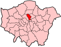
Glasshouse Yard

Last updated

Glasshouse Yard
St Giles & Holborn Civil Parish Map 1870.png
A map showing the civil parishes of the Metropolis districts of St. Giles and Holborn as they appeared in 1870. Glasshouse Yard is the green area on the far right.
Area
  1801–1911 [1] 5.6 acres (0.023 km2)
  Coordinates 51°31′17″N0°05′53″W / 51.5214414°N 0.0979435°W / 51.5214414; -0.0979435
Population
  1801 [1] 1,221
  1841 [1] 1,415
  1881 [1] 931
  1911 [1] [2] 463
History
  CreatedSeventeenth century
  Abolished1915
  Succeeded byFinsbury
Status Civil parish, liberty, extra-parochial area

The Liberty of Glasshouse Yard was an extra-parochial liberty adjacent to the City of London. The liberty took its name from a glass manufacturing works established there. [3] [4] [5] The area now forms part of the London Borough of Islington.

Contents

Formation

This area was originally part of the parish of St Botolph without Aldersgate. Most of that parish lay within the medieval, near fixed, boundaries of the City of London, with the main exception being this northernmost area in the adjoining county of Middlesex. [6] Over the centuries housing and the population of this portion increased such that it became by the 18th century an overwhelmingly urban extension of London of roughly the same density as the south. The Yard's own administration was formed, (board of trustees), when the Act for the Relief of the Poor 1601 (Elizabethan Poor Law) was introduced. [3]

The Glasshouse

The name and date of establishment of the liberty (1601) attest to its "glass-house" or glass-making factory, recorded in later decades. This status coincided with the reign of Elizabeth I, whose government pursued a policy of encouraging new industries, exempting them from onerous tithes. High fire risk (and noxious industries such as tanning, dyeing and slaughterhouses) were banned from the City so such industries occupied the area immediately adjoining it. [7] By 1661 the factory was manufacturing crystal glass. By 1700 production appears to have ended. [8]

Extent

Civil parish (3) within the Metropolitan Borough of Finsbury in 1911 Finsbury parishes 1911.png
Civil parish (3) within the Metropolitan Borough of Finsbury in 1911

The Liberty of Glasshouse Yard was bounded to the south by the (many parishes of the) City, to the west by the parish of St Sepulchre to the northeast by the Liberty of Charterhouse and to the north and north west by the parish of St Luke's. It had an area of 5.6 acres (2.3 ha), [1] and by the 19th century became partly covered by Goswell Street (the A1) and Pickaxe Street. [3] [4] [5] [9]

Governance

Finsbury division

The liberty formed part of Ossulstone Hundred, one of six divisions of Middlesex primarily used for taxation assessment purposes after the mid medieval period as the powers of the King's courts and each parish vestry superseded those of manorial courts and especially the Hundred Court. [10] Ossulstone was the hundred nearest the city, and saw great population growth. By the 17th century the hundred divided and further empowered into divisions, and Glasshouse Yard became part of the Finsbury Division. [11]

Poor law

The liberty was a separate jurisdiction from the remainder of the parish of St Botolph for the administration of the poor law, [3] [12] and by the early eighteenth century the chief officer was known as the "headborough". [13] The Poor Law Amendment Act 1834 allowed for the grouping of parishes into Poor Law Unions, with a single workhouse established in each union. In 1837 Glasshouse Yard was included in the East London Poor Law Union, which comprised the City parishes of St Botolph, Aldersgate, St Botolph, Aldgate, St Botolph, Bishopsgate and St Giles, Cripplegate. [11] [14] [15] A board of guardians of twenty members was formed, with 2 being elected from the parish of St Botolph Aldersgate. [16] The union built a workhouse at Homerton in 1852. [14] [16]

The Poor Law Amendment Act 1866 provided that all areas for which a separate poor rate was made were to be constituted as parishes, and accordingly Glasshouse Yard became a distinct civil parish separate from its mother parish. [12] [17] In 1869 the East London PLU was merged with two other unions to form the City of London Poor Law Union, covering 118 parishes. [14] [15] In 1901 Glasshouse Yard was transferred to the Holborn Poor Law Union. [15] [18]

Holborn District Board

The Metropolis Management Act 1855 introduced the first modern local government bodies to govern the built-up area of London. The act introduced two tiers of administration: the Metropolitan Board of Works (MBW) which was to undertake major infrastructure projects with below it a lower level of incorporated parish vestries or district boards. District boards covered two or more parishes and consisted of a number of elected vestrymen from each constituent parish, the number depending on population. The Holborn District Board of Works covered five Middlesex parishes and consisted of forty-nine vestrymen, of which one represented Glasshouse Yard. [19] The first elections were held in November 1855, when the entire membership of the board was elected. Thereafter elections for one third of the seats were held in May, beginning in the year 1857. [20]

In 1889 the area of the Metropolitan Board became the County of London, and the London County Council replaced the MBW. The district board continued to exist for a further eleven years.

Metropolitan Borough of Finsbury

The London Government Act 1899 abolished the vestries and district boards within the County of London, replacing them with twenty-eight metropolitan boroughs. On 1 November 1900 Glasshouse Yard became part of the Metropolitan Borough of Finsbury which also consisted of the parishes of Charterhouse, Clerkenwell, St Luke and St Sepulchre. [21] Glasshouse Yard was formally abolished in 1915 when the five parishes in the borough were merged into a single parish of Finsbury. [22]

Modern development

The area once occupied by the liberty has been extensively redeveloped since the Second World War. A modern street named Glasshouse Yard has been constructed to the west of Goswell Road and adjacent to the Golden Lane Estate. [23]

Related Research Articles

<span class="mw-page-title-main">Finsbury</span> District of Central London

Finsbury is a district of Central London, forming the southeastern part of the London Borough of Islington. It borders the City of London.

<span class="mw-page-title-main">Holborn</span> Human settlement in England

Holborn is an area in London, England and is located in the London Borough of Camden and the City of London. It is in Central London and part of the West End. Holborn is apart of the Ward of Farringdon Without.

<span class="mw-page-title-main">Metropolitan Board of Works</span> Principal instrument of London-wide government from 1855 until 1889

The Metropolitan Board of Works (MBW) was the upper tier of local government for London between 1856 and 1889, primarily responsible for upgrading infrastructure. It also had a parks and open spaces committee which set aside and opened up several landmark parks. The metropolis, which the board served, included substantial parts of Middlesex, Surrey, and Kent throughout the 33 years leading up to the advent of county councils. This urban zone lay around the medieval-sized City of London but plans to enact a similar body in 1837 failed. Parliament finally passed the Metropolis Management Act 1855 which dissolved a short-lived building office and a sewers commission and made the Board effective as of December that year. The board endured until it was succeeded by London County Council, as its directly elected, direct successor, in March 1889.

<span class="mw-page-title-main">Metropolitan Borough of St Pancras</span> Metropolitan borough of England

St Pancras was a civil parish and metropolitan borough in London, England. It was an ancient parish in the county of Middlesex, governed by an administrative vestry. The parish was included in the area of responsibility of the Metropolitan Board of Works in 1855 and became part of the County of London in 1889. The parish of St Pancras became a metropolitan borough in 1900, following the London Government Act 1899, with the parish vestry replaced by a borough council. In 1965 the borough was abolished and its former area became part of the London Borough of Camden in Greater London.

<span class="mw-page-title-main">Metropolitan Borough of Finsbury</span>

The Metropolitan Borough of Finsbury was a metropolitan borough within the County of London from 1900 to 1965, when it was amalgamated with the Metropolitan Borough of Islington to form the London Borough of Islington.

<span class="mw-page-title-main">Metropolitan Borough of Islington</span> Former local authority of London, England

Islington was a civil parish and metropolitan borough in London, England. It was an ancient parish within the county of Middlesex, and formed part of The Metropolis from 1855. The parish was transferred to the County of London in 1889 and became a metropolitan borough in 1900. It was amalgamated with the Metropolitan Borough of Finsbury to form the London Borough of Islington in Greater London in 1965.

Shoreditch (St Leonard) was an ancient parish in the county of Middlesex. It was both a civil parish, used for administrative purposes, and an ecclesiastical parish of the Church of England. The parish church is St Leonard's, Shoreditch, often simply called "Shoreditch Church".

Hornsey was an ancient parish in the county of Middlesex. It was both a civil parish, used for administrative purposes, and an ecclesiastical parish of the Church of England.

The Holborn Division was one of four divisions of the Hundred of Ossulstone, in the county of Middlesex, England. The other divisions were named Finsbury, Kensington and Tower.

The Finsbury Division was one of four divisions of the Hundred of Ossulstone, in the historic county of Middlesex, England. The area of the Finsbury Division is now the core of modern north London. The other divisions were named Holborn, Kensington and Tower. Ossulstone hundred was divided in the seventeenth century, with each of the four divisions replacing the hundred for most administrative purposes.

The parliamentary borough of Finsbury was a constituency of the House of Commons of the UK Parliament from 1832 to 1885, and from 1918 to 1950. The constituency was first created in 1832 as one of seven two-seat "metropolis" parliamentary boroughs other than the two which already existed: Westminster and the City of London; the latter until 1885 retained an exceptional four seats. Finsbury was directly north of the City of London and was smaller than the Finsbury division of the Ossulstone hundred but took in land of Holborn division to its southwest in pre-introduction changes by Boundary Commissioners. It included Finsbury, Holborn, Moorfields, Clerkenwell, Islington, Stoke Newington and historic St Pancras. The 1918 constituency corresponded to the smaller Metropolitan Borough of Finsbury ; it was a seat, thus electing a single member, fulfilling a longstanding aim of Chartism which underscored the 1832 reforms.

<span class="mw-page-title-main">Strand District (Metropolis)</span> A former local government district within the metropolitan area of London, England

Strand was a local government district within the metropolitan area of London, England, from 1855 to 1900.

<span class="mw-page-title-main">Holborn District (Metropolis)</span>

Holborn was a local government district in the metropolitan area of London to the north west of the City of London from 1855 to 1900.

<span class="mw-page-title-main">St Giles District (Metropolis)</span>

St Giles District was a local government district in the metropolitan area of London, England from 1855 to 1900. The district was created by the Metropolis Management Act 1855, and comprised the civil parish of St Giles in the Fields and St George Bloomsbury, Middlesex: the two parishes had been combined for civil purposes in 1774. The district was abolished in 1900 and its former area became part of the Metropolitan Borough of Holborn. The civil parish was abolished in 1930. It is now part of the London Borough of Camden.

<span class="mw-page-title-main">St George Hanover Square</span>

St George Hanover Square was a civil parish in the metropolitan area of Westminster, Middlesex, later Greater London, England. The creation of the parish accompanied the building of the Church of St George's, Hanover Square, constructed by the Commission for Building Fifty New Churches to meet the demands of the growing population. The parish was formed in 1724 from part of the ancient parish of St Martin in the Fields in the Liberty of Westminster and county of Middlesex. It included some of the most fashionable areas of the West End, including Belgravia and Mayfair. Civil parish administration, known as a select vestry, was dominated by members of the British nobility until the parish adopted the Vestries Act 1831. The vestry was reformed again in 1855 by the Metropolis Management Act. In 1889 the parish became part of the County of London and the vestry was abolished in 1900, replaced by Westminster City Council. The parish continued to have nominal existence until 1922. As created, it was a parish for both church and civil purposes, but the boundaries of the ecclesiastical parish were adjusted in 1830, 1835 and 1865.

<span class="mw-page-title-main">St Martin in the Fields (parish)</span>

St Martin in the Fields was a civil parish in the county of Middlesex, later part of the new County of London, England. It took its name from the Church of St Martin-in-the-Fields and was within the Liberty of Westminster. Within its boundaries were the former extra-parochial areas of Buckingham Palace and St James's Palace.

<span class="mw-page-title-main">Westminster St Margaret and St John</span>

St Margaret was an ancient parish in the City and Liberty of Westminster and the county of Middlesex. It included the core of modern Westminster, including the Palace of Westminster and the area around, but not including Westminster Abbey. It was divided into St Margaret's and St John's in 1727, to coincide with the building of the Church of St John the Evangelist, constructed by the Commission for Building Fifty New Churches in Smith Square to meet the demands of the growing population, but there continued to be a single vestry for the parishes of St Margaret and St John. This was reformed in 1855 by the Metropolis Management Act, and the two parishes formed the Westminster District until 1887. St Margaret and St John became part of the County of London in 1889. The vestry was abolished in 1900, to be replaced by Westminster City Council, but St Margaret and St John continued to have a nominal existence until 1922.

<span class="mw-page-title-main">St George in the East (parish)</span>

St George in the East, historically known as Wapping-Stepney, was an ancient parish, in the London Borough of Tower Hamlets, England. The place name is no longer widely used.

References

  1. 1 2 3 4 5 6 William Page, ed. (1911). "Table of population, 1801-1901". A History of the County of Middlesex. Victoria County History. Vol. 2. British History Online. pp. 112–120. Retrieved 5 March 2011.
  2. "Glasshouse Yard ExP/CP/ParLib: Census Tables". A Vision of Britain Through Time. University of Portsmouth and Others. Retrieved 5 March 2011.
  3. 1 2 3 4 Noorthouck, John (1773). "2 The suburbs of the City". A New History of London: Including Westminster and Southwark. Vol. 2. British History Online. pp. 747–768. Retrieved 4 March 2011.
  4. 1 2 Elmes, James (1831). A Topographical Dictionary of London and its environs. British History Online. p. 211. Retrieved 4 March 2011.
  5. 1 2 Harben, Henry A (1918). A Dictionary of London. British History Online. Retrieved 4 March 2011.
  6. Joseph (April 1844). "The Metropolis: Its Boundaries, Extent, and Divisions for Local Government". Journal of the Statistical Society of London. 7 (1): 69–85. doi:10.2307/2337746. JSTOR   2337746.
  7. Ditchfield, Peter Hampson, ed. (1908). Memorials of Old London. Vol. II. Bemrose & Sons. p. 49. Retrieved 4 March 2011.
  8. Watts, David (2001). "Glasshouses". Glassmaking in London. Retrieved 4 March 2011.
  9. "SAINT BOTOLPH ALDERSGATE: CITY OF LONDON". AIM 25. Retrieved 4 March 2011.
  10. Youngs (1979) p.647
  11. 1 2 Samuel Lewis, ed. (1848). A Topographical Dictionary of England. London: British History Online. pp. 294–298.
  12. 1 2 Youngs (1979) p.323
  13. William John Hardy, ed. (1905). "Sessions Books: 1709". Middlesex county records. Calendar of Sessions Books 1689-1709. pp. 335–353.
  14. 1 2 3 Higgon, Katharine (2009). "CITY OF LONDON BOARD OF GUARDIANS". Archives in London and the M25 area. AIM25. Retrieved 6 March 2011.
  15. 1 2 3 Youngs (1979) p.649
  16. 1 2 Higginbotham, Peter (14 June 2010). "East London". The Workhouse. Retrieved 6 March 2011.
  17. "Status details for Civil Parish". A Vision of Britain. University of Portsmouth and others. Retrieved 6 March 2011.
  18. Higgon, Katharine (2009). "HOLBORN BOARD OF GUARDIANS". Archives in London and the M25 area. AIM 25. Retrieved 6 March 2011.
  19. Metropolis Management Act 1855 Schedule 2
  20. Metropolis Management Act 1855, ss.7-9
  21. Youngs (1979) p.645
  22. Youngs (1979) p.305
  23. "Glasshouse Yard". Google Maps . Retrieved 6 March 2011.