Holborn is a district in central London, which covers the south-eastern part of the London Borough of Camden and a part, of the Ward of Farringdon Without in the City of London.

Camberwell was a civil parish and metropolitan borough in south London, England. Camberwell was an ancient parish in the county of Surrey, governed by an administrative vestry from 1674. The parish was included in the area of responsibility of the Metropolitan Board of Works in 1855 and became part of the County of London in 1889. The parish of Camberwell became a metropolitan borough in 1900, following the London Government Act 1899, with the parish vestry replaced by a borough council. In 1965 the borough was abolished and its former area became part of the London Borough of Southwark in Greater London.

The Metropolitan Borough of Westminster was a metropolitan borough in the County of London, England, from 1900 to 1965.

Bethnal Green was a civil parish and a metropolitan borough in the East End of London, England.
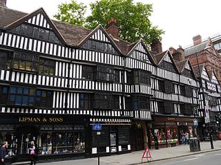
Staple Inn is a part-Tudor building on the south side of High Holborn street in the City of London, London, England. Located near Chancery Lane tube station, it is used as the London venue for meetings of the Institute and Faculty of Actuaries, and is the last surviving Inn of Chancery. It was designated a Grade I listed building in 1974.
Stoke Newington was an ancient parish in the county of Middlesex. It was both a civil parish, used for administrative purposes, and an ecclesiastical parish of the Church of England.

The City and Liberty of Westminster was a unit of local government in the county of Middlesex, England. It was located immediately to the west of the City of London. Originally under the control of Westminster Abbey, the local authority for the area was the Westminster Court of Burgesses from 1585 to 1900. The area now forms the southern part of the City of Westminster in Greater London.
The Precinct of the Savoy, also known as Savoy St John the Baptist, was a component of the Liberty of the Savoy in the metropolitan area of London, England. It was located between the Strand and the River Thames. Formerly extra-parochial, it was a civil parish between 1866 and 1922. It now forms part of the City of Westminster in Greater London.

The Maughan Library is the main university research library of King's College London, forming part of the Strand Campus. A 19th-century neo-Gothic building located on Chancery Lane in the City of London, it was formerly the home to the headquarters of the Public Record Office, known as the "strong-box of the Empire", and was acquired by the university in 2001. Following a £35m renovation designed by Gaunt Francis Architects, the Maughan is the largest new university library in the United Kingdom since World War II.
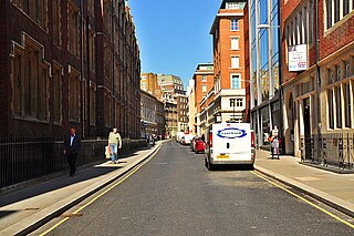
Chancery Lane is a one-way street situated in the ward of Farringdon Without in the City of London. It has formed the western boundary of the City since 1994, having previously been divided between the City of Westminster and the London Borough of Camden. The route originated as a 'new lane' created by the Knights Templar from their original 'old Temple' on the site of the present Southampton Buildings on Holborn, in order to access to their newly acquired property to the south of Fleet Street sometime before 1161.

St George Hanover Square was a civil parish in the metropolitan area of London, England. The creation of the parish accompanied the building of the St George's Hanover Square Church, constructed by the Commission for Building Fifty New Churches to meet the demands of the growing population. The parish was formed in 1724 from part of the quite early medieval parish of Saint Martin in the Fields in the consequent Liberty of Westminster, hundred of Ossulstone and county of Middlesex. It included some of the most fashionable areas of the West End of London, including Belgravia and Mayfair. Civil parish administration, known as a select vestry, was dominated by members of the British nobility until the parish adopted the Vestries Act 1831. The vestry was reformed again in 1855 by the Metropolis Management Act. In 1889 the parish became part of the County of London and the vestry was abolished in 1900, replaced by Westminster City Council. The parish continued to have nominal existence until 1922. As created, it was a parish for both church and civil purposes, but the boundaries of the ecclesiastical parish were adjusted in 1830, 1835 and 1865.
Westminster St James was a civil parish in the metropolitan area of London, England. The creation of the parish followed the building of the Church of St James, Piccadilly in 1684. After several failed attempts, the parish was formed in 1685 from part of the ancient parish of St Martin in the Fields in the Liberty of Westminster and county of Middlesex. It included part of the West End of London, taking in sections of Soho, Mayfair and St James's. Civil parish administration was in the hands of a select vestry until the parish adopted the Vestries Act 1831. The vestry was reformed again in 1855 by the Metropolis Management Act. In 1889 the parish became part of the County of London and the vestry was abolished in 1900, replaced by Westminster City Council. The parish continued to have nominal existence until 1922.
St Clement Danes was a civil parish in the metropolitan area of London, England; an ecclesiastical version remains. The parish was split between the Liberty of Westminster and the Liberty of the Duchy of Lancaster. The area is colloquially split between Aldwych and Adelphi areas associated with the larger Strand area in the extreme east of the City of Westminster. It includes hotels, restaurants, the Indian and Australian High Commissions and the London School of Economics. To its west is Charing Cross station which faces Trafalgar Square.
St Mary le Strand was an ancient parish in the metropolitan area of London, England. It was partly within the Liberty of the Savoy and partly within the Liberty of Westminster. It took its name from the church of St Mary and the Innocents. The church was demolished in 1548 during the construction of Somerset House and not rebuilt until 1723. The parish was de facto merged with the Precinct of the Savoy as "St Mary Savoy", but an attempt to merge the parishes de jure in the early 18th century failed. It was restored as a separate parish following the construction of the New Church in the Strand in 1723. The parish was grouped into the Strand Poor Law Union in 1836 and the Strand District in 1855. In 1889 it became part of the County of London and the Metropolitan Borough of Westminster from 1900. It was abolished as a civil parish in 1922.
St Martin-in-the-Fields was a civil parish in the metropolitan area of London, England. It took its name from the church of St Martin-in-the-Fields and was within the Liberty of Westminster. It included within its boundaries the former extra-parochial areas of Buckingham Palace and St James's Palace.
St Paul Covent Garden was a civil parish in the metropolitan area of London, England. The former area of the parish now corresponds to the Covent Garden market and surrounding streets in the City of Westminster.
The Close of the Collegiate Church of St Peter was an extra-parochial area, and later civil parish, in the metropolitan area of London, England. It corresponded to the area of Westminster Abbey and was an enclave between the parishes of St Margaret and St John, within the City and Liberty of Westminster. The Collegiate Church of St Peter is an alternative name for Westminster Abbey.

Norton Folgate was a liberty in Middlesex, England; adjacent to the City of London in what would become the East End of London.

Stepney was an ancient civil and ecclesiastical parish in the historic county of Middlesex to the east and north east of the City of London, England.

The Liberty of Saffron Hill, Hatton Garden, Ely Rents and Ely Place became a civil parish in the metropolitan area of London, England between 1866 and 1930. It was part of the ancient parish of St Andrew Holborn.