Westminster is the main settlement of the City of Westminster in London, England. It extends from the River Thames to Oxford Street and has many famous landmarks, including the Palace of Westminster, Buckingham Palace, Westminster Abbey, Westminster Cathedral, Trafalgar Square and much of the West End cultural centre including the entertainment precinct of West End Theatre.

The City of Westminster is a city and borough in London. It is the site of the United Kingdom's Houses of Parliament and much of the British government. It occupies a large area of central London, including most of the West End. Many London landmarks are within the borough, including Buckingham Palace, Westminster Abbey, Whitehall, Westminster Cathedral, 10 Downing Street, and Trafalgar Square.

Camberwell was a civil parish and metropolitan borough in south London, England. Camberwell was an ancient parish in the county of Surrey, governed by an administrative vestry from 1674. The parish was included in the area of responsibility of the Metropolitan Board of Works in 1855 and became part of the County of London in 1889. The parish of Camberwell became a metropolitan borough in 1900, following the London Government Act 1899, with the parish vestry replaced by a borough council. In 1965 the borough was abolished and its former area became part of the London Borough of Southwark in Greater London.

Lambeth was a civil parish and metropolitan borough in south London, England. It was an ancient parish in the county of Surrey. The parish was included in the area of responsibility of the Metropolitan Board of Works in 1855 and became part of the County of London in 1889. The parish of Lambeth became a metropolitan borough in 1900, following the London Government Act 1899, with the parish vestry replaced by a borough council.

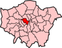
The Metropolitan Borough of Westminster was a metropolitan borough in the County of London, England, from 1900 to 1965.
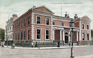
Paddington was a civil parish and metropolitan borough in London, England. It was an ancient parish in the county of Middlesex, governed by an administrative vestry. The parish was included in the area of responsibility of the Metropolitan Board of Works in 1855 and became part of the County of London in 1889. The parish of Paddington became a metropolitan borough in 1900, following the London Government Act 1899, with the parish vestry replaced by a borough council. In 1965 the borough was abolished and its former area became part of the City of Westminster in Greater London.

The Metropolitan Borough of St Marylebone was a metropolitan borough of the County of London from 1900 to 1965. It was based directly on the previously existing civil parish of St Marylebone, Middlesex, which was incorporated into the Metropolitan Board of Works area in 1855, retaining a parish vestry, and then became part of the County of London in 1889.

Hampstead was a civil parish and metropolitan borough in London, England. It was an ancient parish in the county of Middlesex, governed by an administrative vestry. The parish was included in the area of responsibility of the Metropolitan Board of Works in 1855 and became part of the County of London in 1889. The parish of Hampstead became a metropolitan borough in 1900, following the London Government Act 1899, with the parish vestry replaced by a borough council. In 1965 the borough was abolished and its former area became part of the London Borough of Camden in Greater London.

The Metropolitan Borough of Chelsea was a metropolitan borough of the County of London between 1900 and 1965. It was created by the London Government Act 1899 from most of the ancient parish of Chelsea. Following the London Government Act 1963, it was amalgamated with the Royal Borough of Kensington in 1965 to form the Royal Borough of Kensington and Chelsea.
The Metropolitan Borough of Kensington was a metropolitan borough in the County of London from 1900 to 1965, which since 1901 was known as the Royal Borough of Kensington, following the death of Queen Victoria, in accordance with her wishes.

Battersea was a civil parish and metropolitan borough in the County of London, England. In 1965, the borough was abolished and its area combined with parts of the Metropolitan Borough of Wandsworth to form the London Borough of Wandsworth. The borough was administered from Battersea Town Hall on Lavender Hill. That building is now Battersea Arts Centre.

The London Government Act 1899 was an act of the Parliament of the United Kingdom that reformed the administration of the capital. The act divided the County of London into 28 metropolitan boroughs, replacing the 41 parish vestries and district boards of works administering the area. The legislation also transferred a few powers from the London County Council to the boroughs, and removed a number of boundary anomalies. The first elections to the new boroughs were held on 1 November 1900.

The Metropolis Management Act 1855 was an Act of the Parliament of the United Kingdom that created the Metropolitan Board of Works, a London-wide body to co-ordinate the construction of the city's infrastructure. The Act also created a second tier of local government consisting of parish vestries and district boards of works. The Metropolitan Board of Works was the forerunner of the London County Council.

Hackney was a parish in the historic county of Middlesex. The parish church of St John-at-Hackney was built in 1789, replacing the nearby former 16th-century parish church dedicated to St Augustine. The original tower of that church was retained to hold the bells until the new church could be strengthened; the bells were finally removed to the new St John's in 1854. See details of other, more modern, churches within the original parish boundaries below.

The City and Liberty of Westminster was a unit of local government in the county of Middlesex, England. It was located immediately to the west of the City of London. Originally under the control of Westminster Abbey, the local authority for the area was the Westminster Court of Burgesses from 1585 to 1900. The area now forms the southern part of the City of Westminster in Greater London.

St George Hanover Square was a civil parish in the metropolitan area of Westminster, Middlesex, later Greater London, England. The creation of the parish accompanied the building of the Church of St George's, Hanover Square, constructed by the Commission for Building Fifty New Churches to meet the demands of the growing population. The parish was formed in 1724 from part of the ancient parish of St Martin in the Fields in the Liberty of Westminster and county of Middlesex. It included some of the most fashionable areas of the West End, including Belgravia and Mayfair. Civil parish administration, known as a select vestry, was dominated by members of the British nobility until the parish adopted the Vestries Act 1831. The vestry was reformed again in 1855 by the Metropolis Management Act. In 1889 the parish became part of the County of London and the vestry was abolished in 1900, replaced by Westminster City Council. The parish continued to have nominal existence until 1922. As created, it was a parish for both church and civil purposes, but the boundaries of the ecclesiastical parish were adjusted in 1830, 1835 and 1865.
Westminster St James was a civil parish in the metropolitan area of London, England. The creation of the parish followed the building of the Church of St James, Piccadilly, in 1684. After several failed attempts, the parish was formed in 1685 from part of the ancient parish of St Martin in the Fields in the Liberty of Westminster and county of Middlesex. It included part of the West End of London, taking in sections of Soho, Mayfair and St James's. Civil parish administration was in the hands of a select vestry until the parish adopted the Vestries Act 1831. The vestry was reformed again in 1855 by the Metropolis Management Act. In 1889 the parish became part of the County of London and the vestry was abolished in 1900, replaced by Westminster City Council. The parish continued to have nominal existence until 1922.
The Metropolitan Turnpike Trust was the body responsible for maintaining the main roads in the north of the conurbation of London from 1827 to 1872. The commissioners took over from fourteen existing turnpike trusts, and were empowered to levy tolls to meet the costs of road maintenance.
St Martin in the Fields was a civil parish in the county of Middlesex, later part of the new County of London, England. It took its name from the Church of St Martin-in-the-Fields and was within the Liberty of Westminster. Within its boundaries were the former extra-parochial areas of Buckingham Palace and St James's Palace.
St Anne Within the Liberty of Westminster, also known as St Anne Soho, was a civil parish in the county of Middlesex, later part of the new County of London, England.