
The Royal Borough of Greenwich is a London borough in southeast Greater London, England. The London Borough of Greenwich was formed in 1965 by the London Government Act 1963. The new borough covered the former area of the Metropolitan Borough of Greenwich and part of the Metropolitan Borough of Woolwich to the east. The local council is Greenwich London Borough Council which meets in Woolwich Town Hall. The council's offices are also based in Woolwich, the main urban centre in the borough.
West Ham is an area in East London, located 6.1 mi (9.8 km) east of Charing Cross in the west of the modern London Borough of Newham.

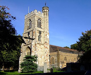
Woolwich is a town in southeast London, England, within the Royal Borough of Greenwich.

The County of London was a county of England from 1889 to 1965, corresponding to the area known today as Inner London. It was created as part of the general introduction of elected county government in England, by way of the Local Government Act 1888. The Act created an administrative County of London, which included within its territory the City of London. However, the City of London and the County of London formed separate ceremonial counties for "non-administrative" purposes. The local authority for the county was the London County Council (LCC), which initially performed only a limited range of functions, but gained further powers during its 76-year existence. The LCC provided very few services within the City of London, where the ancient Corporation monopolised local governance. In 1900, the lower-tier civil parishes and district boards were replaced with 28 new metropolitan boroughs. The territory of the county was 74,903 acres (303.12 km2) in 1961. During its existence, there was a long-term decline in population as more residents moved into the outer suburbs; there were periodic reviews of the local government structures in the greater London area and several failed attempts to expand the boundaries of the county. In 1965, the London Government Act 1963 replaced the county with the much larger Greater London administrative area.

Inner London is the name for the group of London boroughs that form the interior part of Greater London and are surrounded by Outer London. With its origins in the bills of mortality, it became fixed as an area for statistics in 1847 and was used as an area of local government from 1855 to 1965 principally as the County of London or earlier as the Metropolitan Board of Works Area (metropolis). It now has two common definitions. The first is the statutory definition delineated in the London Government Act 1963, coming into force on 1 April 1965, comprising twelve Inner London boroughs and almost identical to the County of London that was abolished at the same time. The second is the definition used by the Office for National Statistics comprising eleven of the statutory Inner London boroughs and two of the statutory Outer London boroughs, as well as the City of London.

The Metropolitan Borough of Woolwich was a metropolitan borough in the County of London from 1900 to 1965. It was formed from the civil parishes of Eltham, Plumstead and Woolwich. Its former area is now part of the Royal Borough of Greenwich and the London Borough of Newham.
North Woolwich is an area in the London Borough of Newham in East London, England, on the northern bank of the River Thames, across the river from Woolwich. It is connected to Woolwich by the Woolwich Ferry and Woolwich foot tunnel.

Beckton is a suburb in east London, England, located 8 miles (12.9 km) east of Charing Cross and part of the London Borough of Newham. Adjacent to the River Thames, the area consisted of unpopulated marshland known as the East Ham Levels in the parishes of Barking, East Ham, West Ham and Woolwich. The development of major industrial infrastructure in the 19th century to support the growing metropolis of London caused an increase in population with housing built in the area for workers of the Beckton Gas Works and Beckton Sewage Treatment Works. The area has a convoluted local government history and has formed part of Greater London since 1965. Between 1981 and 1995 it was within the London Docklands Development Corporation area, which caused the population to increase as new homes were built and the Docklands Light Railway was constructed.

East London is the northeastern part of London, England, east of the ancient City of London and north of the River Thames as it begins to widen. East London developed as London's docklands and the primary industrial centre. The expansion of railways in the 19th century encouraged the eastward expansion of the East End of London and a proliferation of new suburbs. The industrial lands of East London are today an area of regeneration, which are well advanced in places such as Canary Wharf and ongoing elsewhere.

The region of Greater London, including the City of London, is divided into 73 parliamentary constituencies which are sub-classified as borough constituencies, affecting the type of electoral officer and level of expenses permitted.
Greenwich was a constituency in south-east London, which returned at first two, then one member (MP) to the House of Commons of the UK Parliament. It existed from 1832 to 1997. Elections used the first past the post system; when this elects more than one member, it is sometimes called plurality-at-large voting.

West Ham was a local government district in the extreme south west of Essex from 1886 to 1965, forming part of the built-up area of London, although outside the County of London. It was immediately north of the River Thames and east of the River Lea.

Barking was a local government district, and later civil parish and borough, in southwest Essex, England from 1882 to 1965. It was known as Barking Town from 1882 to 1931. The district included the town of Barking, eastern Beckton and the southwestern part of the Becontree estate. The district was within the Metropolitan Police District and experienced a steady increase in population during its existence. It now forms the western part of the London Borough of Barking and Dagenham and the eastern extremity of the London Borough of Newham in Greater London.

The London Government Act 1899 was an act of the Parliament of the United Kingdom that reformed the administration of the capital. The act divided the County of London into 28 metropolitan boroughs, replacing the 41 parish vestries and district boards of works administering the area. The legislation also transferred a few powers from the London County Council to the boroughs, and removed a number of boundary anomalies. The first elections to the new boroughs were held on 1 November 1900.

The Metropolis Management Act 1855 was an Act of the Parliament of the United Kingdom that created the Metropolitan Board of Works, a London-wide body to co-ordinate the construction of the city's infrastructure. The Act also created a second tier of local government consisting of parish vestries and district boards of works. The Metropolitan Board of Works was the forerunner of the London County Council.
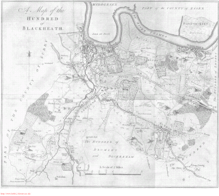
Blackheath was an ancient hundred in the north west of the county of Kent in England. It had become obsolete by the beginning of the 20th century in the wake of ongoing reforms to local government. The name "Blackheath" now refers to a district of SE London. In 2022, the area of the old hundred lies mainly within the Royal Borough of Greenwich.
Plumstead (1855–1894) and then Lee (1894–1900) was a local government district within the metropolitan area of London from 1855 to 1900. It was formed as the Plumstead district by the Metropolis Management Act 1855 and was governed by the Plumstead District Board of Works, which consisted of elected vestrymen.

Deptford St Nicholas was a civil parish in the metropolitan area of London, England. The creation of the parish accompanied the building of the Church of St Paul's, Deptford, constructed by the Commission for Building Fifty New Churches to meet the demands of the growing population. The ancient parish of Deptford was split in 1730 with the southern part around the new church becoming Deptford St Paul. St Nicholas parish included the old maritime settlement and the dockyard adjacent to the River Thames. Civil parish administration was in the hands of the vestry until 1855 when the parish was grouped into the Greenwich District and the parish elected vestrymen to Greenwich District Board of Works. The parish was transferred from the County of Kent to the County of London in 1889. It became part of the Metropolitan Borough of Greenwich in 1900 and the local authority became Greenwich Borough Council. The civil parish had only nominal existence until 1930 when it was abolished. The area became part of the London Borough of Greenwich in 1965 and following boundary changes in 1994, part of the former parish is now in the London Borough of Lewisham.
Woolwich Town Hall is an early 20th-century town hall located in the historic Bathway Quarter in the centre of Woolwich, South East London. Until 1965 it was the seat of local government of the Metropolitan Borough of Woolwich, after which it became the headquarters of the Greenwich London Borough Council. It is a rare example of an Edwardian Baroque town hall in London and is a Grade II*-listed building.

Little and Lesnes was a hundred, a historical land division, in the county of Kent, England. It occupied the northern part of the Lathe of Sutton-at-Hone, within in the west division of Kent. Little and Lesnes was the northernmost hundred in the whole county of Kent. The hundred existed since ancient times, before the Domesday Book of 1086, until it was made obsolete with the creation of new districts at the end of the nineteenth century.

