
Sheringham is an English seaside town within the county of Norfolk, United Kingdom. The motto of the town, granted in 1953 to the Sheringham Urban District Council, is Mare Ditat Pinusque Decorat, Latin for "The sea enriches and the pine adorns".

Beeston is a village in the county of Norfolk, England, in the civil parish of Beeston with Bittering, west of East Dereham and south of Fakenham. It may also be known as Beeston All Saints or Beeston-next-Mileham to distinguish it from the three other villages in Norfolk named Beeston.

Breckland is a local government district in Norfolk, England. Its council is based in Dereham. The district had a population of 130,491 at the 2011 Census.

Sprowston is a small suburban town bordering Norwich in Norfolk, England. It is bounded by Heartsease to the east, Mousehold Heath and the suburb of New Sprowston to the south, Old Catton to the west, and by the open farmland of Beeston St Andrew to the north.
Mitford and Launditch Hundred was an old grouping of parishes for administrative purposes in the County of Norfolk, England. It is located around East Dereham and is bordered by Walsingham Hundred, Aylsham Hundred, Horsham St. Faith Hundred, Forehoe Hundred, Wayland Hundred, Swaffham Hundred and Freebridge Lynn Hundred.
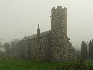
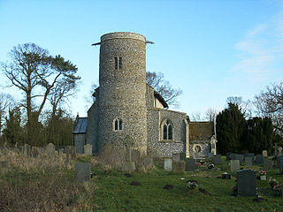
Ashmanhaugh is a village and civil parish in the English county of Norfolk, situated some 20 km north east of Norwich. See Inside the churches of St Swithins here & Beeston St Lawrence here. Apart from Ashmanhaugh village itself, the parish also includes Beeston St Lawrence, which was a separate parish until 1935.
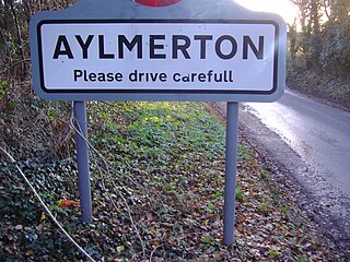
Aylmerton is a village in the county of Norfolk, England. It is in the area of North Norfolk and lies 2.2 miles (3.5 km) south of the North Sea, 3.2 miles (5.1 km) south-west of Cromer and 7.5 miles (12.1 km) east of Holt. The parish is bordered by the parishes of Beeston Regis and Runton to the north, West Beckham to the west, Felbrigg to the east and Gresham and Sustead to the south. The village is ¾ miles south of the A148 King’s Lynn to Cromer road. The nearest railway stations are Cromer at 2.9 miles (4.7 km) and Roughton Road at 4.1 miles (6.6 km). The civil parish has an area of 6.86 square kilometres and in the 2001 census the population was 435 in 178 households, increasing to 458 at the 2011 Census. For the purposes of local government, the parish is in North Norfolk, whose headquarters are in Cromer.

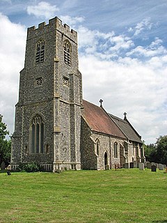
Beeston Regis is a village and civil parish in the North Norfolk district of Norfolk, England. It is about a mile (2 km) east of Sheringham, Norfolk and near the coast. The village is 2 miles (3 km) west of Cromer and 16 miles (26 km) north of the city of Norwich. According to the 2011 census it had a population of 1,062. There is a frequent bus service on the coast road A149 and a rail service from the nearby stations of Sheringham to the west and West Runton to the east, where the Bittern Line runs a frequent service between Norwich, Cromer and Sheringham. The nearest airport is Norwich International Airport.

Beeston St Andrew is a civil parish north of Norwich in the Broadland district of Norfolk, England. It contains Beeston Park and according to the 2001 census had a population of 39. At the 2011 Census the population remained less than 100 and was included in the civil parish of Spixworth.

Beeston with Bittering is a civil parish in the Breckland district of Norfolk, England. According to the 2001 census it had a population of 505, increasing to 566 at the 2011 census. It includes the villages of Beeston and Bittering.

Billingford is a village and civil parish in the Breckland district of Norfolk, England, about 3 1⁄2 miles (5.6 km) north of East Dereham. The village is just north of the River Wensum, which forms the southern boundary of the parish. The village is on the B1145 road, which links King's Lynn and Mundesley. The 2011 Census recorded the parish population as 253.
Burgh and Tuttington is a civil parish in the English county of Norfolk. It covers an area of 6.70 km2 (2.59 sq mi) and had a population of 255 in 115 households at the 2001 census, increasing to a population of 322 in 140 households at the 2011 Census. For the purposes of local government, it falls within the district of Broadland. The parish includes Burgh next Aylsham and Tuttington.
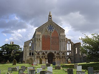
St Mary's Priory, Binham, or Binham Priory, is a ruined Benedictine priory located in the village of Binham in the English county of Norfolk. Today the nave of the much larger priory church has become the Church of St. Mary and the Holy Cross and is still used as a place of worship. The remains of the priory are in the care of English Heritage. The abbey's west face is the first example in England of gothic bar tracery, predating Westminster Abbey by a decade.
Merton is a civil parish in the English county of Norfolk. It covers an area of 5.94 km2 (2.29 sq mi) and had a population of 113 in 50 households at the 2001 census, increasing to a population 0f 133 in 56 households at the 2011 census. For the purposes of local government, it falls within the district of Breckland.
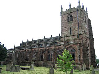
St Boniface's Church stands prominently in the village of Bunbury, Cheshire, England. It is recorded in the National Heritage List for England as a designated Grade I listed building. The church dates mainly from the 14th century. Its features include the Ridley chapel, the alabaster chest tomb of Sir Hugh Calveley and the tomb of Sir George Beeston. Raymond Richards, author of Old Cheshire Churches, considers it is architecturally one of the most important examples of its period in Cheshire. Alec Clifton-Taylor includes it in his list of 'best' English parish churches. It is an active Anglican parish church in the diocese of Chester, the archdeaconry of Chester and the deanery of Malpas. Its benefice is combined with that of St Jude, Tilstone Fearnall.
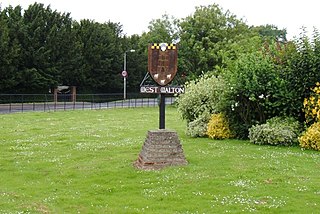
West Walton is a village and civil parish in the King's Lynn and West Norfolk District of Norfolk, England.

Walpole is a civil parish in Norfolk, England. The parish includes the conjoined villages of Walpole St Andrew and Walpole St Peter. Walpole Highway and Walpole Cross Keys are separate civil parishes.

