Fakenham

Last updated

Fakenham
-2019-07-08 War memorial, Market place, Fakenham (2).JPG
Market Place, with the war memorial
Norfolk UK location map.svg
Red pog.svg
Fakenham
Location within Norfolk
Area9.04 km2 (3.49 sq mi)
Population7,617 (2011 census)
  Density 843/km2 (2,180/sq mi)
OS grid reference TF918296
District
Shire county
Region
Country England
Sovereign state United Kingdom
Post town FAKENHAM
Postcode district NR21
Dialling code 01328
Police Norfolk
Fire Norfolk
Ambulance East of England
UK Parliament
List of places
UK
England
Norfolk
52°50′08″N0°51′04″E / 52.8356°N 0.8510°E / 52.8356; 0.8510

Fakenham is a market town and civil parish in Norfolk, England. It is situated on the River Wensum, about 25 miles (40 kilometres) north-west of Norwich. The town is at the junction of several local roads, including the A148 from King's Lynn to Cromer, the A1067 to Norwich and the A1065 to Swaffham.

Contents

The civil parish has an area of 3.49 sq mi (9.0 km2). In the 2001 census, it had a population of 7,357 in 3,292 households; this increased to 7,617 at the 2011 census. [1] For the purposes of local government, the parish lies within the district of North Norfolk. [2]

Fakenham has been a market town since 1250, known particularly for its corn, barley and wheat trading; in the 19th century, it became noted for its printing. Fakenham Racecourse is a thoroughbred horse racing venue to the south of the town.

The town has a long name of Fakenham Lancaster which derives from the ownership of the manor in 1377 being transferred to John of Gaunt, the Duke of Lancaster. The name continues to be used today, including on recently-placed history trail plaques around the town; [3] it is also used to name the town's two wards, for the purpose of electing councillors to North Norfolk District Council: Lancaster North and Lancaster South.

History

The name Fakenham is Saxon and has been interpreted as meaning "homestead of Facca", or "Fair Place"/"Place on a Fair River". Numerous arrowheads and flint tools found in the parish indicate occupation during Neolithic times. Two copper alloy socketed axeheads have been unearthed in Fakenham dated to the Bronze Age. [4] In 2015, a lead plaque was found near Fakenham dating to the Early Medieval period, and has been interpreted as having been used to overcome[ clarification needed ] an illness-causing dwarf based on its runic inscription. [5]

Before 1066 the manor of Fakenham was held by King Harold, before being taken by King William the Conqueror. The manor was relatively large, containing surrounding villages such as Pudding Norton and Thorpland. A number of Early to Late Saxon brooches, buckles, and pottery have been unearthed in the area. A Middle Saxon coin found in the parish is of the East Anglian king Beonna. A watermill was mentioned in Fakenham in the Domesday Book of 1086, but it was later demolished. [4]

In November 1297, Guy Ferre was recorded as the owner of Fakenham Manor, which King Edward I had given to him for life. [6] During the 13th century, the hamlet of Thorpland had 90 parishioners, but by the 16th century it had largely been depopulated, and today all that remains is the hall. [4]

Fires broke out in the town in 1660, 1718 and 1738, which destroyed or partly destroyed a number of buildings. [4] The 4 August 1738 fire destroyed 26 buildings in Fakenham. [7]

Geography

Fakenham is situated in the North Norfolk district, between Pudding Norton and Barsham, on the north bank of the River Wensum. [4] It is sited about 19 mi (31 km) north-east of King's Lynn, 19 mi (31 km) south-west of Cromer and 25 mi (40 km) north-west of Norwich. [8]

To the south-east of Fakenham is Pensthorpe Natural Park, which contains over 700 acres of woodland and lakes, and four gardens. [9]

Economy

Fakenham has been a market town since 1250. Agricultural products and cattle have long been sold at the town's corn and flea markets. [10] John Chambers wrote in his A General History of the County of Norfolk (1829): "Fakenham is a small town, with a good corn market, attended by buyers from Wells, and other contiguous ports. The general market here is on Thursdays, when a large quantity of barley and wheat are sold by samples". [7]

During the 19th century, Fakenham became a major centre for printing, which continued into the 20th century. [10] Fakenham Prepress Solutions is a contemporary printing and illustrating company based in Fakenham. [11] The Kinnerton Confectionery Company was established in the town in 1978. [12]

Landmarks

Saint Peter and Saint Paul Parish Church -2019-07-08 Saint Peter and Saint Paul Parish Church, Oak Street, Fakenham (1).JPG
Saint Peter and Saint Paul Parish Church

Fakenham contains the 14th-century Saint Peter and Saint Paul Parish Church, which replaced an earlier Saxon church. The 115 feet (35 m) tower was built in the 15th century. [13] Baron's Hall was originally built in 1593, but was demolished in 1812 and a new hall opened in 1825. The Corn Exchange opened in 1855, replacing an earlier sessions house. The corn exchange served as the local headquarters for the Home Guard during World War II. [4]

The Star Inn on Oak Street was built in the 17th century. Grove House, The Red Lion, The Wooden Horse and Barclays Bank retain some 17th-century features. [4] The town also contains the Fakenham Museum of Gas and Local History, which displays equipment used for making gas from coal. [10]

Sport

Fakenham Cricket Club is one of the oldest in Norfolk; it started in 1815 with a combined team, including Hempton and Walsingham, and formed in its own right in 1883. The 1st team of the club won the Norfolk Alliance Premier Division league title in 2001, 2011, 2015 and 2018; also the Carter Cup in 2010. [14] Queens Road Recreation Ground is a recreational ground in the centre of Fakenham.

Fakenham Golf Club, on the southern outskirts of the town on the southern side of the Wensum, [15] was originally established in February 1889. [16] The present 6,245 yard course was designed in 1974. [17]

Fakenham Racecourse is a thoroughbred horse racing venue to the south of the town. Charles III is patron. [18] It is the venue for the West Norfolk Hunt's Point to Point steeplechase. [19]

Transport

Railway

The Fakenham Flyer in 1979 WyDFRAC charter at Fakenham 1979.jpg
The Fakenham Flyer in 1979

Fakenham is no longer served by the National Rail network; the nearest stations are at Norwich, King's Lynn and Sheringham. [20]

The town used to have two railway stations:

There was no connection between the two railway lines; the line south of Fakenham West crossed the line from Fakenham East south of the former station, on a girder bridge that still exists immediately north of a three-span bridge over the River Wensum.

When Fakenham East closed to passengers on 5 October 1964, the line remained open for goods. A special passenger service named the Fakenham Flyer ran on 21 April 1979, but this proved to be the only such instance, as the line closed permanently the following year. [21]

Buses

Fakenham is served by several bus routes operated by different companies: [24]

Roads

The town is at the junction of several local roads, including the A148 from King's Lynn to Cromer, the A1067 to Norwich and the A1065 to Swaffham. [25] A single-carriageway bypass was constructed in the mid-1980s to carry the A148 to the north of the town. [26]

Notable people

Notable people from Fakenham include:

Other notable people from the town include footballing brothers Ryan Jarvis and Rossi Jarvis, formerly of Norwich City [27] and Adam Tann, whose League career ended at Chelmsford City and is the cousin of the Jarvis brothers. Another former Norwich City footballer, Matt Gill, grew up in the town and attended the local junior school and high school. [27]

Related Research Articles

<span class="mw-page-title-main">River Wensum</span> River in Norfolk, England

The River Wensum is a chalk river in Norfolk, England and a tributary of the River Yare, despite being the larger of the two rivers. The river is a biological Site of Special Scientific Interest and Special Area of Conservation.

<span class="mw-page-title-main">Dereham</span> Town in Norfolk, England

Dereham, also known historically as East Dereham, is a town and civil parish in the Breckland District of the English county of Norfolk. It is situated on the A47 road, about 15 miles (25 km) west of the city of Norwich and 25 miles (40 km) east of King's Lynn.

<span class="mw-page-title-main">Whissonsett</span> Human settlement in England

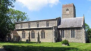
Whissonsett is a village and a civil parish in the English county of Norfolk. The village is 5.0 miles (8.0 km) south of Fakenham, 23 miles (37 km) west-north-west of Norwich and 112 miles (180 km) north-north-east of London. The nearest railway station is at King's Lynn for the Fen Line which runs between King's Lynn and Cambridge. The nearest airport is Norwich International Airport. The parish had in 2001 census, a population of 483 in 206 households, increasing to a population of 488 in 209 households at the 2011 Census. For the purposes of local government, the parish falls within the district of Breckland. The village lies close to the source of the River Wensum.

<span class="mw-page-title-main">Gunthorpe, Norfolk</span> Human settlement in England

Gunthorpe is a village and a civil parish in the English county of Norfolk. The village is 8.6 miles east north east of the town of Fakenham, 14.9 miles west south west of Cromer and 122 miles north north east of London. The nearest railway station is at Sheringham for the Bittern Line which runs between Sheringham, Cromer and Norwich. The nearest airport is Norwich International Airport.

<span class="mw-page-title-main">Twyford, Norfolk</span> Human settlement in England

Twyford is a hamlet and civil parish in the English county of Norfolk. It is situated on the A1067 road, some 12 km (7.5 mi) south-east of the town of Fakenham and 28 km (17 mi) north-west of the city of Norwich.

<span class="mw-page-title-main">Little Snoring</span> Village in Norfolk, England

Little Snoring is a village and a civil parish in Norfolk, England.

<span class="mw-page-title-main">Helhoughton</span> Human settlement in England

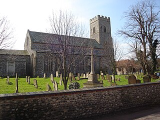
Helhoughton is a village and civil parish in Norfolk, England. It is 4.2 miles (6.8 km) west-south-west of the town of Fakenham, 29.3 miles (47.2 km) west-northwest of Norwich and 112 miles (180 km) north-northeast of London. The nearest railway station is at Sheringham for the Bittern Line which runs between Sheringham, Cromer and Norwich. The nearest airport is Norwich International Airport. The parish had, in the 2001 census, a population of 197, rising to 346 at the 2011 Census. For the purposes of local government, the parish falls within the district of North Norfolk.

<span class="mw-page-title-main">Guestwick</span> Human settlement in England

Guestwick is a village and a civil parish in the English county of Norfolk. The village is 19.6 miles (31.5 km) south-west of Cromer, 18.7 miles (30.1 km) north-west of Norwich and 131 miles (211 km) north-east of London. The village lies 10.2 miles (16.4 km) west of the nearby town of Aylsham. The village lies far from any High roads. The nearest railway station is at Sheringham for the Bittern Line which runs between Sheringham, Cromer and Norwich. The nearest airport is Norwich International Airport.

<span class="mw-page-title-main">A1065 road</span> Road in East Anglia, England

The A1065 is a main road in the English region of East Anglia. It provides the principal road connection to parts of the west and north of the county of Norfolk from Newmarket and points south of there, including London. It runs from a junction near Mildenhall, to a junction on the western outskirt of Fakenham.

<span class="mw-page-title-main">Upper Sheringham</span> Human settlement in England

Upper Sheringham is a village and a civil parish in the English county of Norfolk. The village is 26.8 miles (43.1 km) north-north-west of Norwich, 6 miles (9.7 km) west of Cromer and 132 miles (212 km) north-north-east of London. The village is 1.2 miles (1.9 km) from the town of Sheringham. The nearest railway station is at Sheringham for the Bittern Line which runs between Sheringham, Cromer and Norwich. The nearest airport is Norwich International Airport. Nearby road connections are the A149 King's Lynn to Great Yarmouth road to the north of the village and the A148 King's Lynn to Cromer road just to the south. The parish of Upper Sheringham in the 2001 census, a population of 214, reducing slightly to 209 at the 2011 Census. For the purposes of local government, the parish falls within the district of North Norfolk.

<span class="mw-page-title-main">Bale, Norfolk</span> Village in Norfolk, England

Bale is a village and former civil parish, now in the parish of Gunthorpe, in the North Norfolk district, in the county of Norfolk, England. The village is 9 miles east-north-east of the town of Fakenham, 14.3 miles west-south-west of Cromer and 125 miles north-north-east of London. In 1931, the parish had a population of 208.

<span class="mw-page-title-main">Lenwade</span> Human settlement in England

Lenwade is a village in the civil parish of Great Witchingham, Norfolk, situated in the Wensum Valley adjacent to the A1067 road 14 miles (23 km) south-east of Fakenham and some 11 miles (18 km) north-west of Norwich. The River Ainse joins the Wensum at Lenwade. In 2001 it had a population of 464.

<span class="mw-page-title-main">Hempton</span> Human settlement in England

Hempton is a village and a civil parish in the English county of Norfolk. The village is 0.8 miles (1.3 km) south west of Fakenham, 33.9 miles (54.6 km) north west of Norwich and 100 miles (160 km) north east of London. The village straddles the A1065 between Fakenham and Swaffham. The nearest railway station is at Sheringham for the Bittern Line which runs between Sheringham, Cromer and Norwich. The nearest airport is Norwich International Airport.

<span class="mw-page-title-main">Ryburgh</span> Human settlement in England

Ryburgh is a civil parish in the English county of Norfolk. The parish is 21.2 miles (34.1 km) south-west of Cromer, 23.1 miles (37.2 km) north-west of Norwich and 117 miles (188 km) north-east of London. The parish lies 4 miles (6.4 km) south-east of the nearby town of Fakenham. The nearest railway station is at Sheringham for the Bittern Line which runs between Sheringham, Cromer and Norwich. The nearest airport is Norwich International Airport. The parish includes the villages of Great Ryburgh and Little Ryburgh.

<span class="mw-page-title-main">Barney, Norfolk</span> Human settlement in England

Barney is a village and former civil parish, now in the parish of Fulmodeston, in the North Norfolk district, in the county of Norfolk, England. Settled prior to the Norman Invasion of 1066, the village lies to the south of the A148 King's Lynn to Cromer road near Thursford.The village is 7.2 miles (11.6 km) east north east of the town of Fakenham, 17.1 miles (27.5 km) west south west of Cromer and 121 miles (195 km) north north east of London. The nearest railway station is at Sheringham for the Bittern Line which runs between Sheringham, Cromer and Norwich. The nearest airport is Norwich International Airport. In 1931 the parish had a population of 243.

<span class="mw-page-title-main">2009 Norfolk County Council election</span>

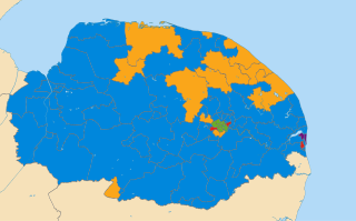
The Norfolk County Council election took place on 4 June 2009, coinciding with local elections for all county councils in England.

The Wymondham to Wells Branch was a railway built in stages by the Norfolk Railway, Eastern Counties Railway and Wells and Fakenham Company between 1847 and 1857. The railway ran from Wymondham in the south, through Dereham and Fakenham to the coastal town of Wells-next-the-Sea; more specifically, the line ran from Wymondham South Junction, where it met the present-day Breckland Line. Passenger services along the line lasted until 1969; the railway continued to be used for freight until 1989. The southern section of the railway now forms the Mid-Norfolk Railway, with part of the northern section serving as the narrow gauge Wells and Walsingham Light Railway.

References

  1. "Town population 2011". Archived from the original on 4 March 2016. Retrieved 1 September 2015.
  2. Office for National Statistics & Norfolk County Council (2001). Census population and household counts for unparished urban areas and all parishes . Retrieved 2 December 2005.
  3. Fakenham Lancaster History Trail The History of Fakenham
  4. 1 2 3 4 5 6 7 "Parish Summary: Fakenham". Norfolk Heritage Explorer. Retrieved 20 February 2020.
  5. Hines, John (2 December 2019). "Practical Runic Literacy in the Late Anglo-Saxon Period: Inscriptions on Lead Sheet". Anglo-Saxon Micro-Texts. De Gruyter. pp. 36–37. doi:10.1515/9783110630961-003. ISBN   978-3-11-063096-1.{{cite book}}: |journal= ignored (help)
  6. Page, William, ed. (1906). The Victoria History of the County of Norfolk. Vol. 2. Constable. p. 382. ISBN   978-0-7129-0646-3.
  7. 1 2 Chambers, John (1829). "A General History of the County of Norfolk". p. 512.
  8. Ordnance Survey (2002). OS Explorer Map 251 – Norfolk Coast Central. ISBN   0-319-21887-2.
  9. "Pensthorpe Natural Park". Visit Norfolk. Retrieved 27 February 2020.
  10. 1 2 3 "Discover Fakenham". Visit North Norfolk. Retrieved 20 February 2020.
  11. "Fakenham Prepress Solutions". Fakprepress.co.uk. Retrieved 27 February 2020.
  12. "About Us". Kinnerton.com. Retrieved 27 February 2020.
  13. "History". fakenhamparishchurch.org.uk. Retrieved 20 February 2020.
  14. "Welcome to Fakenham Cricket Club". fakenhamcricketclub.co.uk. Retrieved 27 February 2020.
  15. Google (27 February 2020). "Fakenham" (Map). Google Maps . Google. Retrieved 27 February 2020.
  16. "Club History". Fakenhamgolfclub.co.uk. Retrieved 27 February 2020.
  17. "Fakenham". Englishgolf-courses.co.uk. Retrieved 27 February 2020.
  18. "Fakenham Racecourse". Princeofwales.gov.uk. Retrieved 27 February 2020.
  19. "West Norfolk Point-to-Point 21st March 2020". Fakenhamracecourse.co.uk. Retrieved 27 February 2020.
  20. "Timetables". Greater Anglia. 10 December 2023. Retrieved 15 January 2024.
  21. 1 2 "Rail group launches bid to buy vital part of former line". East Dereham Times. 1 December 2014. Retrieved 27 February 2020.
  22. Beeching, Richard (27 March 1963). The Reshaping of British Railways – Part 1 (PDF) (Report). Her Majesty's Stationery Office. p. 113.
  23. Armstrong, Chris (2016). Anything From a Pin to an Elephant: Tales of Norfolk Retail. Amberley Publishing Limited. p. 74. ISBN   978-1-445-656533.
  24. "Fakenham – bustimes.org". bustimes.org. Retrieved 18 April 2023.
  25. Fakenham (Sheet 125) (Map). Ordnance Survey. 1964. Retrieved 27 February 2020.
  26. "Roads (Norfolk)". Hansard. 6 November 1984. Retrieved 27 February 2020.
  27. 1 2 "City Signing's Fakenham Link". Dereham Times. Retrieved 10 June 2009.