Thurning is a small dispersed village and civil parish in the English county of Norfolk and district of North Norfolk, near the border with Broadland. The population at the 2011 Census remained less than 100 and is recorded together with the neighbouring civil parish of Hindolveston.
Thurning lies near Corpusty, seven miles (11km) south of Holt, and nine miles (14km) north-west of Aylsham.[2]
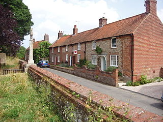
The parish has no substantial settlements and consists chiefly of farms and houses which are well spaced from each other. It includes the small hamlet of Craymere Beck.[3]
In his Topographical Dictionary of England (1848), Samuel Lewis says:[5]
THURNING (St. Andrew)... comprises 1584a. 1r. 19p., of which 1,200 acres (4.9km2) are arable, 300 pasture and meadow, and 80 plantation. The surface is agreeably undulated, and the high grounds command fine views of the picturesque scenery within and around the parish, which is remarkable for the number and variety of wild flowers with which its meadows are studded.
History
At the time of the Domesday Book (1086), Thurning was recorded as 'Tyrninga',[6] i.e. "Tyrnings" (pl.), signifying "the place of the followers or kin-group of Tyrn", typical of the earlier, immigration phase of Angle-Saxon settlements.[7]Charles Parkin translates its findings from the Latin:[8]
The principal lordship of this village was, at the survey, farmed of the Conqueror, or took care of by Godric his steward, Ulf, a Saxon, lord of it in the days of King Edward, being deprived, when one carucate of land and 6 villains, 9 borderers, and one servus belonged to it; there were 2 carucates in demean, one and a half among the tenants, with 10 acres (40,000m2) of meadow, &c., the moiety of a mill, 4 runci, 20 cows, &c., and 50 sheep; and 6 socmen had 16 acres (65,000m2) of land, and a carucate and a half. The soc belonged to the King's manor of Folsham; it was at that time valued at 60s. at the survey at 100s. quit-rent, and 10s. as a present, or free gift, was 5 furlongs long and 6 broad, and paid 5d. to the King's gelt.
In 1659, Peter Elwin of Thurning (1623–1695) married Anne Rolfe, the elder daughter of Anthony Rolfe, of Tuttington
Parish registers survive only from the early 18th century. Registers deposited in the Norfolk Record Office are for baptisms (1707, 1715–2006), marriages (1717–1739, 1758–2004), burials (1716–2006) and banns (1758–1822). However, some Archdeacons' and Bishops' transcripts survive, copies of register entries for years as far back as 1600.[9]
According to William White, a good new rectory was built in 1827.[10] Samuel Lewis calls this "a handsome house erected in 1832".[5]
William White's History, Gazetteer, and Directory of Norfolk (1835 edition) says of Thurning:[12]
THURNING, or Thirning, is a parish of dispersed houses, 6 miles (9.7km) S. of Holt, and 4½ miles N. of Reepham, with 140 inhabitants and about 1,500 acres (6.1km2) of land. W. E. L. Bulwer, Esq., is lord of the manor, (fine arbitrary.) A great part of the soil belongs to Hastings Elwyn, Esq., the owner of Thurning Hall, a neat mansion, with a fine lawn and small lake, and now the residence of James Gay, Esq. Mr. J. R. Barber, J. Richardson, Esq., and some others, have estates here. CRIMER'S BECK gives name to a hamlet on the north side of the parish. The CHURCH, dedicated to St. Andrew, has a nave, north aisle, and tower, with three bells, and had formerly a chancel. It was new roofed about ten years ago. The rectory, valued in K. B. at £7, is in the gift of Christ College, Cambridge, and incumbency of the Rev. Henry Wm. Blake, whose residence was rebuilt about four years ago. Directory - Thos. Frost, vict., Plough; James Gay, Esq.; Thos. Paul, shopkeeper; Hy. Pointin, blacksmith; Wm. Reynolds, miller; Samuel Rider, shoemaker; and Jas. Rech Barber, Richard Harvey, James Margarson, John Pye, John Sewell and Daniel Sidney, farmers.
In 1835, there were twelve parliamentary electors for the West Norfolk division in respect of Thurning, of whom four were outside the parish: Thomas Armes of Weybourne, Hastings Elwin, Esq., of Thorpe, Caleb Elwin, clerk, of Melton Constable, and Robert Fountain Elwin, clerk, of Norwich. The eight at Thurning itself were Henry Wm Blake, clerk, Rash James Barber, James Gay, Esq., of Thurning Hall, Richard Hervey, James Margarson, John Pye, Daniel Sidney, and John Sewell.[13]
In 1836, Thomas Frost was the licensee of a public house called 'The Plough'.[14]
William White's History, Gazetteer, and Directory of Norfolk (second edition, 1845) says of Thurning:[15]
THURNING, or Thirning, is a parish of scattered houses, 6 miles (9.7km) S. of Holt, and 4½ miles N. of Reepham, containing 166 souls and 1594 A. 1 R. 19 P. of land. W. E. L. Bulwer, Esq., is lord of the manor, but a great part of the soil belongs to Lord Hastings, J. Richardson, Esq., and James Gay, Esq. The latter is seated at the Hall, a neat mansion, with a fine lawn and small lake. CRIMES BECK gives name to a small hamlet, on the north side of the parish. The Church, St. Andrew, was new roofed about 18 years ago. The rectory, valued in K. B. at £7, has 18 acres (73,000m2) of glebe, a good residence, rebuilt in 1832, and a yearly rent of £370, awarded in 1839, in lieu of tithes. The patronage is in Christ College, Cambridge, and the Rev. Henry Wm. Blake is the incumbent. The other residents are, Maria Eke, shopkeeper; James Gay, Esq., Hall; Henry Pointin, blacksmith; Wm. Reynolds, miller; Samuel Rider, shopkeeper; and Jas. Rash Barber, James Bidwell, Daniel Fransham, Wm. Laskey, John Pye, and Wm. Rix, farmers.
In 1883, the chief crops were wheat, roots, barley and hay.[4] Lieutenant-Colonel W. E. G. L. Bulwer was the lord of the manor.[10] The principal residents were listed as Jas. Gay Esq. J.P., Thurning hall, Rev. John Fenwick, B.D., J.P., rector, Robert Brownsell, William Brownsell, Frederick Faircloth, Henry Hall, and Alfred Clark of Wood Dalling, farmers, George Burton, gamekeeper, William Harvey, farm bailiff, and Edwd. Poynton of Cray mere, blacksmith.[10]
At the census of 1891, the following surnames are recorded in the parish: Adams, Aldis, Allen, Barnes, Baxter, Breeze, Brownell, Clitheroe, Cottrell, Cozens, Faircloth, Frances, Frost, Gay, Girling, Hall, Hardingham, Hazelwood, Hipkin, Howell, Hubbert, Keeler, Knowles, Ladell, Lease, Meadows, Partridge, Plane, Plattan, Poynton, Ray, Scarff, Sexton, Shave, Shuton, Southgate, Strutt, Twiddy, and Wright.[17]
In 1900, the parish priest was the Rev. Robert Rust Meadows,[18] while the parish clerk was Robert Ladell.[19]
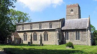
St Andrew's Parish Church
St Andrew's, Thurning, looks at first sight like a typical medieval church. Open every day,[20] it stands alone, isolated from other buildings, on the Reepham Road and about a quarter of a mile north of The Rectory.[3] Nearby is the former stable of the Rector, who sometimes lived at Wood Dalling. The church lacks a chancel, this having been demolished early in the 18th century. The east window has cross-linkedtracery, clearly used to fill the arch of the lost chancel, and the east end of the north aisle has an unusual rectangular window.[21]
In 1823, the church gained the furnishings of the old chapel of Corpus Christi College, Cambridge, when that was demolished. The aisle and the west end are filled with 18th-century box pews, and the interior is dominated by a huge three-deck pulpit at the east end of the church, designed by James Burrough. On each of the box pews, a sign gives the name of the property in the parish which paid rent for it. The middle of the church contains plain benches, the sanctuary has communion rails, and the south wall a line of hat pegs. Also on the south wall and in the sanctuary are several 18th century memorials.[20][21]
About 1833, the building was thoroughly restored.[10]
The church of St. Andrew is a building of flint in the Perpendicular style and has chancel, nave, north aisle and square tower containing 1 bell. The register dates from the year 1715. The living is a rectory, tithe rent charge £370 with 23 acres (93,000m2) of glebe and residence, in the gift of the Master and fellows of Corpus Christi college, Cambridge, and held since 1858 by the Rev. John Fenwick B.D. late fellow and tutor of that college, J.P. Norfolk.
Thurning now forms part of the Church of England 'Reepham and Wensum Valley Team of Churches' benefice, which also has churches at Reepham, Salle, Wood Dalling, Bylaugh, Elsing Lyng, Sparham, Swannington, Weston Longville, Attlebridge, Alderford and Great & Little Witchingham.
Thurning Hall
Thurning Hall is an 18th-century grade II listed country house with a walled garden, set in 40 acres (160,000m2) and surrounded by woodland. A large square three-storey Georgian building, it remains a private house but can be hired for weddings.[22][23]
Shortly after the present house was built, it was advertised to let:[24]
To be Lett from Year to Year, and entered upon immediately, a genteel modern built Brick House, pleasantly situated at Thurning, in Norfolk; consisting of a neat Vestibule and Stair-Case, two good Parlours, wainscotted, small Study, six Bed-chambers, Closets, Servants Garret, Kitchen, and all convenient Offices necessary for a small Family. - There is a very good Six-stall'd Stable, with a roomy Hay-chamber, Coach-house, Dogs-kennels, with a Granary over the same, small Garden, spacious Court Yard, Plantations, handsome Waters, well stocked with Carp and Tench; contiguous to the House are 5 acres (20,000m2) of rich Meadow and Pasture Land to be lett with the same, part of which (adjoining to the Stable) is inclosed with a new Paling towards the Road. - The House has been largely put into exceeding good Repair; Coppers, Kitchen Range, Jack, Bath and other Stoves, are already fixed for the Convenience of a Tenant. Note. William Wright, Gardener at the House, will shew the Premisses. - For further Particulars enquire of Peter ELWIN, of Booton, Esq. N.B. Carriers to and from Norwich pass by the House weekly.
The Hall, the seat of James Gay esq jun. B.A., D.L., J.P. is a mansion which stands upon rising ground, surrounded by trees: the river Thurn, which flows through the park, expands into a lake within it: the view from the front of the Hall is very fine. Some curious flint hatchet-heads and some Druidical remains have been dug up in the grounds of the Hall.
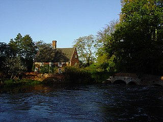
During the first quarter of the 19th century, Thurning Tower Windmill worked closely with Thurning Water-mill. From auction particulars of 1826, it appears that each mill powered two sets of stones. Bryant's map (1826) shows the windmill immediately to the north of the water-mill and marks them together as 'Union Mills', which infers that they worked together.[26]
A notice for an auction at the Black Boys Inn, Aylsham, to be held on 14 August 1826 advertised the sale of "Lot 2. A Water Corn Mill & Wind Mill, lately erected on the most improved construction & containing four pairs of stones & two flour dressers, with stable, cowhouse & other outhouses & 27 acres (110,000m2) or thereabouts of Arable land, meadow, wood & ozier ground adjoining. Also a Messuage & garden at a short distance from the Mill. The buildings & part of the lands in this Lot are in the occupation of William Reynolds, tenant from year to year & Possession of the remainder may be had at Michaelmas next."[26][27]
In 1861, the notice of another auction to be held on 26 July 1861 advertised the sale of: "In BRISTON & THURNING Lot 2. A Messuage or Dwelling House with productive Garden adjoining, Watermill driving two pairs of stones, with large waterwheel in good repair & plentiful supply of water, Windmill, Cart Lodge, & other Outbuildings together with 30a. 1r. 19p. of Arable & Pasture LAND adjoining in the occupation of Chester Leman. This lot abuts upon Briston Common & land of James Gay, Esq. The Mills are capable of doing an extensive & lucrative business. Freehold."[26][28]
Related Research Articles
The Marriott's Way is a footpath, cycle-path and bridleway in north Norfolk, England, between Norwich and Aylsham via Themelthorpe. It forms part of the National Cycle Network (NCN) and the red route of Norwich's Pedalways cycle path network. It is open to walkers, cyclists and horse riders. Its total length is 24.6 miles (39.5 km). It has a mixture of surfaces: tarmac, compacted gravel and earth. The name of the route originates from the chief engineer and manager of the Midland and Great Northern Joint Railway (M&GNJR), William Marriott, who held the position for 41 years.
Aylsham is a historic market town and civil parish on the River Bure in north Norfolk, England, nearly 9 mi (14 km) north of Norwich. The river rises near Melton Constable, 11 miles (18 km) upstream from Aylsham and continues to Great Yarmouth and the North Sea, although it was only made navigable after 1779, allowing grain, coal and timber to be brought up river.
Whissonsett is a village and a civil parish in the English county of Norfolk. The village is 5.0 miles (8.0 km) south of Fakenham, 23 miles (37 km) west-north-west of Norwich and 112 miles (180 km) north-north-east of London. The nearest railway station is at King's Lynn for the Fen Line which runs between King's Lynn and Cambridge. The nearest airport is Norwich International Airport. The parish had in 2001 census, a population of 483 in 206 households, increasing to a population of 488 in 209 households at the 2011 Census. For the purposes of local government, the parish falls within the district of Breckland. The village lies close to the source of the River Wensum.
Bawdeswell is a small rural village and civil parish in Norfolk, England. At the time of the 2011 census it had a population of 828 and an area of 487 hectares. The village is situated almost in the centre of Norfolk about 14 miles (23 km) northwest of Norwich. For the purposes of local government it falls within the Upper Wensum Ward of Breckland District Council and the Elmham and Mattishall Division of Norfolk County Council. It is on a Roman road that ran east–west between Durobrivae near modern Peterborough and Smallburgh, crossing the Fen Causeway.
Booton is a village and civil parish in the Broadland district of Norfolk, England, just east of Reepham and seven miles west of Aylsham. According to the 2001 census, it had a population of 100, including Brandiston and increasing to 196 at the 2011 Census.
Lyng is a village and civil parish in the English county of Norfolk. It is situated on the River Wensum, some 10 km (6.2 mi) north-east of the town of East Dereham and 20 km (12 mi) north-west of the city of Norwich.
Great Snoring is a rural village in North Norfolk by the River Stiffkey, in the east of England. It is situated approximately 25 miles (40 km) north-west from the city and county town of Norwich, and 2 miles (3 km) north from the larger village of Little Snoring.
Reepham is a market town and civil parish in the Broadland district of Norfolk, England. Reepham is situated on the B1145 road between the Bure and Wensum valleys. The town is 12 miles (19 km) northwest of Norwich. At the time of the 2001 census the civil parish had a population of 2,455 residents in 970 households, occupying an area of 1,909 hectares. increasing to a population of 2,709 in 1,169 households at the 2011 census.
Hevingham is a village and civil parish in the Broadland district of the English county of Norfolk. Situated between the A140 road Norwich to Cromer road and the B1149 road Norwich to Holt road. It is 7 miles (11 km) north from the city of Norwich and 4 miles (6.4 km) south from the market town of Aylsham.
Helhoughton is a village and civil parish in Norfolk, England. It is 4.2 miles (6.8 km) west-south-west of the town of Fakenham, 29.3 miles (47.2 km) west-northwest of Norwich and 112 miles (180 km) north-northeast of London. The nearest railway station is at Sheringham for the Bittern Line which runs between Sheringham, Cromer and Norwich. The nearest airport is Norwich International Airport. The parish had, in the 2001 census, a population of 197, rising to 346 at the 2011 Census. For the purposes of local government, the parish falls within the district of North Norfolk.
Guestwick is a village and a civil parish in the English county of Norfolk. The village is 19.6 miles (31.5 km) south-west of Cromer, 18.7 miles (30.1 km) north-west of Norwich and 131 miles (211 km) north-east of London. The village lies 10.2 miles (16.4 km) west of the nearby town of Aylsham. The village lies far from any High roads. The nearest railway station is at Sheringham for the Bittern Line which runs between Sheringham, Cromer and Norwich. The nearest airport is Norwich International Airport.
Lamas is a village in Broadland, Norfolk, England. Administratively it falls within the civil parish of Buxton with Lamas.
Honing is a village and a civil parish in the English county of Norfolk. The village is 15 miles (24 km) north-northeast of Norwich, 13 miles (21 km) south east of Cromer and 4 miles (6.4 km) east of North Walsham.
Brandiston is a small village and civil parish near the centre of the county of Norfolk, England, about two miles south-east of the small market town of Reepham, five miles south-west of the larger town of Aylsham and 10 miles north-west of the city of Norwich. For the purposes of local government, it falls within Broadland district. The hamlet of Guton lies within the parish.
Gissing is a village and civil parish in Norfolk, England, about 6 miles (9.7 km) north of Diss and 15 miles (24 km) south-west of Norwich.
Crostwight is a small village and former civil parish, now in the parish of Honing, in the North Norfolk district, in the north-east of the county of Norfolk, England. In the past, it was sometimes called Crostwick, but this should be avoided, for fear of confusion with the different village of Crostwick, also in Norfolk. In 1931 the parish had a population of 61.
Newton by Castle Acre is a village and civil parish in the Breckland district of the English county of Norfolk. It is situated on the A1065 Mildenhall to Fakenham road, about 4 miles (6.4 km) north of the town of Swaffham. The village is 28 miles (45 km) from the city of Norwich and 103 miles (166 km) from London.
Pettywell is a hamlet within the a civil parish of Reepham in the English county of Norfolk. The hamlet is 8.3 miles (13.4 km) west south west of Aylsham and 14.7 miles (23.7 km) north west of Norwich and 128 miles (206 km) north east of London. The hamlet is on the north side of the B1145 which links King's Lynn and Mundesley. The nearest railway station is at North Walsham for the Bittern Line which runs between Sheringham, Cromer and Norwich.The nearest airport is at Norwich International Airport. For the purposes of local government, the parish of Reepham falls within the district of Broadland.
Marsham is a village and civil parish in the English county of Norfolk, about 10 miles (16 km) north of Norwich. It covers an area of 7.40 km2 (2.86 sq mi) and had a population of 674 in 282 households at the 2001 census.
Calthorpe is a small village and former civil parish, now in the parish of Erpingham, in the North Norfolk district, in the county of Norfolk, England. The village is located 0.5 miles (0.80 km) west of the village of Erpingham, 3.4 miles (5.5 km) north of the nearest town of Aylsham and is 15.8 miles (25.4 km) north of the nearest city of Norwich. The nearest railway station is at Gunton for the Bittern Line which runs between Sheringham, Cromer and Norwich and is 7.8 miles (12.6 km) from the village. The nearest airport is Norwich International 14.2 miles (22.9 km) south of the village. In 1931 the parish had a population of 143.
↑ Parkin, Charles, An Essay Towards a Topographical History of the County of Norfolk, vol. VIII (London: William Miller, 1808) pp. 279–282 at books.google.co.uk. Retrieved 18 July 2008.
↑ White, William, History, Gazetteer, and Directory of Norfolk, and the City and County of the City of Norwich (Sheffield, Wm. White, 1835) p. 358.
↑ The Poll for Two Knights of the Shire for the Western Division of the County of Norfolk, taken on the 15th and 16th of January, 1835, with the entire Register of the Electors (Norwich: Matchett, Stevenson & Matchett, 1835), p. 81.
↑ White, William, History, Gazetteer, and Directory of Norfolk, and the City and County of the City of Norwich (Sheffield, Wm. White, 2nd edition, 1845) p. 358.
↑ Clarke, Benjamin, The British Gazetteer, Political, Commercial, Ecclesiastical, and Historical: Volume III L-Z (London, H. G. Collins, 1852), p. 765.
This page is based on this Wikipedia article Text is available under the CC BY-SA 4.0 license; additional terms may apply. Images, videos and audio are available under their respective licenses.