
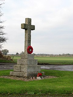
Reedham is a village and civil parish in the English county of Norfolk and within The Broads. It is on the north bank of the River Yare, some 12 miles (19 km) east of the city of Norwich, 7.5 mi (12.1 km) south-west of the town of Great Yarmouth and the same distance north-west of the Suffolk town of Lowestoft.

Neatishead is a village and civil parish in the English county of Norfolk. The village is situated some 20 km (12 mi) north-east of the city of Norwich, within The Norfolk Broads and to the west of Barton Broad. Access to Neatishead from the broad is by way of Limekiln Dyke, a narrow channel leading off the broad.

Titchwell is a village and civil parish in Norfolk, England. It is situated on the north Norfolk coast some 2 km (1.2 mi) west of the village of Brancaster, 9 km (5.6 mi) north-east of the seaside resort of Hunstanton, 30 km (19 mi) north of the town of King's Lynn and 70 km (43 mi) north-west of the city of Norwich.

South Creake is a village and civil parish in north west Norfolk, England. The village lies 1+1⁄2 miles (2.4 km) south of its twin village of North Creake, and some 5 miles (8 km) north-west of the town of Fakenham.

Bawsey is a village and civil parish in the English county of Norfolk. The village is about 4 miles (6.4 km) east of the town of King's Lynn and 40 miles (64 km) west of the city of Norwich. The village sits astride of the B1145 Kings Lynn to Mundesley road that dissects North Norfolk west to east.
Scottow is a village and civil parish in the English county of Norfolk. It is located some 2.5 miles north of Coltishall and 5 miles south of North Walsham.

Bradenham is a village and civil parish, a conglomeration of East and West Bradenham, in the English county of Norfolk. It is situated some 5 miles (8.0 km) south-west of the town of East Dereham and 19 miles (31 km) west of the city of Norwich. The civil parish has an area of 16.55 km2 and in the 2001 census had a population of 722 in 301 households, the population decreasing to 700 in 293 households at the 2011 Census. For the purposes of local government, the parish falls within the Breckland district.

Ingworth is a village and a civil parish in the English county of Norfolk. the nearest town is Aylsham which is 1.7 miles (2.7 km) south of the village. The village is 14.3 miles (23.0 km) north of Norwich, 7.3 miles (11.7 km) east of North Walsham and 9 miles (14 km) south-southwest of Cromer on the north Norfolk coast. The nearest railway station is at North Walsham Railway station where the Bittern Line from Cromer to Norwich can be accessed and the national rail network beyond. The nearest airport is Norwich International Airport. The village lies a 0.9 miles (1.4 km) east of the A140 Cromer to Norwich road. The Village and parish of Ingworth had in the 2001 census, a population of 94. For the purposes of local government, the Hamlet falls within the district of North Norfolk. The population taken at the 2011 Census remained less than 100 and was included in the civil parish of Erpingham.

Wreningham is a village and civil parish in the English county of Norfolk. It is situated some 3 miles (4.8 km) south east of Wymondham and 9 miles (14 km) south west of Norwich.

Wramplingham is a village and civil parish in the English county of Norfolk. It is situated on the River Tiffey some 4 miles (6.4 km) north of Wymondham and 7 miles (11 km) west of Norwich. The civil parish has an area of 3.47 square kilometres and in 2001 had a population of 110 in 44 households, increasing to a population of 115 in 51 households at the 2011 Census. For the purposes of local government, the parish falls within the district of South Norfolk.

Ingoldisthorpe is a village and civil parish in the north-west of the English county of Norfolk. It is located approximately 9 miles (14 km) north-east of the town King's Lynn and 37 miles (60 km) from the county town of Norwich.

Woodton is a village and civil parish in the English county of Norfolk. It is situated some 7 km north-west of the Suffolk town of Bungay, and 20 km south-east of Norwich.

Repps with Bastwick is a civil parish in the English county of Norfolk. It comprises the adjacent villages of Bastwick and Repps, which are situated some 16 km (9.9 mi) north-west of the town of Great Yarmouth and 22 km (14 mi) north-east of the city of Norwich. The parish borders the River Thurne and Bastwick is at the south end of the bridge which carries the A149 road over that river to the village of Potter Heigham.

Thornham is a village and civil parish in the English county of Norfolk. It is situated on the north Norfolk coast some 7 kilometres (4.3 mi) north-east of the seaside resort of Hunstanton, 30 km (19 mi) north of the town of King's Lynn and 70 km (43 mi) north-west of the city of Norwich.
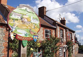
Warham is a village and civil parish in the English county of Norfolk. It is situated about 5 km (3.1 mi) inland from the north Norfolk coast, 5 km (3.1 mi) south-east of the town of Wells-next-the-Sea and 50 km (31 mi) north-west of the city of Norwich.

East Barsham is a village within the civil parish of Barsham in the English county of Norfolk.

West Barsham is a village within the civil parish of Barsham which is in the English county of Norfolk.

North Barsham is a village within the civil parish of Barsham in the English county of Norfolk.

Houghton Saint Giles is a village within the civil parish of Barsham in the English county of Norfolk. It has also been referred to as Houghton-le-Dale or Houghton-in-the-Hole.

Elsing is a village and civil parish in the English county of Norfolk. The village is approximately 5 miles (8 km) miles north-east of the town of East Dereham and 12 miles (19 km) north-west of the city of Norwich. The nearest village is Lyng, 1 mile (1.6 km) to the north-east.
