
Brumstead is a village and a civil parish in the English county of Norfolk. The village is 15.3 miles (24.6 km) north-east of Norwich, 17.6 miles (28.3 km) south-south-east of Cromer and 134 miles (216 km) north-east of London. The village lies 1.2 miles (1.9 km) north of the town of Stalham.

Bodham is a civil parish in the English county of Norfolk. The village is 27.2 miles north north west of Norwich, 6.4 miles west of Cromer and 131 miles north north east of London. The village lies 3.1 miles south west of the nearest town of Sheringham.The nearest railway station is at Sheringham for the Bittern Line which runs between Cromer and Norwich. The nearest airport is Norwich International Airport. The village is situated on the A148 coast road which links the town of King's Lynn to Cromer. The civil parish had in 2001 census, a population of 435, increasing to 484 at the 2011 Census. For the purposes of local government, the parish falls within the district of North Norfolk.

Gunthorpe is a village and a civil parish in the English county of Norfolk. The village is 8.6 miles east north east of the town of Fakenham, 14.9 miles west south west of Cromer and 122 miles north north east of London. The nearest railway station is at Sheringham for the Bittern Line which runs between Sheringham, Cromer and Norwich. The nearest airport is Norwich International Airport.

Letheringsett with Glandford is a civil parish in the English county of Norfolk. It includes the village of Letheringsett, along with the hamlet of Glandford. The village straddles the A148 King's Lynn to Cromer road. Letheringsett is 1.2 miles west of Holt, 32.2 west north east of King's Lynn and 126 miles north north east of London. The nearest railway station is at Sheringham for the Bittern Line which runs between Sheringham, Cromer and Norwich. The nearest airport is Norwich International Airport.

Briningham is a village and a civil parish in the English county of Norfolk. The village is 9.9 miles east north east of the town of Fakenham, 13.3 miles west south west of Cromer, 22.3 miles north north west of the city of Norwich, and 124 miles north north east of London.

Briston is a village, civil parish and electoral ward in the English county of Norfolk that contains the hamlet of Briston Common. The village is 11 miles (18 km) east north east of the town of Fakenham, 13.3 miles (21.4 km) west south west of Cromer, 20.3 miles (32.7 km) north north west of the city of Norwich, and 125 miles (201 km) north north east of London. The village is situated on the route of the B1354 that runs between the A148 at Thursford and the B1149 at Saxthorpe.

Little Snoring is a village and a civil parish in Norfolk, England.

Plumstead is a village and a civil parish in the English county of Norfolk. The village is 19.7 miles (31.7 km) north north west of Norwich, 9.5 miles (15.3 km) south-west of Cromer and 134 miles (216 km) north-east of London. The nearest town is Holt which is 4.8 miles (7.7 km) to the north west of the village. The nearest railway station is in the town of Sheringham where access to the national rail network can be made via the Bittern Line to Norwich. The nearest airport is Norwich International Airport. Plumstead falls within the area covered by North Norfolk District Council.

Edgefield is a village and a civil parish in the English county of Norfolk. The village is located 3.3 miles (5.3 km) south of Holt, 3.3 miles (5.3 km) north-east of Melton Constable and 18 miles (29 km) of Norwich.
Roughton is a village and a civil parish in the English county of Norfolk. The village is 3.7 miles (6.0 km) south of Cromer, 19.6 miles (31.5 km) north of Norwich, and 6.5 miles (10.5 km) north-west of North Walsham. It straddles the A140 between Cromer and Norwich and the B1463.

Fulmodeston or Fulmodeston-cum-Croxton is a village and civil parish in the English county of Norfolk. The village is located 4 miles (6.4 km) south-east of Fakenham and 20 miles (32 km) north-west of Norwich, along the course of River Stiffkey. Fulmodeston parish also includes the small villages of Barney.
Upper Sheringham is a village and a civil parish in the English county of Norfolk. The village is 26.8 miles (43.1 km) north-north-west of Norwich, 6 miles (9.7 km) west of Cromer and 132 miles (212 km) north-north-east of London. The village is 1.2 miles (1.9 km) from the town of Sheringham.
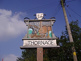
Thornage is a village and a civil parish in the English county of Norfolk. The village is 2.7 miles south-west of Holt, 23.2 miles north-west of Norwich and 11.3 miles east of Fakenham, and straddles the B1110 road between Holt and Guist. The nearest railway station is at Sheringham for the Bittern Line which runs between Sheringham, Cromer and Norwich. The nearest airport is at Norwich International Airport.

Little Barningham is a village and a civil parish in the English county of Norfolk. The village is 19 miles (31 km) north of Norwich, 10 miles (16 km) south-west of Cromer and 133 miles (214 km) north-east of London. The nearest railway station is in the town of Sheringham where access to the national rail network can be made via the Bittern Line to Norwich. The nearest airport is Norwich International Airport. Little Barningham is within the area covered by North Norfolk District Council.
Hempton is a village and a civil parish in the English county of Norfolk. The village is 0.8 miles (1.3 km) south west of Fakenham, 33.9 miles (54.6 km) north west of Norwich and 100 miles (160 km) north east of London. The village straddles the A1065 between Fakenham and Swaffham. The nearest railway station is at Sheringham for the Bittern Line which runs between Sheringham, Cromer and Norwich. The nearest airport is Norwich International Airport.

Cockthorpe is a village and former civil parish, now in the parish of Binham, in the North Norfolk district, in the county of Norfolk, England. It is 5.2 miles (8.4 km) north-west of Holt, 28.9 miles (46.5 km) north-west of Norwich and 127 miles (204 km) north of London. In 1931 the parish had a population of 55. On 1 April 1935 the parish was abolished and merged with Binham.

Stibbard is a village and civil parish in the English county of Norfolk. The village is 19.3 miles (31.1 km) south-west of Cromer, 21.2 miles (34.1 km) north-west of Norwich and 120 mi (190 km) north-east of London. The village lies 4.9 miles (7.9 km) south-east of the nearby town of Fakenham. The nearest railway station is at Sheringham for the Bittern Line which runs between Sheringham, Cromer and Norwich. The nearest airport is Norwich International Airport.

Sharrington is a village and former civil parish, now in the parish of Brinton, in the North Norfolk district, in the county of Norfolk, England. The village is laid out on the southern edge of the A148, 3.5 miles west of Holt. The village is 10 miles east-northeast of the town of Fakenham, 13.4 miles west-southwest of Cromer and 124 miles north-northeast of London. The nearest railway station is at Sheringham for the Bittern Line which runs between Sheringham, Cromer and Norwich. The nearest airport is at Norwich. In 1931 the parish had a population of 195. On 1 April 1935 the parish was abolished and merged with Brinton.

Bradfield is a village and former civil parish, now in the parish of Swafield, in the North Norfolk district, in the county of Norfolk, England. The village is 7.6 miles (12.2 km) south south east of Cromer, 18.1 miles (29.1 km) north north east of Norwich and 135 miles (217 km) north east of London. The village lies 3.1 miles (5.0 km) north north west of the town of North Walsham. In 1931 the parish had a population of 136.

Hunworth is a village and former civil parish, now in the parish of Stody, in the North Norfolk district, in the county of Norfolk, England. The village is 11.5 miles (18.5 km) east-north-east of the town of Fakenham, 12.6 miles (20.3 km) west-south-west of Cromer and 125 miles (201 km) north-north-east of London. The nearest town is Holt which lies 3.4 miles (5.5 km) north of the village. The nearest railway station is at Sheringham for the Bittern Line which runs between Sheringham, Cromer and Norwich. The nearest airport is Norwich International Airport. The village is situated on the road between Holt and Briston. In 1931 the parish had a population of 173.

