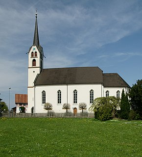
Bizau

Last updated

Bizau
G Bizau.JPG
Wappen at bizau.png
Coat of arms
Bizau im Bezirk B.png
Location in the district
Austria adm location map.svg
Red pog.svg
Bizau
Location within Austria
Coordinates: 47°22′08″N09°55′24″E / 47.36889°N 9.92333°E / 47.36889; 9.92333 Coordinates: 47°22′08″N09°55′24″E / 47.36889°N 9.92333°E / 47.36889; 9.92333
Country Austria
State Vorarlberg
District Bregenz
Government
   Mayor Josef Moosbrugger (ÖVP)
Area
[1]
  Total21.08 km2 (8.14 sq mi)
Elevation
681 m (2,234 ft)
Population
 (2018-01-01) [2]
  Total1,107
  Density53/km2 (140/sq mi)
Time zone UTC+1 (CET)
  Summer (DST) UTC+2 (CEST)
Postal code
6874
Area code 05514
Vehicle registration B
Website www.bizau.co.at

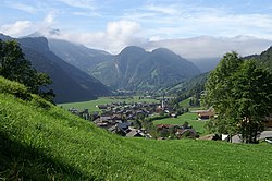
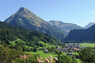
Bizau is a town in the Bregenz Forest in the Austrian state of Vorarlberg, part of the district Bregenz. The municipality has around 1080 inhabitants.

Bregenz Forest Region in Vorarlberg, Austria

The Bregenz Forest is one of the main regions in the state of Vorarlberg, Austria. It overlaps, but is not conterminous with, the Bregenz Forest Mountains which are a range of the Northern Limestone Alps, specifically the northern flysch zone. It is the drainage basin of the Bregenzer Ach river.
Austria Federal republic in Central Europe

Austria, officially the Republic of Austria, is a country in Central Europe comprising nine federated states. Its capital, largest city and one of nine states is Vienna. Austria has an area of 83,879 km2 (32,386 sq mi), a population of nearly nine million people and a nominal GDP of $477 billion. It is bordered by the Czech Republic and Germany to the north, Hungary and Slovakia to the east, Slovenia and Italy to the south, and Switzerland and Liechtenstein to the west. The terrain is landlocked and highly mountainous, lying within the Alps; only 32% of the country is below 500 m (1,640 ft), and its highest point is 3,798 m (12,461 ft). The majority of the population speaks local Bavarian dialects as their native language, and German in its standard form is the country's official language. Other regional languages are Hungarian, Burgenland Croatian, and Slovene.

Vorarlberg State in Austria

Vorarlberg is the westernmost federal state (Bundesland) of Austria. It has the second-smallest area after Vienna, and although it has the second-smallest population, it also has the second-highest population density. It borders three countries: Germany, Switzerland, and Liechtenstein. The only Austrian state that shares a border with Vorarlberg is Tyrol to the east.

Contents

Population

Historical population
YearPop.±%
1869663    
1880648−2.3%
1890615−5.1%
1900639+3.9%
1910702+9.9%
1923635−9.5%
1934707+11.3%
1939685−3.1%
1951793+15.8%
1961735−7.3%
1971749+1.9%
1981806+7.6%
1991851+5.6%
2001960+12.8%
20111,022+6.5%

Cultural places of interest

The Parish Church Hl. Valentin was built in 1472.

The Wetzsteinhohle Bizau-Wetzsteinhohle-62.jpg
The Wetzsteinhöhle

The Wetzsteinhöhle ("whetstone cave") is a dry cavity created by human intervention. The cave is a former mine for sandstone. The Wetzsteinhöhle is located in the middle of the forest. The Hüttbach flows below the cave.

In 2007, the municipality of Bizau declared a wooden fence ("Steackohag") a protected monument. On the one hand, the fence honours the then "Alpgasse" on which the cattle were transported to the mountain pastures (see Alpine Transhumance), on the other hand it symbolises craft in the region: a monument made of wood and labour.

Alpine transhumance

Alpine transhumance is transhumance as practiced in the Alps, that is, a seasonal droving of grazing livestock between the valleys in winter and the high mountain pastures in summer. Transhumance is a traditional practice that has shaped much of the landscape in the Alps, as without it, most areas below 2,000 m (6,600 ft) would be forests. While tourism and industry contribute today much to Alpine economy, seasonal migration to high pastures is still practiced in Bavaria, Austria, Slovenia, Italy and Switzerland, except in their most frequented tourist centers. In some places, cattle are taken care of by local farmer families who move to higher places. In others, this job is for herdsmen who are employees of the cooperative owning the pastures.

Bizau is part of the Bregenzerwald Umgang (literally Bregenz forest walk). The walk displays the design of 12 traditionally built villages in the Bregenz Forest. By means of the landscape, public buildings, houses and everyday objects, walkers are informed about the typical Bregenzerwälder architecture style throughout the centuries.

Panoramic view of Bizau Bizau-Gemeinde.JPG
Panoramic view of Bizau

Related Research Articles

Reuthe Place in Vorarlberg, Austria

Reuthe is a municipality in the Austrian state of Vorarlberg in the district of Bregenz. Its main industry is tourism.

Lochau Place in Vorarlberg, Austria

Lochau is a municipality in the Austrian state of Vorarlberg. It is located on Lake Constance, in the Bregenz district near the border to Germany.

Mellau Place in Vorarlberg, Austria

Mellau is a town in the Bregenz Forest in the Austrian state of Vorarlberg, part of the district of Bregenz.

Bezau Place in Vorarlberg, Austria

Bezau is a town in the Bregenz Forest in the Austrian state of Vorarlberg, part of the district of Bregenz. Bezau is a popular tourist destination around the year, due to its vicinity to ski resorts and hiking trails. Its picturesque church was built in 1906 and is devoted to St. Jodok. Another attraction is the museum of local history (Heimatmuseum), which is housed in a traditional wooden home.

Egg, Austria Place in Vorarlberg, Austria

Egg is a town in the Bregenz Forest in the Austrian state of Vorarlberg, part of the district of Bregenz.

Alberschwende Place in Vorarlberg, Austria

Alberschwende is a municipality in the district of Bregenz in the Austrian state of Vorarlberg.

Krumbach, Vorarlberg Place in Vorarlberg, Austria

Krumbach is a village in the Austrian state of Vorarlberg in the Bregenz district. The municipality has about 1000 inhabitants.

Schoppernau Place in Vorarlberg, Austria

Schoppernau is a town in the Bregenz district in the Austrian state of Vorarlberg. Schoppernau has an area of 47.64 km2.

Damüls Place in Vorarlberg, Austria

Damüls is a municipality and popular tourism resort in the district of Bregenz in the Austrian state of Vorarlberg. Damüls also holds the world record of the municipality with the most annual snowfall in Europe – the average is 9.30 meters per year. In 2006, Damüls was awarded the honorary title "the snowiest village in the world".

Warth, Vorarlberg Place in Vorarlberg, Austria

Warth is a municipality in the district of Bregenz in the Austrian state of Vorarlberg.

Buch, Austria Place in Vorarlberg, Austria

Buch is a municipality in the district of Bregenz in the Austrian state of Vorarlberg.

Doren Place in Vorarlberg, Austria

Doren is a municipality in the district of Bregenz in the Austrian state of Vorarlberg.

Fußach Place in Vorarlberg, Austria

Fußach is a municipality in the district of Bregenz in the Austrian state of Vorarlberg.

Gaißau Place in Vorarlberg, Austria

Gaißau is a municipality in the district of Bregenz in the Austrian state of Vorarlberg.

Höchst, Austria Place in Vorarlberg, Austria

Höchst is a municipality in the district of Bregenz in the Austrian state of Vorarlberg.

Langen bei Bregenz Place in Vorarlberg, Austria

Langen bei Bregenz is a municipality in the district of Bregenz in the Austrian state of Vorarlberg.

Langenegg Place in Vorarlberg, Austria

Langenegg is a municipality of 1125 inhabitants which is in the Austrian province of Vorarlberg.

Lingenau Place in Vorarlberg, Austria

Lingenau is a municipality in the district of Bregenz in the Austrian state of Vorarlberg.

Schröcken Place in Vorarlberg, Austria

Schröcken is a municipality in the district of Bregenz in the Austrian state of Vorarlberg.

Sibratsgfäll Place in Vorarlberg, Austria

Sibratsgfäll is a municipality in the district of Bregenz in the Austrian state of Vorarlberg.

References

  1. "Dauersiedlungsraum der Gemeinden Politischen Bezirke und Bundesländer - Gebietsstand 1.1.2018". Statistics Austria. Retrieved 10 March 2019.
  2. "Einwohnerzahl 1.1.2018 nach Gemeinden mit Status, Gebietsstand 1.1.2018". Statistics Austria. Retrieved 9 March 2019.