Langenegg

Last updated
Langenegg
Langenegg Kirchdorf Landschaftsbild.JPG
Wappen at langenegg.png
Coat of arms
Langenegg im Bezirk B.png
Location in the district
Austria adm location map.svg
Red pog.svg
Langenegg
Location within Austria
Coordinates: 47°28′05″N09°53′49″E / 47.46806°N 9.89694°E / 47.46806; 9.89694 Coordinates: 47°28′05″N09°53′49″E / 47.46806°N 9.89694°E / 47.46806; 9.89694
Country Austria
State Vorarlberg
District Bregenz
Government
   Mayor Kurt Krottenhammer
Area
[1]
  Total10.47 km2 (4.04 sq mi)
Elevation
700 m (2,300 ft)
Population
 (2018-01-01) [2]
  Total1,133
  Density110/km2 (280/sq mi)
Time zone UTC+1 (CET)
  Summer (DST) UTC+2 (CEST)
Postal code
6941
Area code 05513
Vehicle registration B
Website www.langenegg.at

Langenegg is a municipality with approx. 1,200 inhabitants in the westernmost Austrian state, Vorarlberg.

Contents

Geography

Langenegg is located in the Bregenz Forest, in the district of Bregenz east of Lake Constance. It covers an area of 10.47 km2, 38.6% of which is forested and 54.6% of which is used for agricultural purposes. Geographically, the municipality forms a "long corner", hence the name Langenegg (German: Egg ≈ Eck(e) = corner). The town is a member of the German-Austrian joint project Nagelfluhkette National Park.

Neighbouring communities

Langenegg borders on five other communities in Vorarlberg: Doren, Krumbach, Hittisau, Lingenau and Alberschwende.

History

The Habsburgs ruled the cities in Vorarlberg partly from Tyrol and from Further Austria. From 1805 to 1814 Vorarlberg belonged to Bavaria, then reverted to Austria. Langenegg has been part of Vorarlberg since its founding in 1861. It was part of the French occupation zone from 1945 to 1955. On July 6, 2010 Langenegg won the competition for the 11th European Village Renewal Award.

Coat of arms

The Langenegg coat of arms was created by the Schrunser artist and heraldist Konrad Honold in 1969.

Population

Historical population
YearPop.±%
18691,049    
18801,010−3.7%
1890908−10.1%
19001,003+10.5%
1910808−19.4%
1923838+3.7%
1934798−4.8%
1939712−10.8%
1951763+7.2%
1961718−5.9%
1971705−1.8%
1981807+14.5%
1991972+20.4%
20011,026+5.6%
20111,070+4.3%
Hubertus chapel Hubertuskapelle in Langenegg Sudansicht.jpg
Hubertus chapel

Politics

The Langeneggian municipal council consists of 15 members. The election took place during the last local council elections in 2015 not by party lists, but by majority vote. The mayor of the municipality is Kurt Krottenhammer.

Economy and infrastructure

Agriculture plays an important role. The share of agricultural land in the total area is approx. 54%. There are 42 farms, of which 35 are dairy farms. The cheese factory produces over 250 tons of cheese each year.

During the industrialisation in Langenegg, the number of commuters working in the neighbouring municipalities increased. Unlike many municipalities in the region, Langenegg did not have a rich tradition of craft associations. The municipality has tried numerous economic initiatives such as the "Talent", the Langenegger currency that supports business in the village.

Education

There is a primary school and kindergarten.

Culture

The parish church "Unserer lieben Frau" (Maria) was built in 1775 in the Baroque style.

The Hubertus chapel at Hälisbühl was built in 1992.

Langenegg is part of the Bregenzerwald Umgang (literally "Bregenzerwald Walking Tour"). This walking tour offers insights into the architecture and community planning of 12 traditional villages in the Bregenzerwald. While walking over various landscapes, visiting public buildings, homes and everyday objects, walkers gain a comprehensive overview of typical Bregenzerwald architectural styles as they developed throughout the ages.

The Sennerei Langenegg (a dairy) resulted from a 1978 fusion of three dairies, built in 1900, 1947 and 1952. This larger dairy has 30 suppliers for milk (from about 450 cows) and is part of the Käsestraße Bregenzerwald – a partnership of farmers, dairymen, artisans and gastronomers in the Bregenzerwald. Their aims include promoting small-scale agriculture, a diversity of local products, and the Vorarlberg cheese culture.

Panoramic view of the Finkenbuhel meadow in Langenegg Finkenbuhel Langenegg Panorama.jpg
Panoramic view of the Finkenbühel meadow in Langenegg

Related Research Articles

Vorarlberg State of Austria

Vorarlberg is the westernmost state (Land) of Austria. It has the second-smallest geographical area after Vienna and, although it has the second-smallest population, it also has the second-highest population density. It borders on three countries: Germany, Switzerland, and Liechtenstein. The only Austrian state that shares a border with Vorarlberg is Tyrol, to the east.

Dornbirn Place in Vorarlberg, Austria

Dornbirn[ˈdɔʁnbɪʁn] is a city in the westernmost Austrian state of Vorarlberg. It is the administrative centre for the district of Dornbirn, which also includes the town of Hohenems, and the market town Lustenau.

Bregenz Forest

The Bregenz Forest is one of the main regions in the state of Vorarlberg (Austria). It overlaps, but is not coterminous with, the Bregenz Forest Mountains, which belong to a range of the Northern Limestone Alps, specifically the northern flysch zone. It is the drainage basin of the Bregenzer Ach river.

Reuthe Place in Vorarlberg, Austria

Reuthe is a municipality of the Bregenzerwald,in the westernmost Austrian state of Vorarlberg. It is located in the district of Bregenz. Its main industry is tourism.

Au, Vorarlberg Place in Vorarlberg, Austria

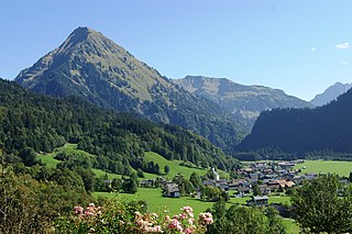
Au is a town in the Bregenz Forest in the westernmost Austrian state of Vorarlberg.

Mellau Place in Vorarlberg, Austria

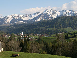
Mellau is a town in the Bregenz Forest in the westernmost Austrian state of Vorarlberg, part of the district of Bregenz.

Bezau Place in Vorarlberg, Austria

Bezau is a town in the Bregenz Forest region, in the western Austrian state of Vorarlberg. It is part of the district of Bregenz. Bezau is a popular tourist destination around the year, due to its vicinity to ski resorts and hiking trails. Its picturesque church was built in 1906 and has as its patron saint St. Jodok. Another attraction is the museum of local history (Heimatmuseum), which is housed in a traditional Bregenz Forest wooden home.

Bizau Place in Vorarlberg, Austria

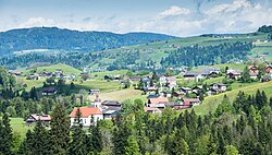
Bizau is a town in the Bregenz Forest in the Austrian state of Vorarlberg, part of the district Bregenz. The municipality has around 1080 inhabitants.

Egg, Austria Place in Vorarlberg, Austria

Egg is a market town in the Bregenz Forest, in the western Austrian state of Vorarlberg, part of the district of Bregenz. It is the has the highest population of any community in the Bregenzerwald.

Schwarzenberg, Austria Place in Vorarlberg, Austria

Schwarzenberg is a municipality in the Bregenz Forest in the western Austrian state of Vorarlberg, part of the district of Bregenz. Schwarzenberg has an area of 25.76 km². It lies south of Lake Constance. The village center is heritage-protected for its traditional rustic wooden houses.

Krumbach, Vorarlberg Place in Vorarlberg, Austria

Krumbach is a village in the westernmost Austrian state of Vorarlberg, in the Bregenz district. The municipality has about 1,000 inhabitants.

Schoppernau Place in Vorarlberg, Austria

Schoppernau is a town in the Bregenzerwald Region of the Austrian state of Vorarlberg. Schoppernau has an area of 47.64 km2.

Damüls Place in Vorarlberg, Austria

Damüls is a village community and popular tourist resort in the district of Bregenz in the westernmost Austrian state of Vorarlberg. Damüls also holds the European record as the village with the highest annual snowfall – the average is 9.30 meters per year. In 2006, Damüls was awarded the honorary title "the snowiest village in the world".

Andelsbuch Place in Vorarlberg, Austria

Andelsbuch is a municipality in the district of Bregenz in the Austrian state of Vorarlberg.

Doren Place in Vorarlberg, Austria

Doren is a municipality in the district of Bregenz in the western Austrian state of Vorarlberg.

Hittisau Place in Vorarlberg, Austria

Hittisau is a municipality in the district of Bregenz in the Austrian state of Vorarlberg. Hittisau has a surface area of 46.65 km². It lies in the Bregenzerwald in the west of the country.

Lingenau Place in Vorarlberg, Austria

Lingenau is a municipality in the district of Bregenz, in the westernmost Austrian state of Vorarlberg.

Sibratsgfäll Place in Vorarlberg, Austria

Sibratsgfäll is a municipality in the district of Bregenz in the Austrian state of Vorarlberg.

KäseStrasse Bregenzerwald

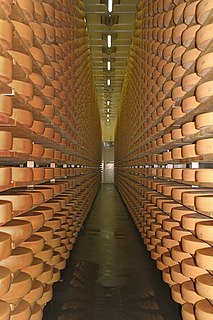
The KäseStrasse Bregenzerwald is a non-profit organisation and route which links cheese-producing businesses of the Bregenz Forest in Vorarlberg (Austria).

Vorarlberger Bergkäse

Vorarlberger Bergkäse is a regional cheese specialty from the Austrian state of Vorarlberg. It is protected within the framework of the European designation of origin (PDO).

References

  1. "Dauersiedlungsraum der Gemeinden Politischen Bezirke und Bundesländer - Gebietsstand 1.1.2018". Statistics Austria. Retrieved 10 March 2019.
  2. "Einwohnerzahl 1.1.2018 nach Gemeinden mit Status, Gebietsstand 1.1.2018". Statistics Austria. Retrieved 9 March 2019.