Reuthe

Last updated
Reuthe
Bregenzerwaldbahn.jpg
Wappen at reuthe.png
Reuthe im Bezirk B.png
Location in the district
Austria adm location map.svg
Red pog.svg
Reuthe
Location within Austria
Coordinates: 47°22′12″N09°53′36″E / 47.37000°N 9.89333°E / 47.37000; 9.89333
Country Austria
State Vorarlberg
District Bregenz
Government
   Mayor Bianca Moosbrugger Petter
Area
[1]
  Total10.24 km2 (3.95 sq mi)
Elevation
650 m (2,130 ft)
Population
 (2018-01-01) [2]
  Total658
  Density64/km2 (170/sq mi)
Time zone UTC+1 (CET)
  Summer (DST) UTC+2 (CEST)
Postal code
6870
Area code 05514
Vehicle registration B
Website www.reuthe.at

Reuthe is a municipality of the Bregenzerwald, in the westernmost Austrian state of Vorarlberg. It is located in the district of Bregenz. Its main industry is tourism.

Contents

Population

Historical population
YearPop.±%
1869315    
1880331+5.1%
1890257−22.4%
1900356+38.5%
1910357+0.3%
1923298−16.5%
1934349+17.1%
1939357+2.3%
1951418+17.1%
1961429+2.6%
1971534+24.5%
1981520−2.6%
1991578+11.2%
2001586+1.4%
2011611+4.3%

Geography

One of the smallest towns in Vorarlberg, with respect to population and geography, Reuthe has an area of 10.24 km2. 53.4% of the community area is forested, 11.6% is alpland.

Culture

The parish church Hl. Jakobus was built in 1248. In 2002 a new organ was installed.

Parish church St. Jakobus Pfarrkirche St Jakobus in Reuthe.jpg
Parish church St. Jakobus

Reuthe is part of the Bregenzerwald Umgang (literally "Bregenzerwald Walking Tour"). This walking tour offers insights into the architecture and community planning of 12 traditional villages in the Bregenzerwald. While walking over various landscapes, visiting public buildings, homes and everyday objects, walkers gain a comprehensive overview of typical Bregenzerwald architectural styles as they developed throughout the ages.

Related Research Articles

<span class="mw-page-title-main">Dornbirn</span> Place in Vorarlberg, Austria

Dornbirn is a city in the westernmost Austrian state of Vorarlberg. It is the administrative centre for the district of Dornbirn, which also includes the town of Hohenems, and the market town Lustenau.

<span class="mw-page-title-main">Lochau</span> Place in Vorarlberg, Austria

Lochau is a municipality in the westernmost Austrian state of Vorarlberg. It is located on Lake Constance, in the Bregenz district, near the border to Germany.

<span class="mw-page-title-main">Au, Vorarlberg</span> Place in Vorarlberg, Austria

Au is a town in the Bregenz Forest in Vorarlberg (Austria).

<span class="mw-page-title-main">Mellau</span> Place in Vorarlberg, Austria

Mellau is a town in the Bregenz Forest in the westernmost Austrian state of Vorarlberg, part of the district of Bregenz.

<span class="mw-page-title-main">Bezau</span> Place in Vorarlberg, Austria

Bezau is a town in the Bregenz Forest region, in the western Austrian state of Vorarlberg. It is part of the district of Bregenz. Bezau is a popular tourist destination around the year, due to its vicinity to ski resorts and hiking trails. Its picturesque church was built in 1906 and has as its patron saint St. Jodok. Another attraction is the museum of local history (Heimatmuseum), which is housed in a traditional Bregenz Forest wooden home.

<span class="mw-page-title-main">Bizau</span> Place in Vorarlberg, Austria

Bizau is a town in the Bregenz Forest in the Austrian state of Vorarlberg, part of the district Bregenz. The municipality has around 1080 inhabitants.

<span class="mw-page-title-main">Egg, Austria</span> Place in Vorarlberg, Austria

Egg is a market town in the Bregenz Forest, in the western Austrian state of Vorarlberg, part of the district of Bregenz. It is the has the highest population of any community in the Bregenzerwald.

<span class="mw-page-title-main">Schwarzenberg, Austria</span> Place in Vorarlberg, Austria

Schwarzenberg is a municipality in the Bregenz Forest in the western Austrian state of Vorarlberg, part of the district of Bregenz. Schwarzenberg has an area of 25.76 km². It lies south of Lake Constance. The village center is heritage-protected for its traditional rustic wooden houses.

<span class="mw-page-title-main">Krumbach, Vorarlberg</span> Place in Vorarlberg, Austria

Krumbach is a village in the westernmost Austrian state of Vorarlberg, in the Bregenz district. The municipality has about 1,000 inhabitants.

<span class="mw-page-title-main">Schoppernau</span> Place in Vorarlberg, Austria

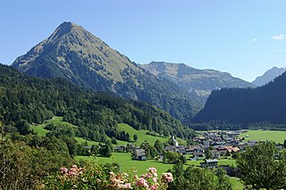
Schoppernau is a town in the Bregenzerwald Region of the Austrian state of Vorarlberg. Schoppernau has an area of 47.64 km2.

<span class="mw-page-title-main">Andelsbuch</span> Place in Vorarlberg, Austria

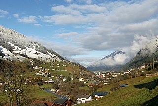
Andelsbuch is a municipality in the district of Bregenz in the Austrian state of Vorarlberg.

<span class="mw-page-title-main">Gemeinde Gaschurn-Partenen</span> Place in Vorarlberg, Austria

Gemeinde Gaschurn-Partenen is a municipality in the district of Bludenz in the westernmost Austrian state of Vorarlberg. The two largest villages are Gaschurn Dorf and Partenen.

<span class="mw-page-title-main">Doren</span> Place in Vorarlberg, Austria

Doren is a municipality in the district of Bregenz in the western Austrian state of Vorarlberg.

<span class="mw-page-title-main">Hittisau</span> Place in Vorarlberg, Austria

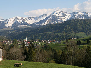
Hittisau is a municipality in the district of Bregenz in the Austrian state of Vorarlberg. Hittisau has a surface area of 46.65 km2. It lies in the Bregenzerwald in the west of the country.

<span class="mw-page-title-main">Langenegg</span> Place in Vorarlberg, Austria

Langenegg is a municipality with approx. 1,200 inhabitants in the westernmost Austrian state, Vorarlberg.

<span class="mw-page-title-main">Lingenau</span> Place in Vorarlberg, Austria

Lingenau is a municipality in the district of Bregenz, in the westernmost Austrian state of Vorarlberg.

<span class="mw-page-title-main">Riefensberg</span> Place in Vorarlberg, Austria

Riefensberg is a municipality in the district of Bregenz in the westernmost Austrian state of Vorarlberg. The community of Riefensberg covers an area of 14.85 square kilometers. Riefensberg is located within the Nagelfluhkette Nature Park.

<span class="mw-page-title-main">Schröcken</span> Place in Vorarlberg, Austria

Schröcken is a municipality in the district of Bregenz, in the westernmost Austrian state of Vorarlberg.

<span class="mw-page-title-main">Sibratsgfäll</span> Place in Vorarlberg, Austria

Sibratsgfäll is a municipality in the district of Bregenz in the Austrian state of Vorarlberg.

<span class="mw-page-title-main">Dünserberg</span> Place in Vorarlberg, Austria

Dünserberg is a municipality in the district of Feldkirch in the Austrian state of Vorarlberg.

References

  1. "Dauersiedlungsraum der Gemeinden Politischen Bezirke und Bundesländer - Gebietsstand 1.1.2018". Statistics Austria. Retrieved 10 March 2019.
  2. "Einwohnerzahl 1.1.2018 nach Gemeinden mit Status, Gebietsstand 1.1.2018". Statistics Austria. Retrieved 9 March 2019.