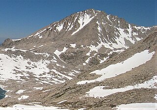
Mount Goode is a 13,085-foot-elevation mountain summit located on the crest of the Sierra Nevada mountain range in California, United States. It is situated on the shared boundary of Kings Canyon National Park with John Muir Wilderness, and along the common border of Fresno County with Inyo County. It is also approximately one mile west-northwest of Bishop Pass, one mile east-southeast of Mount Johnson, 1.23 miles (1.98 km) south of Hurd Peak, and 16 miles (26 km) west of the community of Big Pine.

Mount Thompson is a 13,494-foot-elevation mountain summit located on the crest of the Sierra Nevada mountain range in California, United States. It is situated on the shared boundary of Kings Canyon National Park with John Muir Wilderness, and along the common border of Fresno County with Inyo County. It is also 18 miles (29 km) west of the community of Big Pine, one mile northwest of Mount Gilbert, and three miles east of Mount Fiske, which is the nearest higher neighbor. Mount Thompson ranks as the 62nd-highest summit in California. This mountain's name commemorates Almon Harris Thompson (1839–1906). The first ascent of the peak was made by Clarence H. Rhudy and H. F. Katzenbach in the summer of 1909.

Black Giant is a 13,330-foot-elevation (4,060-meter) mountain summit located west of the crest of the Sierra Nevada mountain range, in Fresno County of central California, United States. Black Giant ranks as the 86th highest summit in California. It is the northernmost and highest summit on its namesake ridge, the Black Divide in northern Kings Canyon National Park. The peak is situated 3.9 miles (6.3 km) east of Mount Goddard, and 2.6 miles (4.2 km) south-southeast of Mount Fiske, which is the nearest higher neighbor. Topographic relief is significant as it rises 4,000 feet above Le Conte Canyon in approximately two miles. Muir Pass is 1.4 miles (2.3 km) to the northwest, and the approach to this remote peak is made via the John Muir Trail.

Langille Peak is a 12,018-foot-elevation (3,663-meter) mountain summit located west of the crest of the Sierra Nevada mountain range, in Fresno County of central California, United States. It is situated in northern Kings Canyon National Park, 19 miles (31 km) west-southwest of the community of Big Pine, 3 miles (4.8 km) south of Mount Thompson, 2.8 miles (4.5 km) southwest of Mount Goode, and 2.1 miles (3.4 km) east of Black Giant. Topographic relief is significant as the east aspect rises 3,100 feet above Le Conte Canyon in less than one mile. The approach to this remote peak is made via the John Muir Trail.

Mount Wynne is a 13,179-foot-elevation (4,017-meter) mountain summit located one mile west of the crest of the Sierra Nevada mountain range, in Fresno County of northern California, United States. It is situated in eastern Kings Canyon National Park, 31 miles (50 km) northwest of the town of Lone Pine, 0.4 miles immediately east of Pinchot Pass, and 0.66 miles (1.06 km) south of Mount Pinchot, which is the nearest higher neighbor. Mt. Wynne ranks as the 116th highest summit in California. Topographic relief is significant as the south aspect rises nearly 2,000 feet above the surrounding terrain in approximately one mile. The approach to this remote peak is made via the John Muir Trail. The first ascent of the summit was made in 1935 by a Sierra Club party.

Mount Warlow is a 13,206-foot-elevation mountain summit located 1.5 miles (2.4 km) west of the crest of the Sierra Nevada mountain range, in Fresno County of northern California, United States. It is situated on the Goddard Divide in northern Kings Canyon National Park, 1.2 miles (1.9 km) north of Muir Pass, 0.69 miles (1.11 km) southeast of Mount Huxley, and 0.68 miles (1.09 km) southwest of Mount Fiske, which is the nearest higher neighbor. Mount Warlow ranks as the 108th highest summit in California. The approach to this remote peak is made via the John Muir Trail.

Picture Puzzle, also known as Picture Puzzle Peak, is a 13,297-foot-elevation mountain summit located one mile east of the crest of the Sierra Nevada mountain range in Inyo County of northern California, United States. It is situated in the Palisades area of the John Muir Wilderness, on land managed by Inyo National Forest. It is approximately 14.5 miles (23.3 km) west of the community of Big Pine, one mile north of Bishop Pass, 0.8 miles (1.3 km) northwest of Aperture Peak, 1.2 miles (1.9 km) north-northwest of Mount Agassiz, and 1.1 miles (1.8 km) south-southwest of parent Cloudripper. Picture Puzzle ranks as the 90th-highest summit in California, and the third-highest peak of the Inconsolable Range.
East Vidette is a 12,356-foot-elevation (3,766-meter) mountain summit located two miles west of the crest of the Sierra Nevada mountain range, in the northeast corner of Tulare County in northern California. It is situated in Kings Canyon National Park, 12.5 miles (20.1 km) west-southwest of the community of Independence, and one mile southwest of the Kearsarge Pinnacles. Topographic relief is significant as the north aspect rises nearly 2,800 feet above Vidette Meadow in less than one mile. The John Muir Trail traverses below the north and east aspects of this remote peak. The first ascent of the summit was made in 1910 by a Sierra Club party via the East Ridge.

West Vidette is a 12,533-foot-elevation (3,820-meter) mountain summit located three miles west of the crest of the Sierra Nevada mountain range, in the northeast corner of Tulare County in northern California. It is situated in Kings Canyon National Park, 13.5 miles (21.7 km) west-southwest of the community of Independence, and 1.27 miles (2.04 km) west of East Vidette. Topographic relief is significant as the north aspect rises 4,300 feet above Junction Meadow in two miles. The John Muir Trail passes below the north aspect of this remote peak. The first ascent of the summit was made September 19, 1926, by Norman Clyde, who is credited with 130 first ascents, most of which were in the Sierra Nevada.

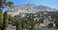
Mount Rixford is a 12,887-foot-elevation (3,928-meter) mountain summit located one mile west of the crest of the Sierra Nevada mountain range, in the southeast corner of Fresno County, in northern California. It is situated in Kings Canyon National Park, 11.5 miles (18.5 km) west of the community of Independence, and one mile north of the Kearsarge Pinnacles and Kearsarge Lakes. Topographic relief is significant as the north aspect rises 2,346 feet above Rae Lakes in one mile. The John Muir Trail crosses Glen Pass one mile to the west of this mountain. Mt. Rixford ranks as the 183rd highest summit in California. Painted Lady is a subsidiary summit at the end of Rixford's north ridge.

Crater Mountain is a 12,874-foot-elevation (3,924-meter) mountain summit located west of the crest of the Sierra Nevada mountain range, in Fresno County of northern California, United States. It is situated in eastern Kings Canyon National Park, 15.5 miles (24.9 km) northwest of the community of Independence, one mile immediately southwest of Pinchot Pass, and 1.3 miles (2.1 km) southeast of Mount Ickes, which is the nearest higher neighbor. Other nearby peaks include Mount Wynne, 1.5 miles (2.4 km) to the northeast, and Mount Cedric Wright, 2.2 miles (3.5 km) to the southeast. Crater Mountain ranks as the 186th highest summit in California. Topographic relief is significant as the west aspect rises 2,000 feet in less than one mile. The approach to this remote peak is made via the John Muir Trail which passes below the east aspect of the mountain. The first ascent of the summit was made July 19, 1922, by W. H. Ink, Meyers Butte, Frank Baxter, and Captain Wallace. This mountain has no crater as the name implies.

Mount Perkins is a 12,566-foot-elevation mountain summit located on the crest of the Sierra Nevada mountain range in northern California. It is situated on the common border of Fresno County with Inyo County, as well as the boundary between John Muir Wilderness and Kings Canyon National Park. It is 13.5 miles (21.7 km) northwest of the community of Independence, 1.65 miles (2.66 km) north of Mount Cedric Wright, 2.2 miles (3.5 km) east of Crater Mountain, and 1.4 miles (2.3 km) southeast of Mount Wynne. Climbing routes to the summit include the west slope, and the north and south ridges. The John Muir Trail traverses below the west base of the peak on its descent south from Pinchot Pass, providing an approach to the mountain.
Colosseum Mountain is a 12,473-foot-elevation double summit mountain located on the crest of the Sierra Nevada mountain range in northern California. It is situated on the common border of Fresno County with Inyo County, as well as the shared boundary of John Muir Wilderness and Kings Canyon National Park. It is 12 miles (19 km) northwest of the community of Independence, 1.2 miles (1.9 km) east of Mount Cedric Wright, 2.6 miles (4.2 km) west of Sawmill Point, and 1.6 miles (2.6 km) south-southeast of Mount Perkins, the nearest higher neighbor. The lower east summit is 12,451-feet in elevation and marked as Colosseum Mountain on maps, but the 12,473-foot west summit is higher. Approximately 1,000 feet distance separate the two summits. The John Muir Trail passes to the west of this peak, providing an approach to the mountain. The first ascent of the summit was made August 5, 1922, by Chester Versteeg, a prominent Sierra Club member, via the southwest face.

Fin Dome is an 11,673-foot-elevation (3,558-meter) granite summit located 1.5 mile west of the crest of the Sierra Nevada mountain range, in the southeast corner of Fresno County, in northern California. It is situated in the Rae Lakes area of Kings Canyon National Park, approximately 15.5 miles (24.9 km) west of the community of Independence. Nearby peaks include Black Mountain 1.9 miles (3.1 km) to the east, and Mount Rixford 2.1 miles (3.4 km) to the south-southeast. Topographic relief is significant as the east aspect rises 1,135 feet above Rae Lakes in one-quarter mile. The John Muir Trail passes to the east of this landmark, providing an approach. This geographical feature was named by Bolton Brown in 1899 when he explored the lake basin in its vicinity, because it resembled the fin of a sea serpent. The first ascent of the summit was made in 1910 by James Rennie, one of the foremost mountaineers of the Sierra Club.
Mount Hilgard is a 13,361-foot-elevation (4,072 meter) mountain summit located west of the crest of the Sierra Nevada mountain range in Fresno County of northern California, United States. It is situated in the John Muir Wilderness on land managed by Sierra National Forest, approximately eight miles east-southeast of Lake Thomas A Edison, and immediately above the west end of Lake Italy. The nearest higher neighbor is Mount Gabb, 1.75 miles (2.82 km) to the northeast, and Recess Peak is 2.2 miles (3.5 km) to the northwest. The John Muir Trail follows Bear Creek to the west of this remote peak, providing an approach. Mt. Hilgard ranks as the 82nd highest summit in California.

Mount Bago is an 11,870-foot-elevation (3,620-meter) mountain summit located west of the crest of the Sierra Nevada mountain range, in the southeast corner of Fresno County, in northern California. It is situated in Kings Canyon National Park, 14 miles (23 km) west of the community of Independence, 2.3 miles west of the Kearsarge Pinnacles, and 2.4 miles southwest of Mount Rixford. Topographic relief is significant as the south aspect rises 3,675 feet above Junction Meadow in one mile. The John Muir Trail passes to the northeast of this remote geographical feature. The first ascent of the summit was made July 11, 1896, by Joseph Nisbet LeConte and Wilson S. Gould.

Cardinal Mountain is a 13,396-foot-elevation mountain summit located on the crest of the Sierra Nevada mountain range in northern California. It is situated on the common border of Fresno County with Inyo County, as well as the shared boundary of John Muir Wilderness and Kings Canyon National Park. It is 14 miles (23 km) south-southwest of the community of Big Pine, approximately one mile north of Taboose Pass, and one mile south-southeast of Split Mountain, which is the nearest higher neighbor. Cardinal Mountain ranks as the 73rd highest summit in California. The first ascent of the summit was made August 11, 1922, by George Downing, Jr. The standard approach is via the Taboose Pass Trail, and the John Muir Trail passes west of this peak, providing an approach option to the mountain. The mountain's descriptive name was given by George R. Davis, a USGS topographer, on account of the brilliant red color of the roof pendant, like the red cap of a cardinal.
Goodale Mountain is a 12,772-foot-elevation (3,893-meter) mountain summit located one mile east of the crest of the Sierra Nevada mountain range, in Inyo County of northern California. It is situated less than two miles southeast of Taboose Pass in the John Muir Wilderness, on land managed by Inyo National Forest. It is also 16.5 miles (26.6 km) northwest of the community of Independence, and one mile northeast of Striped Mountain, the nearest higher neighbor. Topographic relief is significant as the east aspect rises 7,200 feet above Owens Valley in 3.5 miles. It ranks as the 218th highest peak in California.

Dragon Peak is a 12,955-foot-elevation (3,949 meter) mountain summit located on the crest of the Sierra Nevada mountain range in northern California. It is situated on the common border of Fresno County with Inyo County, as well as the boundary shared by John Muir Wilderness and Kings Canyon National Park. It is 10 miles (16 km) west of the community of Independence, and 1.3 miles (2.1 km) south of Black Mountain. Dragon Peak ranks as the 161st-highest summit in California. Topographic relief is significant as the north aspect rises 1,900 feet above Dragon Lake in less than one mile. This mountain is habitat for the endangered Sierra Nevada bighorn sheep, which restricts climbing from July through December, so most ascents are made in the spring. The first ascent of the summit was made in 1920 by either Norman Clyde, or Fred Parker and J. E. Rother. The John Muir Trail traverses two miles west of this peak, providing an approach option. The mountain is so named because of the shape of its outline as seen from Rae Lakes.

Painted Lady is a 12,126-foot-elevation (3,696-meter) mountain summit located in Fresno County, California.