
Waiheke Island is the second-largest island in the Hauraki Gulf of New Zealand. Its ferry terminal in Matiatia Bay at the western end is 21.5 km (13.4 mi) from the central-city terminal in Auckland.

Moturoa / Rabbit Island is a small island that lies across the southernmost part of Tasman Bay / Te Tai-o-Aorere, on the northern coast of New Zealand's South Island. The long narrow island runs east–west for 8 kilometres (5 mi), and covers 15 km2 (5.8 sq mi).

Colville, a small town in the north of the Coromandel Peninsula in the North Island of New Zealand, lies 26 kilometres north of Coromandel in Colville Bay on the Hauraki Gulf, and is the northernmost town of any note on the peninsula. North of Colville, 28 kilometres of rough road lead to the small settlement of Port Jackson, close to the peninsula's northwesternmost point, Cape Colville and 20 km to Port Charles on the northeastern side.

Stony Batter is a historic defence installation at the north-eastern end of Waiheke Island, Auckland, New Zealand. It is sited within a 50-acre scenic reserve of the same name, owned by the New Zealand Department of Conservation (DOC). The park serves double duty as a historical and nature reserve, containing unusual rock formations, associated with an extinct volcano, three significant bush blocks and three concrete gun emplacements with an extensive tunnel system, reputed to be the largest in New Zealand.
Mangateparu is a farming service community located close to the west bank of the Piako River, eight kilometres north of Morrinsville in the Waikato region of New Zealand. It has a population of about 400 people. The local school was forced to close in 2004.
Matiatia is a location at the western end of Waiheke Island, in New Zealand's Hauraki Gulf. The name is used for both a valley and its surrounding hills, with the valley stretching down to a foreshore and wharf on the gulf. Matiatia is known as "The Gateway to Waiheke Island".

Rotoroa Island is an island to the east of Waiheke Island in the Hauraki Gulf of New Zealand. It covers 82 hectares. The Salvation Army purchased it for £400 in 1908 from the Ruthe family to expand their alcohol and drug rehabilitation facility at nearby Pakatoa Island. Men were treated at Home Bay at Rotoroa, while women were treated at Pakatoa. This treatment facility was closed in 2005.
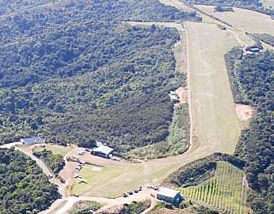
Waiheke Island Aerodrome is a private airport on Waiheke Island, 17 nautical miles northeast of Auckland, New Zealand.
Tāmaki Makaurau is a New Zealand parliamentary Māori electorate returning one Member of Parliament to the New Zealand House of Representatives. It was first formed for the 2002 election. The electorate covers central and southern Auckland, and southern parts of western Auckland. It derives its name from the Māori-language name for Auckland; Makaurau is a descriptive epithet referring to the value and desirability of the land.

Manaia is a locality on the western side of the Coromandel Peninsula of New Zealand. It lies to the east of State Highway 25, south of Coromandel and north of Tapu. The Manaia River flows from the Coromandel Range through the area and into the Manaia Harbour to the west. The harbour contains mussel farms.

Tarahiki Island, also known as Shag Island, is a 6 ha island in the Hauraki Gulf of New Zealand. Its highest point is 68 m (223 ft) ASL and it lies 15.6 km (9.7 mi) from the mainland and about 3 km (1.9 mi) east of Waiheke Island. It is well known for its breeding colony of up to 700 spotted shags.

The Waiheke River is a river of the West Coast Region of New Zealand's South Island. It flows west from its origins on Mount Barron in the Southern Alps to reach the Ahaura River, which it forms where it joins the Tūtaekurī River, 20 kilometres northwest of Lake Sumner.

Waikato District Council is the territorial authority for the Waikato District of New Zealand.

Horuhoru Rock (Gannet Rock) is an uninhabited rocky islet lying in the Hauraki Gulf, about 1.5 km north of the north-eastern end of Waiheke Island, New Zealand. It has been identified as an Important Bird Area by BirdLife International because it is a nesting site for about 2500 pairs of Australasian gannets.
Piarere is a locality in the Waikato region of New Zealand's North Island. It is situated on State Highway 29 close to its junction with State Highway 1, close to the shore of Lake Karapiro. The nearest towns are Tīrau, six kilometres to the southeast, Matamata, 10 kilometres to the northeast, and Cambridge, 10 kilometres to the northwest.

Waiheke United AFC is a football club based at Onetangi Sports Park on Waiheke Island, Auckland, New Zealand. The Senior Men's Team currently play in the NRFL Championship, having been relegated in 2022.
Ōtorohanga District Council is the territorial authority for the Ōtorohanga District of New Zealand.

Palm Beach is a settlement on Waiheke Island in northern New Zealand. The eponymous beach is named for phoenix palms at the eastern end, and has safe swimming and white sand.

Surfdale is a settlement on Waiheke Island in northern New Zealand. The original name being Okahu, Surfdale beach on Huruhi Bay has tidal mudflats, and is often used for windsurfing or kitesurfing. Shelly beach on Pukiki Bay is sandy and shelly. The area was developed in the mid–1920s.
Katherine Bay, alternatively spelt as Catherine Bay, is a bay located on the northwestern coast of Great Barrier Island, New Zealand. The bay was named in 1870 by Captain Nagle after his wife.


