
Leinster is one of the four provinces of Ireland, situated in the southeast and east of Ireland.

Dundalk is the county town of County Louth, Ireland. The town is on the Castletown River, which flows into Dundalk Bay on the east coast of Ireland. It is halfway between Dublin and Belfast, close to the border with Northern Ireland. It is surrounded by several townlands and villages that form the wider Dundalk Municipal District. It is the seventh largest urban area in Ireland, with a population of 43,112 as of the 2022 census.
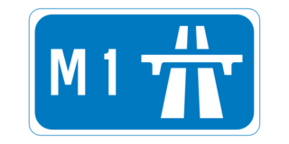
The M1 motorway is a motorway in Ireland. It forms the large majority of the N1 national primary road connecting Dublin towards Belfast along the east of the island of Ireland. The route heads north via Swords, Drogheda and Dundalk to the Northern Irish border just south of Newry in County Armagh, where it joins the A1 road and further on, the M1 motorway in Northern Ireland. It also forms a significant part of the road connection between Dublin and the Northern Irish cities of Newry, and Lisburn. The route is part of European route E01.

Sandymount is an affluent coastal suburb in the Dublin 4 district on the Southside of Dublin in Ireland.

Bundoran is a town in County Donegal, Ireland. The town is located near the N15 road near Ballyshannon, and is the most southerly town in Donegal. The town is a tourist seaside resort, and tourism has been at the heart of the local economy since the 18th century. Bundoran is a surfing destination and was listed by National Geographic magazine in 2012 as one of the world's top 20 surf towns.

Ardee is a town and townland in County Louth, Ireland. It is located at the intersection of the N2, N52, and N33 roads. The town shows evidence of development from the thirteenth century onward but as a result of the continued development of the town since then much of the fabric of the medieval town has been removed.

Kilkee is a small coastal town in County Clare, Ireland. It is in the parish of Kilkee, formerly Kilfearagh. Kilkee is midway between Kilrush and Doonbeg on the N67 road. The town is popular as a seaside resort. The horseshoe bay is protected from the Atlantic Ocean by the Duggerna Reef.
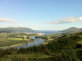
Carlingford Lough is a glacial fjord or sea inlet in northeastern Ireland, forming part of the border between Northern Ireland to the north and the Republic of Ireland to the south. On its northern shore is County Down, the Mourne Mountains, and the town of Warrenpoint; on its southern shore is County Louth, the Cooley Mountains and the village of Carlingford. The Newry River flows into the loch from the northwest.

Dunleer is a town and townland in County Louth, Ireland. Dunleer is situated midway between Dundalk and Drogheda and is located on the junction of the R132, R169 and R170 regional roads that intersect the town.

Carlingford is a coastal town and civil parish in northern County Louth, Ireland. For the purposes of local government, the town is part of the Dundalk Municipal District. It is situated on the southern shore of Carlingford Lough with Slieve Foy mountain as a backdrop, sometimes known as Carlingford Mountain. It is the main town on the Cooley Peninsula. Located on the R176/R173 roads between Greenore and Omeath village, Carlingford is approximately 27 km (17 mi) north east from Dundalk, 90 km (56 mi) north of Dublin and 11 km (7 mi) south of the border with Northern Ireland. Carlingford won the Irish Tidy Towns Competition in 1988.

Omeath is a village on the Cooley Peninsula in County Louth, Ireland, close to the border with Northern Ireland. It is roughly midway between Dublin and Belfast, very near the County Louth and County Armagh / County Down border. As of the 2016 census, Omeath had a population of 603, up from 439 during the 2006 census. It is approximately 6 km (3.7 mi) from Carlingford and about 8 km (5.0 mi) from Newry. By sea, Omeath's nearest land neighbour is Warrenpoint on the south County Down coast.
Culchie is a pejorative term in Hiberno-English for someone from rural Ireland. The term usually has a pejorative meaning directed by urban Irish against rural Irish, but since the late 20th century, the term has also been reclaimed by some who are proud of their rural or small town origin. In Dublin, the term culchie is often used to describe someone from outside County Dublin, including commuter towns such as Maynooth. In Belfast, Northern Ireland, the term is used to refer to persons from outside of the city proper but not necessarily outside the Greater Belfast area. The etymology of the term is unclear.

Laytown is a village in County Meath, Ireland, located on the R150 regional road and overlooking the Irish Sea. Historically it was called Ninch, after the townland it occupies. Together with the neighbouring villages of Mornington, Bettystown and Donacarney, it comprises the census town of Laytown–Bettystown–Mornington–Donacarney, which recorded a population of 15,642 in the 2022 census.

Castlebellingham is a village and townland in County Louth, Ireland. The village has become quieter since the construction of the new M1 motorway, which bypasses it. The population of Castlebellingham-Kilsaran increased from 721 inhabitants as of the 2002 census to 1,126 people as of the 2016 census.

Clogherhead is a fishing village in County Louth, Ireland. Located in a natural bay on the east coast it is bordered by the villages of Annagassan to the north and Termonfeckin to the south. It has a population of 2,145 according to the 2016 census. It is located in the townlands of Clogher and Callystown, about 12 km (7 mi) northeast of Drogheda. As a seaside village, its main industries are fishing and farming, and there has been an RNLI lifeboat stationed in the village for over 100 years.

Bettystown, previously known as Betaghstown and transliterated to Beattystown/Bettystown, is a village in County Meath, Ireland. Together with the neighbouring villages of Laytown, Mornington and Donacarney, it comprises the urban area of Laytown–Bettystown–Mornington–Donacarney with a combined population of 15,642 at the 2022 census. During the Celtic Tiger, with increasing property prices in Dublin, Bettystown expanded to cater for large numbers of commuters to Dublin. The area was well known before that as a spot for Dublin summer holiday visitors, with a number of caravan parks and seaside amusements.

Knockbridge is a village in County Louth, Ireland. It is located in the townland of Ballinlough in the historical barony of Dundalk Upper. As of the 2016 census, the village had a population of 667 people. Knockbridge won a "best kept village" award in the 2008 Tidy Towns competition.

Haggardstown is a townland and civil parish located in the barony of Upper Dundalk, on the southern outskirts of Dundalk, County Louth, Ireland. The civil parish of Haggardstown lies on the shore of Dundalk Bay, north of the estuary of the River Fane, and includes the village of Blackrock and Dundalk Golf Club.

Ravensdale is a village, townland and electoral division located at the foothills of the Cooley Mountains on the Cooley Peninsula in the north of County Louth in Ireland. Bordering with the townland of Doolargy, Ravensdale is approximately 8 km to the north of Dundalk. The dual carriageway between Dublin and Belfast runs nearby, and the R174 connects it with Jenkinstown.

Annagassan is a village in the townland of Ballynagassan, County Louth, Ireland. It sits where the River Glyde enters the Irish Sea. As of the 2022 census, Annagassan had a population of 189 people.


