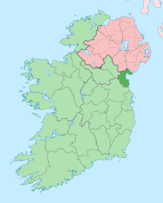
County Louth is a coastal county in the Eastern and Midland Region of Ireland, within the province of Leinster. Louth is bordered by the counties of Meath to the south, Monaghan to the west, Armagh to the north and Down to the north-east, across Carlingford Lough. It is the smallest county in Ireland by land area and the 17th most populous, with just over 139,100 residents as of 2022. The county is named after the village of Louth. Louth County Council is the local authority for the county.

Ardee is a town and townland in County Louth, Ireland. It is located at the intersection of the N2, N52, and N33 roads. The town shows evidence of development from the thirteenth century onward but as a result of the continued development of the town since then much of the fabric of the medieval town has been removed.

Dunleer is a town and townland in County Louth, Ireland. Dunleer is situated midway between Dundalk and Drogheda and is located on the junction of the R132, R169 and R170 regional roads that intersect the town. As of the 2022 census, the town had a population of 2,143.

Carrickmore is a small town in County Tyrone, Northern Ireland. It is situated in the historic barony of Omagh East, the civil parish of Termonmaguirk and the Roman Catholic Parish of Termonmaguirc between Cookstown, Dungannon and Omagh. It had a population of 612 in the 2001 Census. In the 2011 Census 2,330 people lived in the Termon Ward, which covers the Carrickmore and Creggan areas.

Keady is a village and civil parish in County Armagh, Northern Ireland. It is south of Armagh and near the border with the Republic of Ireland. It is situated mainly in the historic barony of Armagh with six townlands in the barony of Tiranny. It had a population of 3,051 people in the 2011 Census.

Scotshouse is a small agricultural village in the parish of Currin in County Monaghan, Ireland. It is roughly three miles east of where the counties of Cavan, Fermanagh and Monaghan meet. Scotshouse is about 7 kilometres (4 mi) from Clones, 18 km (11 mi) from Cavan town and 27 km (17 mi) away from Monaghan town.

Termonfeckin or Termonfechin is a small village and townland in County Louth, Ireland. It is within the parish of the same name, and lies repeatedly 8 km (5.0 mi) north-east of Drogheda. The population of the village almost quadrupled in the period between the 1996 and 2022 census, growing from 530 to 1,983 inhabitants.

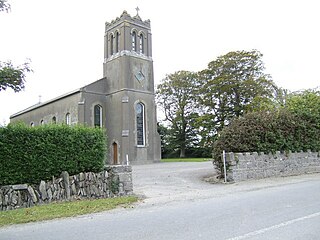
Dromiskin is a village and townland in County Louth, Ireland. It is situated 10 km south of Dundalk, about 1 km inland from the Irish coast.

Balscaddan is a village in Fingal, Ireland. It is the most northerly village of County Dublin, approx 5 km north of Balbriggan and close to the border with County Meath.
Ballymascanlan, otherwise Ballymascanlon, is a small village and townland in County Louth, Ireland, situated 4 km north-east of Dundalk on the Cooley Peninsula, on the road to Carlingford.

Tullyallen is a village, civil parish and townland 6 km north-west of the town of Drogheda in County Louth, Ireland. It is in the historic Barony of Ferrard. It is located in the historical Boyne Valley, in the Catholic parish of Mellifont ; it is also close to Newgrange, Knowth and Dowth burial mounds, Monasterboice monastery, and to the Battle of the Boyne site.

Clogherhead is a fishing village in County Louth, Ireland. Located in a natural bay on the east coast it is bordered by the villages of Annagassan to the north and Termonfeckin to the south. It has a population of 2,145 according to the 2016 census. It is located in the townlands of Clogher and Callystown, about 12 km (7 mi) northeast of Drogheda. As a seaside village, its main industries are fishing and farming, and there has been an RNLI lifeboat stationed in the village for over 100 years.

The Diocese of Armagh is the metropolitan diocese of the ecclesiastical province of Armagh, the Church of Ireland province that covers the northern half (approximately) of the island of Ireland. The diocese mainly covers counties Louth, Tyrone and Armagh, and parts of Down. The diocesan bishop is also the Archbishop of Armagh, the archbishop of the province, and the Primate of All Ireland. The Archbishop has his seat in St Patrick's Cathedral in the town of Armagh.
Togher is a large parish in County Louth, Ireland. A rural parish in the Roman Catholic Archdiocese of Armagh, Togher is situated approximately halfway between Drogheda and Dundalk.
Inniskeen, officially Inishkeen, is a small village, townland and parish in County Monaghan, Ireland, close to the County Louth and County Armagh borders. The village is located about 17 kilometres (11 mi) from Dundalk, 11 km (7 mi) from Carrickmacross, and 5 km (3 mi) from Crossmaglen. Seven townlands of this Roman Catholic Diocese of Clogher parish lie within County Louth.

Killeen or Killean is a small village and townland in the civil parish of Killeavy, County Armagh, Northern Ireland. It lies about four miles (6.5 km) south of Newry, near the border with County Louth in the Republic of Ireland.

Tinure is a small village and townland in the parish of Monasterboice, County Louth, Ireland. The official spelling of the village's name is Tinure however it is also sometimes referred to as "Tenure".

Ravensdale is a village, townland and electoral division located at the foothills of the Cooley Mountains on the Cooley Peninsula in the north of County Louth in Ireland. Bordering with the townland of Doolargy, Ravensdale is approximately 8 km to the north of Dundalk. The dual carriageway between Dublin and Belfast runs nearby, and the R174 connects it with Jenkinstown.

Ballindrait is a townland, village and census town in County Donegal, Ireland. Located near Lifford, the village and townland of Ballindrait is in the civil parish of Clonleigh and the barony of Raphoe North. The Burn Dale flows through the centre of Ballindrait.
Sandpit is a small village in the rural hinterland of Drogheda in County Louth, Ireland. It lies in the townland of Milltown, which had a population of 213 as of the 2011 census.


