Blowing Point, Anguilla

Last updated

Blowing Point
District
Anguilla Ferry Arrivals.jpg
Ferry Terminal
Anguilla location map.svg
Red pog.svg
Blowing Point
Coordinates: 18°10′38″N63°05′38″W / 18.1771°N 63.0939°W / 18.1771; -63.0939
CountryFlag of the United Kingdom.svg  United Kingdom
Overseas Territory Anguilla
Area
  Land5.15 km2 (1.99 sq mi)
Elevation
0 m (0 ft)
Population
 (2011) [1]
  Total870

Blowing Point is a village and one of the fourteen Districts of Anguilla, located on the southern coast. [2] It is home to Anguilla's ferry terminal.

Contents

Transport

Blowing Point Ferry Terminal Anguilla Ferry Terminal.jpg
Blowing Point Ferry Terminal

Ferry Terminal

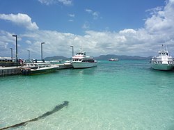
There are regular ferries from St. Martin to Anguilla providing a half hour service. [3] It is a 20-minute crossing from Marigot to Blowing Point. Ferries commence service from 7:00 AM. There are also a charter services, from Blowing Point to Princess Juliana Airport which connect to in- and outgoing international flights. [3] In 2007, 188,176 of the 271,959 people (both visitors and residents) entered Anguilla via the ferry terminal. [4] This way of travel is the most common method of transport between Anguilla and St. Martin or Sint Maarten. The exiting terminal will be redesigned and enlarged in 2021. [5]

Demographics

Historical population of Blowing Point, Anguilla
(Source: Statoids.com)
Year19741984199420012011
Population501463802779870 [1]

Notable people

Related Research Articles

<span class="mw-page-title-main">Anguilla</span> British Overseas Territory in the Leeward Islands

Anguilla is a British Overseas Territory in the Caribbean. It is one of the most northerly of the Leeward Islands in the Lesser Antilles, lying east of Puerto Rico and the Virgin Islands and directly north of Saint Martin. The territory consists of the main island of Anguilla, approximately 16 miles long by 3 miles (5 km) wide at its widest point, together with a number of much smaller islands and cays with no permanent population. The territory's capital is The Valley. The total land area of the territory is 35 square miles (91 km2), with a population of approximately 15,753 (2021).

<span class="mw-page-title-main">Transport in Anguilla</span>

One of the British overseas territories, the Caribbean island of Anguilla measures only 16 miles (26 km) long by 3 miles (4.8 km) wide, so transport is simpler than in many countries. There is no public transport, such as bus or rail systems, since there isn't enough need. However, Anguilla's roads are better maintained than on many Caribbean islands.

<span class="mw-page-title-main">King County, Washington</span> County in Washington, United States

King County is located in the U.S. state of Washington. The population was 2,269,675 in the 2020 census, making it the most populous county in Washington, and the 12th-most populous in the United States. The county seat is Seattle, also the state's most populous city.

<span class="mw-page-title-main">John Wayne Airport</span> International airport serving Orange County and Santa Ana, California, United States

John Wayne Airport is an international commercial and general aviation airport that serves Orange County, California, and the Greater Los Angeles area. The airport is located in an unincorporated area of Orange County, and it is owned and operated by the county. John Wayne Airport is surrounded by the cities of Irvine, Newport Beach, and Costa Mesa, although its IATA airport code and mailing address are both registered to Santa Ana, the county seat. Originally named Orange County Airport, the Orange County Board of Supervisors renamed the airport in 1979 in honor of actor John Wayne, who lived in neighboring Newport Beach and died that year. A statue of John Wayne was installed at the airline terminal in 1982.

<span class="mw-page-title-main">Staten Island Ferry</span> Passenger ferry service in New York City

The Staten Island Ferry is a fare-free passenger ferry route operated by the New York City Department of Transportation. The ferry's single route runs 5.2 miles (8.4 km) through New York Harbor between the New York City boroughs of Manhattan and Staten Island, with ferry boats making the trip in about 25 minutes. The ferry operates 24 hours a day, 7 days a week, with boats leaving every 15 to 20 minutes during peak hours and every 30 minutes at other times. Apart from NYC Ferry's St. George route, it is the only direct mass-transit connection between the two boroughs. Historically, the Staten Island Ferry has charged a relatively low fare compared to other modes of transit in the area; and since 1997, the route has been fare-free. The Staten Island Ferry is one of several ferry systems in the New York City area and is operated separately from systems like NYC Ferry and NY Waterway.

British Columbia Ferry Services Inc., operating as BC Ferries (BCF), is a former provincial Crown corporation, now operating as an independently managed, publicly owned Canadian company. BC Ferries provides all major passenger and vehicle ferry services for coastal and island communities in the Canadian province of British Columbia. Set up in 1960 to provide a similar service to that provided by the Black Ball Line and the Canadian Pacific Railway, which were affected by job action at the time, BC Ferries has become the largest passenger ferry line in North America, operating a fleet of 41 vessels with a total passenger and crew capacity of over 27,000, serving 47 locations on the B.C. coast.

<span class="mw-page-title-main">Hoboken Terminal</span> Commuter station in Hoboken, New Jersey

Hoboken Terminal is a commuter-oriented intermodal passenger station in Hoboken, Hudson County, New Jersey. One of the New York metropolitan area's major transportation hubs, it is served by eight NJ Transit (NJT) commuter rail lines, an NJ Transit event shuttle to Meadowlands Sports Complex, one Metro-North Railroad line, various NJT buses and private bus lines, the Hudson–Bergen Light Rail, the Port Authority Trans Hudson (PATH) rapid transit system, and NY Waterway-operated ferries.

<span class="mw-page-title-main">Transportation in St. Louis</span>

Transportation in Greater St. Louis, Missouri includes road, rail, ship, and air transportation modes connecting the bi-state St. Louis metropolitan area with surrounding communities throughout the Midwest, national transportation networks, and international locations. The Greater St. Louis region also supports a multi-modal transportation network that includes bus, paratransit, and light rail service in addition to shared-use paths, bike lanes and greenways.

<span class="mw-page-title-main">Rockaway Park, Queens</span> Neighborhood of Queens in New York City

Rockaway Park is a neighborhood in the New York City borough of Queens. The area is on the Rockaway Peninsula, nestled between Jamaica Bay to the north and the Atlantic Ocean to the south. The neighborhood of Rockaway Beach lies on its eastern border while the community of Belle Harbor is situated on its western side. The neighborhood is part of Queens Community Board 14.

<span class="mw-page-title-main">St. George Terminal</span> Transit center in Staten Island, New York

St. George Terminal is a ferry, railway, bus, and park and ride transit center in the St. George neighborhood of Staten Island, New York City. It is located at the intersection of Richmond Terrace and Bay Street, near Staten Island Borough Hall, SIUH Community Park and Richmond County Supreme Court. St. George is a rare example of a rail-boat connection in the United States.

<span class="mw-page-title-main">Marigot, Saint Martin</span> Largest city in the Collectivity of Saint Martin

Marigot is the main town and capital in the French Collectivity of Saint Martin.

<span class="mw-page-title-main">Battery Maritime Building</span> Ferry terminal in Manhattan, New York

The Battery Maritime Building is a building at South Ferry on the southern tip of Manhattan Island in New York City. Located at 10 South Street, near the intersection with Whitehall Street, it contains an operational ferry terminal at ground level, as well as a hotel and event space on the upper stories. The ground story contains three ferry slips that are used for excursion trips and ferries to Governors Island, as well as commuter trips to Port Liberté, Jersey City. The upper stories contain the Cipriani South Street event space, operated by Cipriani S.A., and a 47-room hotel called Casa Cipriani.

<span class="mw-page-title-main">Anguilla Channel</span>

The Anguilla Channel is a strait in the Caribbean Sea. It separates the island of Anguilla in the north from the Collectivity of Saint Martin, an overseas collectivity of France on the island of Saint Martin, in the south.

<span class="mw-page-title-main">Port Imperial</span> Intermodal transit hub in Weehawken, New Jersey, US

Port Imperial is a community centered around an intermodal transit hub on the Weehawken, New Jersey, waterfront of the Hudson River across from Midtown Manhattan, served by New York Waterway ferries and buses, Hudson–Bergen Light Rail, and NJT buses. The district lies under and at the foot of Pershing Road, a thoroughfare traveling along the face of the Hudson Palisades, which rise to its west. The Hudson River Waterfront Walkway runs along the shoreline and is abutted by recently constructed residential neighborhoods, Lincoln Harbor to the south and Bulls Ferry to the north.

<span class="mw-page-title-main">West Midtown Ferry Terminal</span> New York City passenger bus and ferry terminal

The West Midtown Ferry Terminal is a passenger bus and ferry terminal serving ferries along the Hudson River in New York City and northeastern New Jersey. It is located at Pier 79 in Hudson River Park adjacent to the West Side Highway at West 39th Street in Midtown Manhattan. The facility first opened in 1986 with the start of NY Waterway commuter ferry service.

<span class="mw-page-title-main">Battery Park City Ferry Terminal</span>

The Battery Park City Ferry Terminal, is a passenger ferry terminal in Battery Park City, Manhattan, serving ferries along the Hudson River in New York City and northeastern New Jersey. It provides slips to ferries, water taxis, and sightseeing boats in the Port of New York and New Jersey.

<span class="mw-page-title-main">East 34th Street Ferry Landing</span> Ferry terminal in Manhattan, New York

The East 34th Street Ferry Landing provides slips to ferries and excursion boats in the Port of New York and New Jersey. It is located on the East River in New York City east of the FDR Drive just north of East 34th Street in Midtown Manhattan. The facility, owned by the city, received Federal Highway Administration funding for improvements for docking facilities and upgrading the adjacent East River Greenway in 2008. A new terminal was built and completed in 2012.

<span class="mw-page-title-main">History of the Staten Island Railway</span>

The Staten Island Railway (SIR) is the only rapid transit line in the New York City borough of Staten Island and is operated by the Staten Island Rapid Transit Operating Authority, a unit of the Metropolitan Transportation Authority. The railway was historically considered a standard railroad line, but today only the western portion of the North Shore Branch, which is disconnected from the rest of the SIR, is used by freight and is connected to the national railway system.

<span class="mw-page-title-main">NYC Ferry</span> Ferry system in New York City

NYC Ferry is a public network of ferry routes in New York City operated by Hornblower Cruises. As of August 2023, there are six routes, as well as one seasonal route, connecting 25 ferry piers across all five boroughs. NYC Ferry has the largest passenger fleet in the United States with a total of 38 vessels, providing between 20 and 90 minute service on each of the routes, depending on the season.

Germain Hughes is an Anguillan professional footballer who plays as a defensive midfielder for TT Premier Football League club Cunupia F.C. and captains the Anguilla national team.

References

  1. 1 2 "Anguilla census data". Statoids.com. Archived from the original on 19 January 2018. Retrieved 11 May 2021.
  2. "General election set for February". Jamaica Gleaner . 7 January 2010. Archived from the original on 1 May 2024. Retrieved 23 January 2010.
  3. 1 2 Jacobs Consultancy 2008, p. 7.
  4. Jacobs Consultancy 2008, p. 17.
  5. "MINISTRY RELEASES BLOWING POINT FERRY TERMINAL DESIGN". The Anguillian. Archived from the original on 1 May 2024. Retrieved 11 May 2021.
  6. "Germain Hughes - Player Info". Global Sports Archive. Archived from the original on 12 May 2022. Retrieved 11 May 2021.

Bibliography

18°10′38″N63°05′38″W / 18.1771°N 63.0939°W / 18.1771; -63.0939