Bourn Brook, Cambridgeshire

Last updated
Bourn Brook
Bourn Brook from Barton Bridge - geograph.org.uk - 712420.jpg
Bourn Brook from Barton Bridge
Cambridgeshire UK relief location map.jpg
Red pog.svg
Location of the mouth within Cambridgeshire
Location
Country United Kingdom
County Cambridgeshire
Physical characteristics
Source 
  location Eltisley
  coordinates 52°13′03″N0°07′56″W / 52.2176°N 0.1321°W / 52.2176; -0.1321
  elevation62 m (203 ft)
Mouth  
  location
River Cam at Byron's Pool
  coordinates
52°10′17″N0°05′53″E / 52.1714°N 0.098°E / 52.1714; 0.098 Coordinates: 52°10′17″N0°05′53″E / 52.1714°N 0.098°E / 52.1714; 0.098
Length25.8 km (16.0 mi)
Basin size85 km2 (33 sq mi)

Bourn Brook is a minor tributary of the River Cam in Cambridgeshire, England.

Contents

Course

The Bourn Brook has its source just to the east of the village of Eltisley, 10 miles west of Cambridge, where the hills rise to around 60 metres above sea level. Minor tributaries known as the Eastern Brook, Hay Dean, Crow Dean and Gascote Dean merge just to the west of Caxton before it flows through Caxton, crossing the Roman road Ermine Street at its junction with the Bourn and Gransden roads. [1]

A footpath then follows its course to the outskirts of Bourn, where it is forded by the Caxton End road, and then bisects the village of Bourn. The village takes its name from the brook − "bourn" being another word for a brook. [2]

Flowing south-east from Bourn, it runs through Bourn Golf Course where it merges with the Dean Brook. Upon meeting the B1046 it turns east and runs alongside the former Varsity Line railway that closed in 1968. From this point until it reaches the River Cam it also forms the boundary between neighbouring parishes. Firstly it forms the northern parish boundary of Kingston then Great Eversden and the southern boundary of Caldecote and Toft, though at points it deviates slightly from the boundaries, indicating that its flow has altered since early medieval times. [3]

After skirting the southern edge of Toft village, it crosses the Prime Meridian still following the former railway line that is now used as part of the Mullard Radio Astronomy Observatory. Here it forms the southern boundary of Comberton and then Barton and the northern boundary of Little Eversden, Harlton, and Haslingfield parishes, though it flows some distance away from the villages themselves.

Finally it crosses the M11 motorway and forms the boundary between Grantchester and Haslingfield before flowing into the River Cam at Byron's Pool a few hundred metres south of Grantchester village, where the poet Lord Byron is reputed to have swum. [4]

Usage

Bourn Brook is used for angling, though there are few fish in its waters. The fish most commonly seen are small roach, dace and perch. [4]

Flooding

After exceptionally heavy rainfall, Bourn Brook has occasionally flooded, most notably in 2001 when it reached an all-time high of 3.11 meters at bourn causing significant damage was done to properties in Bourn and other villages. It regularly rises significantly in height making the Caxton End ford in Bourn impassable.

Information on the current height of the brook is available on the environment agency website for the Bourn and Comberton gauges, more information is available on twitter.

Related Research Articles

River Cam Tributary of the River Great Ouse

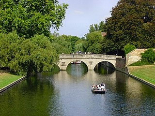
The River Cam is the main river flowing through Cambridge in eastern England. After leaving Cambridge, it flows north and east into the Great Ouse to the south of Ely at Pope's Corner. The Great Ouse connects the Cam to the North Sea at King's Lynn: The total distance from Cambridge to the sea is about 40 mi (64 km) and is navigable for punts, small boats, and rowing craft. The Great Ouse also connects to England's canal system via the Middle Level Navigations and the River Nene. In total, the Cam runs for around 69 kilometres (43 mi) from its furthest source to its confluence with the Great Ouse.

Grantchester Village and civil parish in Cambridgeshire, England

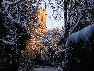
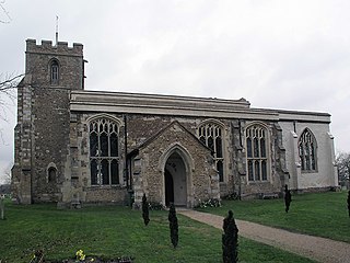
Grantchester is a village and civil parish on the River Cam or Granta in South Cambridgeshire, England. It lies about two miles (3 km) south of Cambridge.

South Cambridgeshire Non-metropolitan district in England

South Cambridgeshire is a mostly rural local government district of Cambridgeshire, England, with a population of 148,755 at the 2011 census. It was formed on 1 April 1974 by the merger of Chesterton Rural District and South Cambridgeshire Rural District. It completely surrounds the city of Cambridge, which is administered separately from the district by Cambridge City Council.

Caxton, Cambridgeshire Human settlement in England

Caxton is a small rural village and civil parish in the South Cambridgeshire district of Cambridgeshire, England. It is 9 miles west of the county town of Cambridge. In 2001, the population of Caxton parish was 480 people, increasing to 572 at the 2011 Census. Caxton is most famous for the Caxton Gibbet.

Comberton Village and civil parish in South Cambridgeshire, England

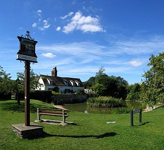
Comberton is a village and civil parish in South Cambridgeshire, England, just east of the Prime Meridian.

South Cambridgeshire (UK Parliament constituency)

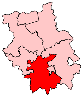
South Cambridgeshire is a constituency represented in the House of Commons of the UK Parliament since 2019 by Anthony Browne, a Conservative.

Chesterton is a former United Kingdom Parliamentary constituency. It was created upon the splitting up of the three member Cambridgeshire constituency into three single member divisions in 1885. The seat was abolished in 1918 when Cambridgeshire was recreated as a single-member constituency.

Little Eversden Human settlement in England

Little Eversden is a village approximately 7 miles (11 km) south-west of Cambridge, England. It has two main roads: Harlton Road which goes through Little Eversden and joins the A603, and High Street.

Trumpington Human settlement in England

Trumpington is a village and former civil parish on the outskirts of Cambridge, England, on the southwest side of the city bordering Cherry Hinton to the east, Grantchester to the west and Great Shelford and Little Shelford to the southeast. The village is an electoral ward of the City of Cambridge. The 2011 Census recorded the ward's population as 8,034.

Great Eversden Human settlement in England

Great Eversden is a village 6 miles south-west of Cambridge, England. The population of the civil parish at the 2011 Census was 241. The Prime Meridian runs through the parish just to the east of the village, separating it from Little Eversden.

River Bourne, Addlestone River in northwest Surrey, England

The River Bourne is the name given to a Thames tributary in northwest Surrey, England which has a longer tributary, the Windle Brook, that rises nears Bagshot Park in the south of Swinley Forest, Berkshire, merging with it while flowing through villages north of Woking; downstream the Bourne joins the Thames near Weybridge.

Great Comberton Human settlement in England

Great Comberton is a village in Worcestershire, England, United Kingdom.

Harlton Human settlement in England

Harlton is a village and civil parish in Cambridgeshire in the United Kingdom. The village is 5 miles (8.0 km) south-west of Cambridge and neighbours Haslingfield.

Bourn Human settlement in England

Bourn is a small village and civil parish in South Cambridgeshire, England. Surrounding villages include Caxton, Eltisley and Cambourne. It is 8 miles (12 km) from the county town of Cambridge. The population of the parish was 1,015 people at the time of the 2011 census.

River Granta Name referring to two of the four tributaries of the River Cam

The River Granta is the name of two of the four tributaries of the River Cam, although both names are often used synonymously. The Granta starts near the village of Widdington in Essex, flowing north past Audley End House to merge with the other contributary Rhee, which is also commonly called River Cam, a mile south of Grantchester. From source to its confluence with the Rhee it is 41.7 kilometres (25.9 mi) in length.

Caxton and Arrington Rural District

Caxton and Arrington was a rural district in Cambridgeshire, England, from 1894 to 1934.

References

  1. Ordnance Survey, Explorer Series. Sheet 208
  2. A History of the County of Cambridge and the Isle of Ely. 5. 1973. pp. 4–16.
  3. Ordnance Survey, Explorer Series. Sheet 209
  4. 1 2 Bourn Brook Archived March 26, 2012, at the Wayback Machine University Social Club