
Fairview Township is a township in Butler County, Pennsylvania, United States. The population was 1,942 at the 2020 census.

Hilbert is a village in Calumet County in the U.S. state of Wisconsin. The population was 1,248 at the 2020 census.

Mount Sterling is a village in Crawford County, Wisconsin, United States. The population was 189 at the 2020 census.

Tennyson is a village in Grant County, Wisconsin, United States, originally called Dutch Hollow. The population was 348 at the 2020 census.

Taylor is a village in Jackson County, Wisconsin, United States, along the Trempealeau River. The population was 484 at the 2020 census.

Fairbanks is a town in Shawano County, Wisconsin, United States. The population was 687 at the 2000 census. The unincorporated community of Split Rock is located in the town.

Pigeon Falls is a village in Trempealeau County, Wisconsin, United States. The population was 411 at the 2010 census.

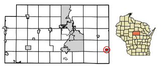
Big Falls is a village in Waupaca County, Wisconsin, United States. The population was 61 at the 2010 census.

Ogdensburg is a village in Waupaca County, Wisconsin, United States. The population was 185 at the 2010 census.

Birnamwood is a village in Marathon and Shawano counties in the U.S. state of Wisconsin. It is part of the Wausau, Wisconsin Metropolitan Statistical Area. The population was 818 at the 2010 census. Of this, 802 were in Shawano County, and 16 were in Marathon County. The village is located mostly within the town of Birnamwood in Shawano County; only a small portion extends into the town of Norrie in adjacent Marathon County.

Unity is a village in Clark and Marathon counties in the U.S. state of Wisconsin. It is part of the Wausau, Wisconsin Metropolitan Statistical Area. The population was 343 at the 2010 census. Of this, 204 were in Marathon County, and 139 were in Clark County. The village is located in northeastern town of Unity in Clark County and northwestern town of Brighton in Marathon County.

Randolph is a village in Columbia and Dodge counties in the U.S. state of Wisconsin. The population was 1,796 at the 2020 census. Of this, 1,338 were in Dodge County, and 458 were in Columbia County. The village is located at the southeast corner of the Town of Randolph in Columbia County, although only a tiny portion of the village lies within the town. Most of the village lies within the Town of Westford in Dodge County. Small portions also lie within the Town of Fox Lake to the north and the Town of Courtland in Columbia County.

Lowell is a village in Dodge County, Wisconsin, United States, along the Beaver Dam River. The population was 309 at the 2020 census. The village is located within the Town of Lowell.

Mount Hope is a village in Grant County, Wisconsin, United States. The population was 215 at the 2020 census. The village is located within the Town of Mount Hope.

Woodman is a village in Grant County in the U.S. state of Wisconsin. The population was 118 at the 2020 census. The village is located within the Town of Woodman.

Melrose is a village in Jackson County, Wisconsin, United States. The population was 503 at the 2010 census. The village is located within the Town of Melrose.

Necedah is a village in Juneau County, Wisconsin, United States. The population was 916 at the 2020 census. The village is located within the Town of Necedah.
Elderon is a village in Marathon County, Wisconsin, United States. It is part of the Wausau, Wisconsin Metropolitan Statistical Area. The population was 179 at the 2010 census.

Milltown is a village in Polk County, Wisconsin, United States. The population was 917 at the 2010 census. The village is located within the Town of Milltown.

Scandinavia is a village in the Town of Scandinavia in Waupaca County, Wisconsin, United States. The population was 328 at the 2010 census.


