Cecil, Wisconsin

Last updated

Cecil, Wisconsin
Cecil Wisconsin.jpg
Downtown Cecil
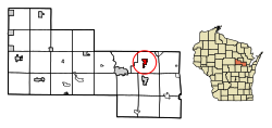
Shawano County Wisconsin Incorporated and Unincorporated areas Cecil Highlighted.svg
Location of Cecil in Shawano County, Wisconsin.
Coordinates: 44°48′34″N88°27′8″W / 44.80944°N 88.45222°W / 44.80944; -88.45222
Country Flag of the United States.svg  United States
State Flag of Wisconsin.svg  Wisconsin
County Shawano
Area
[1]
  Total1.80 sq mi (4.66 km2)
  Land1.79 sq mi (4.64 km2)
  Water0.01 sq mi (0.03 km2)
Elevation
[2]
807 ft (246 m)
Population
 (2010) [3]
  Total570
  Estimate 
(2019) [4]
551
  Density307.65/sq mi (118.78/km2)
Time zone UTC-6 (Central (CST))
  Summer (DST) UTC-5 (CDT)
Area code(s) 715 & 534
FIPS code 55-13325 [5]
GNIS feature ID1562830 [2]
Website villageofcecil.com

Cecil is a village in Shawano County, Wisconsin, United States. The population was 529 at the 2020 census. [6]

Contents

History

The village was named after a railroad man, Cecil Leavitt when the railroad was finished in 1884. [7]

Geography

Cecil is located at 44°48′34″N88°27′8″W / 44.80944°N 88.45222°W / 44.80944; -88.45222 (44.809442, -88.452323) [8] on the east shore of Shawano Lake.

According to the United States Census Bureau, the village has a total area of 1.80 square miles (4.66 km2), of which, 1.79 square miles (4.64 km2) of it is land and 0.01 square miles (0.03 km2) is water. [9]

Demographics

Historical population
CensusPop.Note
1910 351
1920 3798.0%
1930 356−6.1%
1940 3703.9%
1950 3956.8%
1960 357−9.6%
1970 3693.4%
1980 44520.6%
1990 373−16.2%
2000 46624.9%
2010 57022.3%
2019 (est.)551 [4] −3.3%
U.S. Decennial Census [10]

2010 census

As of the census [3] of 2010, there were 570 people, 262 households, and 162 families living in the village. The population density was 318.4 inhabitants per square mile (122.9/km2). There were 328 housing units at an average density of 183.2 per square mile (70.7/km2). The racial makeup of the village was 93.0% White, 0.2% African American, 4.2% Native American, 1.1% from other races, and 1.6% from two or more races. Hispanic or Latino of any race were 2.1% of the population.

There were 262 households, of which 24.0% had children under the age of 18 living with them, 51.5% were married couples living together, 6.9% had a female householder with no husband present, 3.4% had a male householder with no wife present, and 38.2% were non-families. 28.6% of all households were made up of individuals, and 11.5% had someone living alone who was 65 years of age or older. The average household size was 2.18 and the average family size was 2.63.

The median age in the village was 45.6 years. 17.7% of residents were under the age of 18; 6.9% were between the ages of 18 and 24; 24.1% were from 25 to 44; 31.7% were from 45 to 64; and 19.5% were 65 years of age or older. The gender makeup of the village was 47.5% male and 52.5% female.

2000 census

As of the census [5] of 2000, there were 466 people, 199 households, and 148 families living in the village. The population density was 339.0 people per square mile (131.3/km2). There were 246 housing units at an average density of 179.0 per square mile (69.3/km2). The racial makeup of the village was 94.85% White, 3.43% Native American, 0.64% Asian, 0.64% from other races, and 0.43% from two or more races. Hispanic or Latino of any race were 0.64% of the population.

There were 199 households, out of which 24.6% had children under the age of 18 living with them, 62.8% were married couples living together, 8.5% had a female householder with no husband present, and 25.6% were non-families. 22.6% of all households were made up of individuals, and 6.5% had someone living alone who was 65 years of age or older. The average household size was 2.34 and the average family size was 2.70.

In the village, the population was spread out, with 19.7% under the age of 18, 9.4% from 18 to 24, 24.5% from 25 to 44, 24.2% from 45 to 64, and 22.1% who were 65 years of age or older. The median age was 43 years. For every 100 females, there were 96.6 males. For every 100 females age 18 and over, there were 98.9 males.

The median income for a household in the village was $38,958, and the median income for a family was $39,792. Males had a median income of $37,188 versus $23,750 for females. The per capita income for the village was $18,918. About 3.8% of families and 5.7% of the population were below the poverty line, including 10.6% of those under age 18 and 3.5% of those age 65 or over.

Images

Related Research Articles

<span class="mw-page-title-main">Mechanicsburg, Illinois</span> Village in Illinois, United States

Mechanicsburg is a village in Sangamon County, Illinois, United States. The population was 590 at the 2010 census. It is part of the Springfield, Illinois Metropolitan Statistical Area.

<span class="mw-page-title-main">Hudson, Iowa</span> City in Iowa, United States

Hudson is a city in Black Hawk County, Iowa, United States. The population was 2,546 at the time of the 2020 census. The rural community of Hudson has grown in recent years and is included as a part of the Waterloo-Cedar Falls Metropolitan Statistical Area.

<span class="mw-page-title-main">Cecil, Ohio</span> Village in Ohio, United States

Cecil is a village in Paulding County, Ohio, United States. The population was 146 at the 2020 census.

<span class="mw-page-title-main">Normandy, Tennessee</span> Town in Tennessee, United States

Normandy is a town in Bedford County, Tennessee. The population was 108 at the 2020 census. Normandy Dam is located just northeast of the town. The town is listed on the National Register of Historic Places as the Normandy Historic District. The historic Beech Hall is also located near Normandy.

<span class="mw-page-title-main">Bellevue, Wisconsin</span> Village in Wisconsin, United States

Bellevue is a village in Brown County, Wisconsin. It was a town until incorporating as a village on February 14, 2003. The population was 15,935 at the time of the 2020 census. Bellevue is part of the Green Bay metropolitan area. Bellevue sits around 4.34 miles (6.99 km) east from central Green Bay.

<span class="mw-page-title-main">Avoca, Wisconsin</span> Village in Wisconsin, United States

Avoca is a village in Iowa County, Wisconsin, United States. The population was 637 at the 2010 census. It is part of the Madison Metropolitan Statistical Area. It is named after Avoca in Ireland.

<span class="mw-page-title-main">Bay City, Wisconsin</span> Village in Wisconsin, United States

Bay City is a village on the Mississippi River in Pierce County, Wisconsin, United States. The population was 500 at the 2010 census.

Gilman is a town in Pierce County, Wisconsin, United States. The population was 772 as of the 2000 census. The unincorporated communities of Olivet and Viking are partially located in the town.

<span class="mw-page-title-main">Grant, Shawano County, Wisconsin</span> Town in Wisconsin, United States

Grant is a town in Shawano County, Wisconsin, United States. The population was 974 at the 2000 census. The unincorporated community of Caroline is located within the town, and it holds the town's fire station.

<span class="mw-page-title-main">Gresham, Wisconsin</span> Village in Wisconsin, United States

Gresham is a village in Shawano County, Wisconsin, United States. The population was 586 at the 2010 census.

<span class="mw-page-title-main">Mattoon, Wisconsin</span> Village in Wisconsin, United States

Mattoon is a village in Shawano County, Wisconsin, United States. The population was 438 at the 2010 census.

<span class="mw-page-title-main">Navarino, Wisconsin</span> Town in Wisconsin, United States

Navarino is a town in Shawano County, Wisconsin, United States. As of the 2010 census, its population is 177. For statistical purposes, the United States Census Bureau has defined Navarino as a census-designated place (CDP). The census-designated place and community of Navarino is located in the town.

<span class="mw-page-title-main">Red Springs, Wisconsin</span> Town in Wisconsin, United States

Red Springs is a town in Shawano County, Wisconsin, United States. As of the 2010 census, the town had a total population of 925. The unincorporated community of Morgan is located in the town. The census-designated place of Middle Village is also located partially in the town.

<span class="mw-page-title-main">Wilson, St. Croix County, Wisconsin</span> Village in Wisconsin, United States

Wilson is a village in St. Croix County, Wisconsin, United States. The population was 184 at the 2010 census.

<span class="mw-page-title-main">Ogdensburg, Wisconsin</span> Village in Wisconsin, United States

Ogdensburg is a village in Waupaca County, Wisconsin, United States. The population was 185 at the 2010 census.

<span class="mw-page-title-main">Wilson, Ohio</span> Village in Ohio, United States

Wilson is a village in Belmont and Monroe counties in the U.S. state of Ohio. The population was 129 at the 2020 census. It is part of the Wheeling metropolitan area.

<span class="mw-page-title-main">Verona, Ohio</span> Village in Ohio, United States

Verona is a village in Montgomery and Preble counties in the U.S. state of Ohio. The population was 403 at the 2020 census. It is part of the Dayton Metropolitan Statistical Area.

<span class="mw-page-title-main">Birnamwood, Wisconsin</span> Village in Wisconsin, United States

Birnamwood is a village in Marathon and Shawano counties in the U.S. state of Wisconsin. It is part of the Wausau, Wisconsin Metropolitan Statistical Area. The population was 818 at the 2010 census. Of this, 802 were in Shawano County, and 16 were in Marathon County. The village is located mostly within the town of Birnamwood in Shawano County; only a small portion extends into the town of Norrie in adjacent Marathon County.

<span class="mw-page-title-main">Rosendale, Wisconsin</span> Village in Wisconsin, United States

Rosendale is a village in Fond du Lac County, Wisconsin, United States. The population was 1,063 at the 2010 census. The village is located partially within the Town of Rosendale and partially within the Town of Springvale.

<span class="mw-page-title-main">Aniwa (town), Wisconsin</span>

Aniwa is a town in Shawano County, Wisconsin, United States. The population was 586 at the 2000 census. The Village of Aniwa is located within the town.

References

  1. "2019 U.S. Gazetteer Files". United States Census Bureau. Retrieved August 7, 2020.
  2. 1 2 "US Board on Geographic Names". United States Geological Survey. October 25, 2007. Retrieved January 31, 2008.
  3. 1 2 "U.S. Census website". United States Census Bureau . Retrieved November 18, 2012.
  4. 1 2 "Population and Housing Unit Estimates". United States Census Bureau. May 24, 2020. Retrieved May 27, 2020.
  5. 1 2 "U.S. Census website". United States Census Bureau . Retrieved January 31, 2008.
  6. "Explore Census Data". data.census.gov. Retrieved April 30, 2024.
  7. Village of Cecil, Wisconsin-History
  8. "US Gazetteer files: 2010, 2000, and 1990". United States Census Bureau. February 12, 2011. Retrieved April 23, 2011.
  9. "US Gazetteer files 2010". United States Census Bureau. Archived from the original on January 25, 2012. Retrieved November 18, 2012.
  10. "Census of Population and Housing". Census.gov. Retrieved June 4, 2015.